 Old Cumbria Gazetteer
 |
 |
|
| Rawlinson Nab, Satterthwaite | ||
| Rawlinson Nab | ||
| site name:- | Windermere lake | |
| civil parish:- | Satterthwaite (formerly Lancashire) | |
| county:- | Cumbria | |
| locality type:- | headland | |
| coordinates:- | SD38599306 | |
| 1Km square:- | SD3893 | |
| 10Km square:- | SD39 | |
|
|
||
| evidence:- | old map:- OS County Series (Lan 5 15) placename:- Rawlinson Nab |
|
| source data:- | Maps, County Series maps of Great Britain, scales 6 and 25
inches to 1 mile, published by the Ordnance Survey, Southampton,
Hampshire, from about 1863 to 1948. OS County Series (Wmd 37 7) |
|
|
|
||
| evidence:- | old map:- Jefferys 1770 (Wmd) |
|
| source data:- | Map, 4 sheets, The County of Westmoreland, scale 1 inch to 1
mile, surveyed 1768, and engraved and published by Thomas
Jefferys, London, 1770.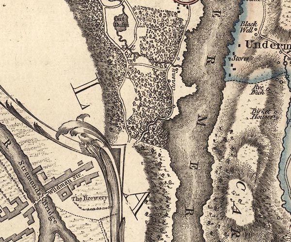 J5SD39SE.jpg headland item:- National Library of Scotland : EME.s.47 Image © National Library of Scotland |
|
|
|
||
| evidence:- | descriptive text:- West 1778 (11th edn 1821) placename:- Rawlinson's Nab |
|
| source data:- | Guide book, A Guide to the Lakes, by Thomas West, published by
William Pennington, Kendal, Cumbria once Westmorland, and in
London, 1778 to 1821. goto source goto sourcePage 65:- "... Rawlinson's-nab is a peninsular-rock, of a circular figure, swelling to a crown in the centre, covered with a low wood;" |
|
|
|
||
| evidence:- | old map:- Crosthwaite 1783-94 (Win/Ble) placename:- Rawlinson's Nab |
|
| source data:- | Map, uncoloured engraving, An Accurate Map of the Grand Lake of
Windermere, scale about 2 inches to 1 mile, by Peter
Crosthwaite, Keswick, Cumberland, 1783, version published 1819.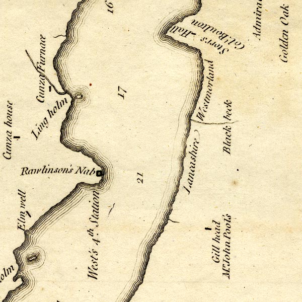 CT9SD39W.jpg "Rawlinson's Nab" headland item:- Armitt Library : 2008.14.102 Image © see bottom of page |
|
|
|
||
| evidence:- | old map:- West 1784 map placename:- Rawlinson's Nab |
|
| source data:- | Map, hand coloured engraving, A Map of the Lakes in Cumberland,
Westmorland and Lancashire, scale about 3.5 miles to 1 inch,
engraved by Paas, 53 Holborn, London, about 1784.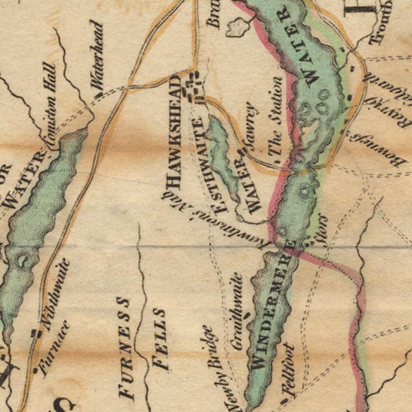 Ws02SD39.jpg item:- Armitt Library : A1221.1 Image © see bottom of page |
|
|
|
||
| evidence:- | old map:- Clarke 1787 map (Windermere S) placename:- Rawlinson Nab |
|
| source data:- | Map, A Map of the Southern Part of the Lake Winandermere and its
Environs, scale about 6.5 ins to 1 mile, by James Clarke,
engraved by Samuel John Neele, 352 Strand, published by James
Clarke, Penrith, Cumberland and in London etc, 1787.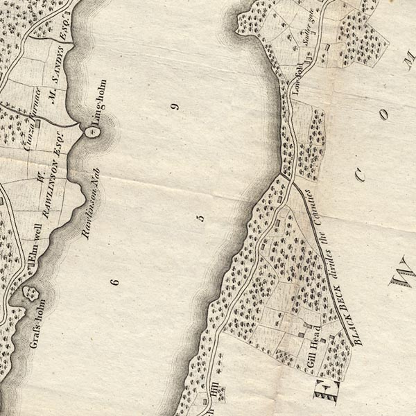 CLBSD39W.jpg "Rawlinson Nab" item:- private collection : 10.11 Image © see bottom of page |
|
|
|
||
| evidence:- | old map:- Prior 1874 map 1 placename:- Rawlinson's Nab |
|
| source data:- | Map, uncoloured engraving or lithograph? Winander Mere, scale
about 2.5 miles to 1 inch, published by John Garnett,
Windermere, Westmorland, 1874. click to enlarge click to enlargePI03M1.jpg "Rawlinson's Nab" headland item:- private collection : 133.1 Image © see bottom of page |
|
|
|
||
| evidence:- | old print:- Tattersall 1836 (version 1869) placename:- Rawlinson's Nab |
|
| source data:- | Print, hand coloured, Lower Reach, Windermere, Westmorland, drawn by George Tattersall,
1836, engraved by W F Topham, published by T J Allman, 463 Oxford Street, London,
1869.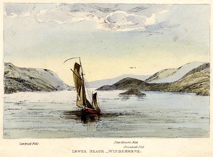 click to enlarge click to enlargeTAT201.jpg Frontispiece to The Lakes of England, by W F Topham. printed at bottom:- "LOWER REACH - WINDERMERE." printed at bottom:- "Cartmel Fells. / Rawlinson's Nab. / Grisedale Fell." item:- Armitt Library : A1067.1 Image © see bottom of page |
|
|
|
||
| evidence:- | outline view:- Tattersall 1836 placename:- Rawlinson's Nab item:- boat; sailing boat |
|
| source data:- | Print, engraving, Lower Reach, Windermere, Westmorland, drawn by George Tattersall,
engraved by W F Topham, published by Sherwood and Co, Paternoster Row, London, about
1836.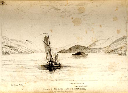 click to enlarge click to enlargeTAT103.jpg The print is captioned with mountain names and acts as an outline view. Tipped in opposite p.30 of The Lakes of England, by George Tattersall. printed at bottom:- "LOWER REACH, WINDERMERE. / Pubd April 15th. 1836, by Sherwood &Co. / [London]" printed at bottom left to right:- "Cartmel Fells. / Rawlinson's Nab. / Grisedale Fell." item:- Armitt Library : A1204.4 Image © see bottom of page |
|
|
|
||
Lakes Guides menu.