 Old Cumbria Gazetteer
 |
 |
|
| Tongue Gill Mine, Lakes | ||
| Tongue Gill Mine | ||
| Providence Mine | ||
| locality:- | Tongue Gill | |
| civil parish:- | Lakes (formerly Westmorland) | |
| county:- | Cumbria | |
| locality type:- | iron mine | |
| locality type:- | mine | |
| coordinates:- | NY339105 | |
| 1Km square:- | NY3310 | |
| 10Km square:- | NY31 | |
| references:- | Adams, John: 1988: Mines of the Lake District Fells: Dalesman Books (Lancaster, Lancashire)::
ISBN 0 85206 931 6 |
|
|
|
||
| evidence:- | old map:- Postlethwaite 1877 (3rd edn 1913) placename:- Tongue Gill Iron Mine |
|
| source data:- | Map, uncoloured engraving, Map of the Lake District Mining Field, Westmorland, Cumberland,
Lancashire, scale about 5 miles to 1 inch, by John Postlethwaite, published by W H
Moss and Sons, 13 Lowther Street, Whitehaven, Cumberland, 1877 edn 1913.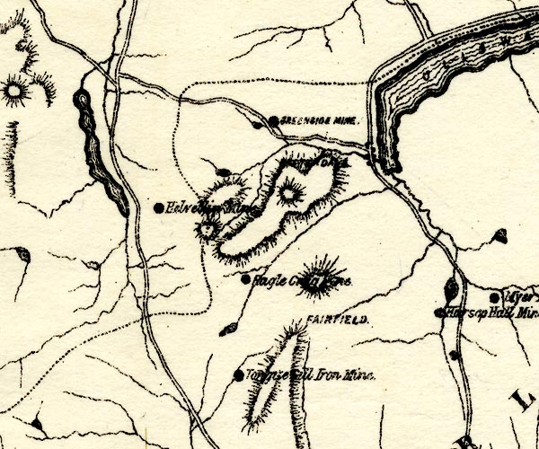 PST2NY31.jpg "Tongue Gill Iron Mine" mine symbol item:- JandMN : 162.2 Image © see bottom of page |
|
|
|
||
| :- |
North of Little Tongue Gill. Haematite veins worked about 1700; last worked 1876. |
|
| Adams, John: 1988: Mines of the Lake District Fells: Dalesman Books (Lancaster, Lancashire)::
ISBN 0 85206 931 6 |
||
|
|
||
 Lakes Guides menu.