 Old Cumbria Gazetteer
 |
 |
|
| Priest Pot, Claife | ||
| runs into:- |  Esthwaite Water Esthwaite Water |
|
|
|
||
| Priest Pot | ||
| locality:- | Hawkshead | |
| civil parish:- | Claife (formerly Lancashire) | |
| county:- | Cumbria | |
| locality type:- | tarn | |
| locality type:- | fish pond | |
| coordinates:- | SD35759784 | |
| 1Km square:- | SD3597 | |
| 10Km square:- | SD39 | |
| altitude:- | 216 feet | |
| altitude:- | 66m | |
|
|
||
| evidence:- | old map:- OS County Series (Lan 5 2) placename:- Priest Pot |
|
| source data:- | Maps, County Series maps of Great Britain, scales 6 and 25
inches to 1 mile, published by the Ordnance Survey, Southampton,
Hampshire, from about 1863 to 1948. |
|
|
|
||
| evidence:- | descriptive text:- Otley 1823 (5th edn 1834) item:- floating island |
|
| source data:- | Guide book, A Concise Description of the English Lakes, the
mountains in their vicinity, and the roads by which they may be
visited, with remarks on the mineralogy and geology of the
district, by Jonathan Otley, published by the author, Keswick,
Cumberland now Cumbria, by J Richardson, London, and by Arthur
Foster, Kirkby Lonsdale, Cumbria, 1823; published 1823-49,
latterly as the Descriptive Guide to the English Lakes. goto source Page 13:- "..." "On a pond called Priest Pot, near the head of this lake [Esthwaite Water], there is a Floating Island 24 yards in length, and 5 or 6 in breadth; ..." |
|
|
|
||
| evidence:- | old text:- Martineau 1855 placename:- Priest's Pot |
|
| source data:- | Guide book, A Complete Guide to the English Lakes, by Harriet
Martineau, published by John Garnett, Windermere, Westmorland,
and by Whittaker and Co, London, 1855; published 1855-76. goto source Page 29:- "... A round pond at the northern end of the lake [Esthwaite Water], connected with it by a narrow creek, ... The name of the pond is Priest's Pot: a fact which be explain by a tradition that a priest was drowned there; and others by a supposition of its" goto sourcePage 30:- "holding about as much as a thirsty priest would like to drink, if the liquor were sufficiently good. ..." |
|
|
|
||
| evidence:- | old photograph:- Bell 1880s-1940s |
|
| source data:- | Photograph, black and white, Priest Pot, Claife, and Hawkshead, Lancashire, by Herbert
Bell, photographer, Ambleside, Westmorland, 1890s.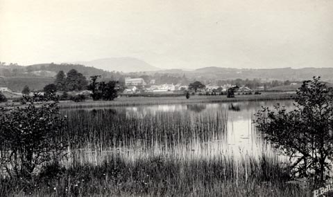 click to enlarge click to enlargeHB0581.jpg internegative at lower right:- "H. Bell" stamped on reverse:- "HERBERT BELL / Photograph / AMBLESIDE" item:- Armitt Library : ALPS241 Image © see bottom of page |
|
|
|
||
| evidence:- | old print:- Robertson 1911 placename:- Priest's Pot Pool |
|
| source data:- | Print, lithograph? Hawkshead, from a watercolour by Arthur Tucker, published by Chatto
and Windus, London, 1911.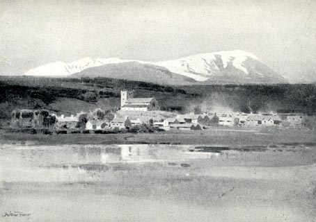 click to enlarge click to enlargeRSN116.jpg Tipped in opposite p.64 of Wordsworthshire by Eric Robertson. printed at bottom:- "HAWKSHEAD / ('Priest's Pot' Pool in foreground; Weatherlam covered with snow)" signed at painting lower left:- "Arthur Tucker" item:- JandMN : 197.16 Image © see bottom of page |
|
|
|
||
| hearsay:- |
Used as a fish pond by the monks of Furness Abbey. |
|
|
|
||
Lakes Guides menu.