 Old Cumbria Gazetteer
 |
 |
|
| Pike of Stickle, Lakes | ||
| Pike of Stickle | ||
| Pike o' Stickle | ||
| Sugar Loaf | ||
| site name:- | Langdale Pikes | |
| civil parish:- | Lakes (formerly Westmorland) | |
| county:- | Cumbria | |
| locality type:- | hill | |
| locality type:- | rocks | |
| coordinates:- | NY27390736 | |
| 1Km square:- | NY2707 | |
| 10Km square:- | NY20 | |
| altitude:- | 2326 feet | |
| altitude:- | 709m | |
|
|
||
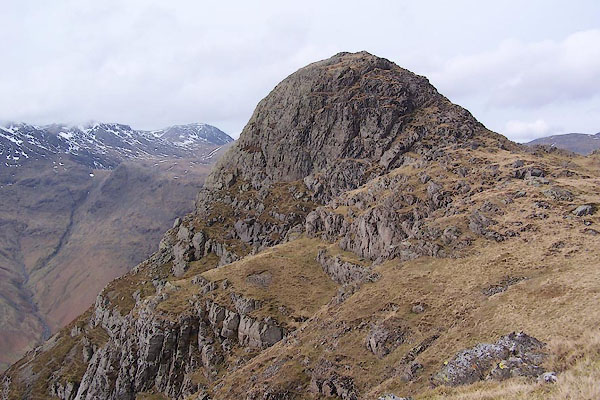 BSI91.jpg (taken 23.3.2010) 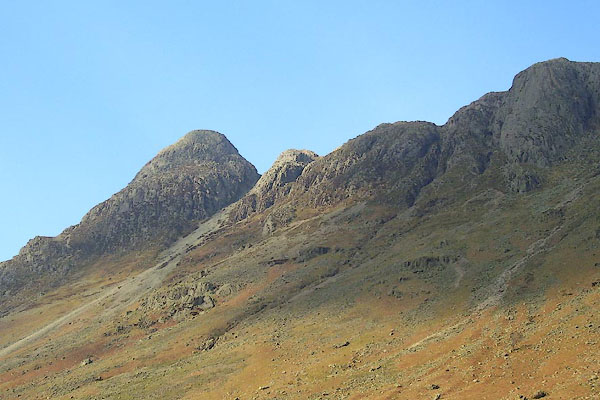 BNL51.jpg (taken 26.3.2007) |
||
|
|
||
| evidence:- | old map:- OS County Series (Wmd 25 2) placename:- Pike of Stickle |
|
| source data:- | Maps, County Series maps of Great Britain, scales 6 and 25
inches to 1 mile, published by the Ordnance Survey, Southampton,
Hampshire, from about 1863 to 1948. |
|
|
|
||
| evidence:- | old text:- Green 1810 placename:- Stickle Pike |
|
| source data:- | Set of prints, soft ground etchings, Sixty Studies from Nature,
by William Green, Ambleside, Westmorland, drawn 1808-10,
published 1810. goto source goto sourcepage 104:- "..." "Should the traveller wish to ascend to the top of that Pike of Langdale which is called Stickle Pike, ... he must commence his labours at Mill Beck. The Ambleside guide, or a person from Mill Beck, will, perhaps, take him by Dungeon Gill, and from the top of the Dungeon, to the top of the Pike or to the Tarn; but some parts of the road are so steep as to be painfully unpleasant to such as have not been much accustomed to scrambling. ..." page 105:- "... Leaving the foot of the Tarn on the edge of the hill, a peat or turf road soon appears, on which descend to Mill Beck; the eye of the spectator, whether directed up or down the valley, is cheared all the way with views of fields, richly bedecked with wood, and encircled by high mountains. ..." |
|
|
|
||
| evidence:- | old map:- Otley 1818 placename:- Stickle Pikes |
|
| source data:- | Map, uncoloured engraving, The District of the Lakes,
Cumberland, Westmorland, and Lancashire, scale about 4 miles to
1 inch, by Jonathan Otley, 1818, engraved by J and G Menzies,
Edinburgh, Scotland, published by Jonathan Otley, Keswick,
Cumberland, et al, 1833.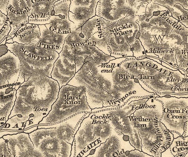 OT02NY20.jpg item:- JandMN : 48.1 Image © see bottom of page |
|
|
|
||
| evidence:- | outline view:- Otley 1823 (4th edn 1830) placename:- Pike of Stickle |
|
| source data:- | Print, engraving, outline view, Mountains of Coniston, Langdale, &c. as they appear
from the road between Troutbeck Bridge and Bowness, published by Jonathan Otley, Keswick,
Cumberland et al, 1830.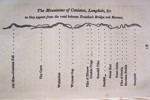 click to enlarge click to enlargeO75E04.jpg p.97 in A Concise Description of the English Lakes, by Jonathan Otley, 4th edition, 1830. "The Mountains of Coniston, Langdale, &c. / as they appear from the road between Troutbeck Bridge and Bowness." "Old Man - Coniston Fell / The Carrs / Wetherlam / Wrynose Gap / Pike of Bliscow / Crinkle Crags / Scawfell Pike / Bowfell / Great End / Great Gable / Pike of Stickle / Harrison Stickle / Paveyark" item:- Armitt Library : A1175.4 Image © see bottom of page |
|
|
|
||
| evidence:- | outline view:- Otley 1823 (8th edn 1849) placename:- Pike of Stickle |
|
| source data:- | Engraving, outline view of mountains, Windermere looking towards the West from the
Road between Troutbeck and Bowness, drawn by T Binns, engraved by O Jewitt, opposite
p.4 of A Descriptive Guide of the English Lakes, by Jonathan Otley, 8th edition, 1849.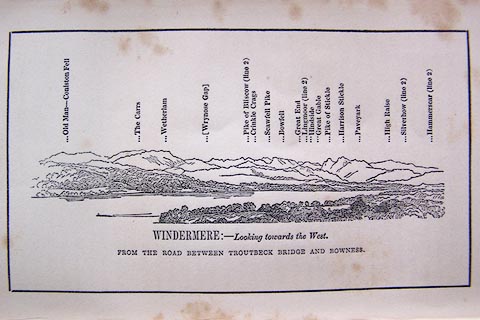 click to enlarge click to enlargeO80E03.jpg item:- Armitt Library : A1180.4 Image © see bottom of page |
|
|
|
||
| evidence:- | outline view:- Otley 1823 (5th edn 1834) |
|
| source data:- | Print, woodcut outline view, The Mountains of Coniston, Langdale, Etc, by Jonathan
Otley, Keswick, Cumberland, 1830.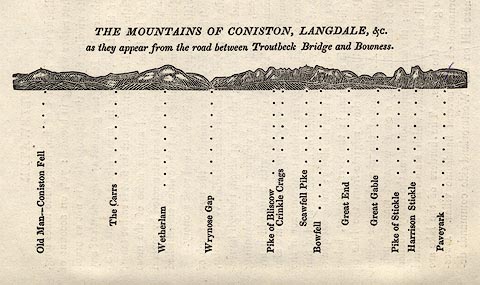 click to enlarge click to enlargeOT2E01.jpg Printed on p.7 of A Concise Description of the English Lakes, by Jonathan Otley, 5th edition, 1834. "THE MOUNTAINS OF CONISTON, LANGDALE, &c. as they appear from the road between Troutbeck Bridge and Bowness." Mountains in the view are listed:- "Old Man - Coniston Fell / The Carrs / Wetherlam / Wrynose Gap / Pike of Bliscow / Crinkle Crags / Scawfell Pike / Bowfell / Great End / Great Gable / Pike of Stickle / Harrison Stickle / Paveyark" item:- JandMN : 48.2 Image © see bottom of page |
|
|
|
||
| evidence:- | descriptive text:- Otley 1823 (5th edn 1834) |
|
| source data:- | Guide book, A Concise Description of the English Lakes, the
mountains in their vicinity, and the roads by which they may be
visited, with remarks on the mineralogy and geology of the
district, by Jonathan Otley, published by the author, Keswick,
Cumberland now Cumbria, by J Richardson, London, and by Arthur
Foster, Kirkby Lonsdale, Cumbria, 1823; published 1823-49,
latterly as the Descriptive Guide to the English Lakes. goto source Page 74:- "... Pike of Stickle, and Harrison Stickle, are by their peculiar form distinguished at a great distance. They afford some good views to the south east: but being encompassed on other sides by higher mountains, the prospect is somewhat limited. ... the Pike of Stickle has the advantage of catching, through an opening in the hills, a view of the lake of Bassenthwaite, and the mountain Skiddaw ..." |
|
|
|
||
| evidence:- | outline view:- Martineau 1855 |
|
| source data:- | Print, engraving, outline view, Mountains on the West Side of Windermere, drawn by
L Aspland, engraved by W Banks, Edinburgh, published by John Garnett, Windermere,
Westmorland, and by Whittaker and Co, London, 1855.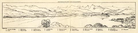 click to enlarge click to enlargeMNU102.jpg Folded in opposite p.7 in A Complete Guide to the English Lakes, by Harriet Martineau. "MOUNTAINS ON THE WEST SIDE OF WINDERMERE" "L Aspland Delt. / W Banks Sc Edinburgh." The view is captioned, numbers referring to mountains in the image:- "1 Coniston Old Man 1a Carrs 2 Wetherlam 3 Wrynose Gap 4 Crinkle Crags 5 Pike of Bliscow 6 Scawfell Pike 7 Bowfell 8 Hanging Knotts 9 Glaramara 10 Great End 11 Pike of Stickle 12 Harrison Stickle 13 Paveyark 14 Lingmoor 15 High Raise 16 Silver How 17 Loughrigg Fell 18 Ullscarth" item:- Armitt Library : A1159.2 Image © see bottom of page |
|
|
|
||
| evidence:- | outline view:- Martineau 1855 |
|
| source data:- | Print, engraving, outline view, Mountains seen a little beyond Rydal Mount, drawn
by L Aspland, engraved by W Banks, Edinburgh, published by John Garnett, Windermere,
Westmorland, and by Whittaker and Co, London, 1855.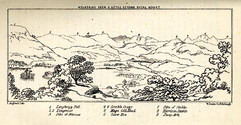 click to enlarge click to enlargeMNU109.jpg Opposite p.64 in A Complete Guide to the English Lakes, by Harriet Martineau. "MOUNTAINS SEEN A LITTLE BEYOND RYDAL MOUNT." "L Aspland Delt. / W Banks Sc Edinr." The view is captioned, numbers referring to mountains in the image:- "1 Loughrigg Fell, 2 Lingmoor, 3 Pike of Bliscow, 4 Crinkle Crags, 5 Meg's Gill Head, 6 Silver How, 7 Pike of Stickle, 8 Harrison Stickle, 9 Pavey Ark" item:- Armitt Library : A1159.9 Image © see bottom of page |
|
|
|
||
| evidence:- | old photograph:- Bell 1880s-1940s |
|
| source data:- | Photograph, sepia, Great Langdale, Westmorland, by Herbert Bell, photographer, Ambleside,
Westmorland, 1890s.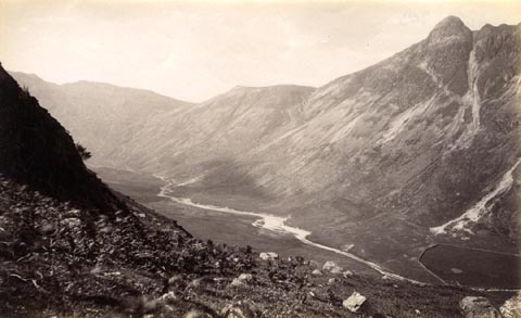 click to enlarge click to enlargeHB0640.jpg Mickleden Beck in the valley bottom; Pike of Stickle on the right, Stake Pass vaguely recognizable towards the left. item:- Armitt Library : ALPS303 Image © see bottom of page |
|
|
|
||
| evidence:- | outline view:- Jenkinson 1875 placename:- Pike o' Stickle |
|
| source data:- | Print, lithograph, outline view, Panoramic Sketches from Skiddaw, Cumberland, by Edwin
A Pettitt, London, published by Edward Stanford, 55 Charing Cross, London, 1875. click to enlarge click to enlargeJk01E2.jpg "... Pike O' Stickle ..." item:- JandMN : 28.8 Image © see bottom of page |
|
|
|
||
| evidence:- | outline view:- Black 1856 (23rd edn 1900) placename:- Pike of Stickle |
|
| source data:- | Print, lithograph, Outline Views, Windermere - Mountains as seen from the North End
of Belle Isle, Windermere, and Mountains as seen from Biscay How, Bowness, by J Flintoft,
Keswick, Cumberland, engraved by R Mason, Edinburgh, Lothian, about 1900.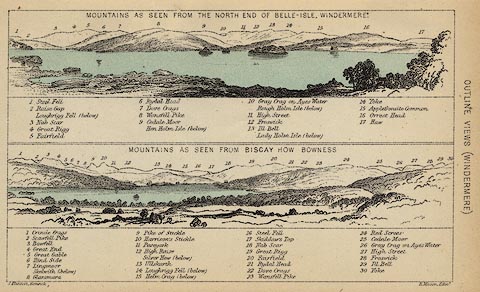 click to enlarge click to enlargeBC08E1.jpg "... 9 Pike of Stickle ..." item:- JandMN : 37.4 Image © see bottom of page |
|
|
|
||
| evidence:- | outline view:- Black 1841 (3rd edn 1846) placename:- Pike of Stickle |
|
| source data:- | Print, engraving, outline view, Mountains as seen from the North End of Belle Isle,
Windermere, and Mountains as seen from Bisket How, Bowness, by J Flintoft, Keswick,
Cumberland, engraved by R Mason, Edinburgh, about 1844.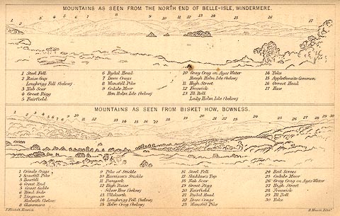 click to enlarge click to enlargeBC02E1.jpg "... 9 Pike of Stickle ..." item:- JandMN : 32.3 Image © see bottom of page |
|
|
|
||
| evidence:- | outline view:- Tattersall 1836 (version 1869) placename:- Pike o'Stickle |
|
| source data:- | Print, hand coloured, Valley of the Stake, Mickleden etc, Westmorland, drawn by George
Tattersall, 1836, engraved by W F Topham, published by T J Allman, 463 Oxford Street,
London, 1869.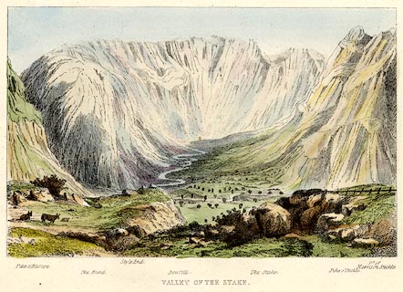 click to enlarge click to enlargeTAT204.jpg Included in The Lakes of England, by W F Topham. printed at bottom:- "VALLEY OF THE STAKE." printed at bottom:- "Pike o'Bliscoe. / The Band. / Style End. / Bowfell. / The Stake. Pike o'Stickle. / Pt. of Harrison Stickle." item:- Armitt Library : A1067.4 Image © see bottom of page |
|
|
|
||
| evidence:- | outline view:- Tattersall 1836 placename:- Pike o'Stickle |
|
| source data:- | Print, engraving, Great Langdale, Westmorland, drawn by George Tattersall, engraved
by W F Topham, published by Sherwood and Co, Paternoster Row, London, about 1836.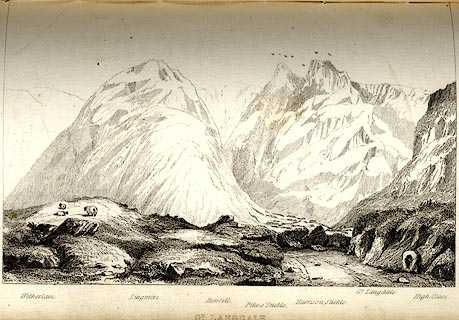 click to enlarge click to enlargeTAT112.jpg The print is captioned with mountain names and acts as an outline view. Tipped in opposite p.46 of The Lakes of England, by George Tattersall. printed at bottom:- "GT. LANGDALE." printed at bottom left to right:- "Wetherlam. / Lingmire. / Bowfell. / Pike o'Stickle. / Harrison Stickle. / Gt. Langdale. / High Close." item:- Armitt Library : A1204.13 Image © see bottom of page |
|
|
|
||
| evidence:- | outline view:- Tattersall 1836 placename:- Pike o'Stickle |
|
| source data:- | Print, engraving, Valley of The Stake, Mickleden, Westmorland, drawn by George Tattersall,
engraved by W F Topham, published by Sherwood and Co, Paternoster Row, London, about
1836.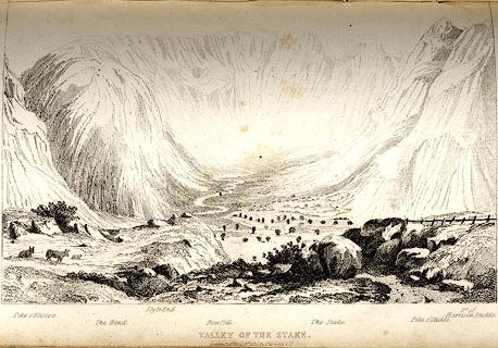 click to enlarge click to enlargeTAT109.jpg The print is captioned with mountain names and acts as an outline view. Tipped in opposite p.42 of The Lakes of England, by George Tattersall. printed at bottom:- "VALLEY OF THE STAKE. / London Pubd. April 15th. 1836, by Sherwood &Co." printed at bottom left to right:- "Pike o'Bliscoe. / The Band. / Style End. / Bowfell. / The Stake. / Pike o'Stickle. / Pt. of Harrison Stickle." item:- Armitt Library : A1204.10 Image © see bottom of page |
|
|
|
||
 BNG79.jpg (taken 26.2.2007)  Click to enlarge BRW49.jpg (taken 11.11.2009) 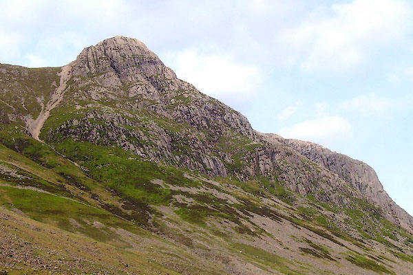 BPF66.jpg (taken 20.5.2008) 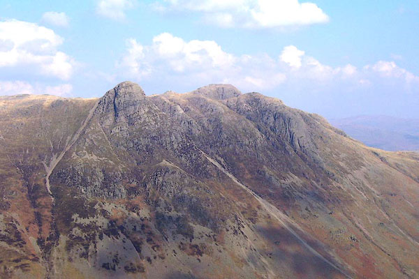 BNL50.jpg (taken 26.3.2007) 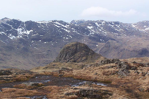 BSI92.jpg (taken 23.3.2010) 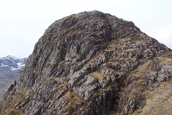 BSI93.jpg (taken 23.3.2010) |
||
|
|
||
Lakes Guides menu.