 Old Cumbria Gazetteer
 |
 |
|
| Piel Island, Barrow-in-Furness | ||
| Piel Island | ||
| Peel Island | ||
| civil parish:- | Barrow-in-Furness (formerly Lancashire) | |
| county:- | Cumbria | |
| locality type:- | island | |
| coordinates:- | SD23246377 | |
| 1Km square:- | SD2363 | |
| 10Km square:- | SD26 | |
|
|
||
| evidence:- | old map:- Lloyd 1573 placename:- Pyle of Foudray, The |
|
| source data:- | Map, hand coloured copper plate engraving, Angliae Regni,
Kingdom of England, with Wales, scale about 24 miles to 1 inch, authored by Humphrey
Lloyd, Denbigh, Clwyd, drawn and engraved
by Abraham Ortelius, Netherlands, 1573. click to enlarge click to enlargeLld1Cm.jpg "The pyle of foudray" item:- Hampshire Museums : FA1998.69 Image © see bottom of page |
|
|
|
||
| evidence:- | poem:- Drayton 1612/1622 text placename:- Pyle of Fouldra |
|
| source data:- | Poem, Poly Olbion, by Michael Drayton, published by published by
John Marriott, John Grismand and Thomas Dewe, and others?
London, part 1 1612, part 2 1622. goto source goto sourcepage 136:- "... Against his [Neptune's] boystrous shocks, which this defensive Isle Of Walney still assayle, that shee doth scorne the while, Which to assist her hath the Pyle of Fouldra set, And Fulney at her backe, a pretty Insuley, Which all their forces bend, their Furnesse safe to keep: ..." |
|
|
|
||
| evidence:- | old text:- Mackenzie 1776 |
|
| source data:- | Charts, and sailing directions, Nautical Descriptions of the
West Coast of Great Britain, Bristol Channel to Cape Wrath, by
Murdoch Mackenzie, published London, 1776. goto source Page 18:- "... ..." "To sail into Piel-of-Foudray from the S.; first make the old castle on that Island ... steer ... and steer for the E. side of Piel-of-Foudray Island, giving the S. end of it a birth of a cable's-length; anchor in the bight of the Island, on four fathoms at high-water, a cable's-length from the high-water mark, when the house bears S. by W. where you will ground before low-water: ..." |
|
|
|
||
| evidence:- | descriptive text:- West 1778 (11th edn 1821) placename:- Isle of Foudry & Foudry, Isle of |
|
| source data:- | Guide book, A Guide to the Lakes, by Thomas West, published by
William Pennington, Kendal, Cumbria once Westmorland, and in
London, 1778 to 1821. goto source Addendum; Mr Gray's Journal, 1769 Page 217:- "[looking from Lancaster] [Peel-]castle on the isle of Foudry, which lies off its southern extremity. ..." |
|
|
|
||
| evidence:- | old map:- West 1784 map |
|
| source data:- | Map, hand coloured engraving, A Map of the Lakes in Cumberland,
Westmorland and Lancashire, scale about 3.5 miles to 1 inch,
engraved by Paas, 53 Holborn, London, about 1784.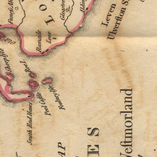 Ws02SD26.jpg item:- Armitt Library : A1221.1 Image © see bottom of page |
|
|
|
||
| evidence:- | old map:- Otley 1818 |
|
| source data:- | Map, uncoloured engraving, The District of the Lakes,
Cumberland, Westmorland, and Lancashire, scale about 4 miles to
1 inch, by Jonathan Otley, 1818, engraved by J and G Menzies,
Edinburgh, Scotland, published by Jonathan Otley, Keswick,
Cumberland, et al, 1833.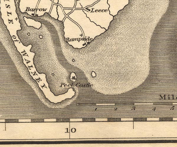 OT02SD26.jpg item:- JandMN : 48.1 Image © see bottom of page |
|
|
|
||
| evidence:- | old map:- Ford 1839 map placename:- Pile of Foudry |
|
| source data:- | Map, uncoloured engraving, Map of the Lake District of
Cumberland, Westmoreland and Lancashire, scale about 3.5 miles
to 1 inch, published by Charles Thurnam, Carlisle, and by R
Groombridge, 5 Paternoster Row, London, 3rd edn 1843.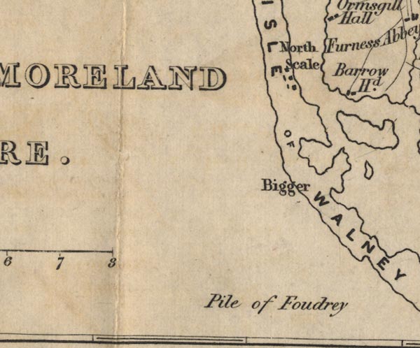 FD02SD16.jpg "Pile of Foudry" The label lying about in the sea, near no feature. item:- JandMN : 100.1 Image © see bottom of page |
|
|
|
||
| evidence:- | old map:- Garnett 1850s-60s H placename:- Peel |
|
| source data:- | Map of the English Lakes, in Cumberland, Westmorland and
Lancashire, scale about 3.5 miles to 1 inch, published by John
Garnett, Windermere, Westmorland, 1850s-60s. GAR2SD26.jpg "Peel" island item:- JandMN : 82.1 Image © see bottom of page |
|
|
|
||
| evidence:- | old print:- Payn 1867 placename:- Piel Island |
|
| source data:- | Print, uncoloured engraving, Piel Castle, Piel Island, Barrow-in-Furness, Lancashire,
by T L Aspland, engraved by Greenaway, published by J Garnett, Windermere, Westmorland,
1867.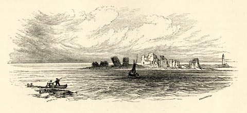 click to enlarge click to enlargePN0342.jpg On p.79 of The Lakes in Sunshine, text by James Payn. printed at lower right:- "GREENAWAY Sc" item:- Fell and Rock Climbing Club : 184.42 Image © see bottom of page |
|
|
|
||
| evidence:- | old print:- Barber 1873 |
|
| source data:- | Print, ?colour lithograph, Piel Castle, published by The
Graphotyping Co, 7 Garrick Street and Simpkin, Marshall and Co,
Stationers' Hall Court, London, and by J Atkinson, King Street,
Ulverston, Cumberland, about 1873.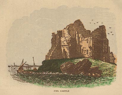 click to enlarge click to enlargeBB1E06.jpg Viewed from the sea. "PIEL CASTLE" item:- JandMN : 69.7 Image © see bottom of page |
|
|
|
||
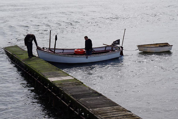 CAG05.jpg Boat to Piel Island (off season when the ferry isn'y running). (taken 4.4.2014) |
||
|
|
||
|
|
||
| hearsay:- |
Lambert Simnel was born of humble parents, in Oxfordshire about 1475. He was educated
by Richard Simon, a priest, taken by him to Ireland. In 1486 he was declared by Yorkist
plotters to be Edward Plantagenet, the son of George the Duke of Clarence. He was
'recognized' by Margaret of Burgundy, and crowned Edward VI, in Dublin, 1487. |
|
| In rebellion against Henry V, Lambert Simnel landed on Piel Island with Martin Swartz
and a small army of german mercenaries. |
||
| The rebellion was stopped by a battle at Stoke-on-Trent where Lambert Simnel was captured.
He was pardoned as being harmless, and lived therafter as a servant. |
||
|
|
||
| story:- |
Once upon a time on occasion, the King of Piel, that is the landlord of the Ship Inn,
carries out a knighting ceremony. An honoured person is seated in the Abbot's Chair,
wearing oilskins and a viking helmet, and holding a viking sword. Having read the
words of an old charter, the victim, sorry, the new knight, is annointed with a gallon
of beer and then has the duty of buying a round of drinks for all. He can, in compensation,
claim a free night's lodging whenever he is shipwrecked on Piel Island. |
|
|
|
||
| story:- |
A 16th century herbal:- |
|
| "THE HERBALL OR GENERALL Historie of Plantes. Gathered by John Gerarde of London Master
in CHIRURGERIE. Imprinted at London by John Norton 1597" |
||
| includes a description of the barnacle tree, that breeds barnacle geese instead of
leavs. |
||
| "... one of the marvels of this land ..." |
||
| In the Orkneys and the north of Scotland are |
||
| "trees whereon do grow certaine shells of a white colour tending to russett, wherein
are contained little living creatures: which shells in time of maturitie doe open,
and out of them grow those little living things, which falling into the water do become
foules, which we call Barnacles; in the North of England, brant Geese; and in Lancashire
tree Geese: but the other that do fall upon the land perish and come to nothing" |
||
| John Gerard claims to have seen with his own eyes, and touched with his own hands,
on the Pile of Foulders, Lancashire, timber from wrecked ships on which grow a froth
which turns to shells |
||
| "in shape like those of the Muskle, but sharper pointed, and of a whitish colour; wherein
is contained a thing in forme like a lace of silke, finely woven as it were together,
of whitish colour, one end whereof is fastned unto the inside of the shell, even as
the fish of Oisters and Muskles are; the other ende is made fast unto the belly of
a rude masse or lumpe, which in time cometh to the shape and forme of a Bird: when
it is perfectly formed, the shell gapeth open, and the first thing that appeareth
is the foresaid lace or strinng; next comes the legs of the Birde hanging out and,
as it groweth greater, it openeth the shell by degrees, til at length it is all come
foorth, and hangeth onely by the bill; in short space after it commeth to full maturitie,
and falleth into the sea, where it gathereth feathers, and groweth to a fowle, bigger
than a Mallard and lesser than a Goose, having blacke legs and bill or beake." |
||
| Gerard, John: 1597: Herball or General History of Plantes: Norton, John (London)::
p.1391 |
||
|
|
||
| Paley and Austin series | ||
| person:- | architect : Paley, Edward G |
|
| person:- | architect : Austin, Hubert J |
|
| date:- | 1875 |
|
| Pilots cottages. |
||
|
|
||
Lakes Guides menu.