Old Cumbria Gazetteer
 |
 |
|
||
| Piel Channel | ||||
| locality:- | Piel Channel area | |||
| civil parish:- | Barrow-in-Furness (formerly Lancashire) | |||
| county:- | Cumbria | |||
| locality type:- | river | |||
| locality type:- | channel | |||
| 1Km square:- | SD2264 (etc) | |||
| 10Km square:- | SD26 | |||
|
|
||||
 Click to enlarge BUW03.jpg (taken 1.7.2011) |
||||
|
|
||||
| evidence:- | old map:- OS County Series (Lan 28 5) placename:- Piel Channel |
|||
| source data:- | Maps, County Series maps of Great Britain, scales 6 and 25
inches to 1 mile, published by the Ordnance Survey, Southampton,
Hampshire, from about 1863 to 1948. |
|||
|
|
||||
| evidence:- | old painting:- Penn 1730s |
|||
| source data:- | Painting, pen and ink and watercolour, A Prospect of the Ruins
of the Castle of Pile of Fouldry and the Adjacent Islands taken
from Ramside, ie Piel Castle etc, Barrow-in-Furness, Lancashire,
by Stephen Penn, 1730s. click to enlarge click to enlargePEN5Msc1.jpg item:- Huntington Art Gallery : 1 Image © see bottom of page |
|||
|
|
||||
| evidence:- | old map:- Garnett 1850s-60s H |
|||
| source data:- | Map of the English Lakes, in Cumberland, Westmorland and
Lancashire, scale about 3.5 miles to 1 inch, published by John
Garnett, Windermere, Westmorland, 1850s-60s.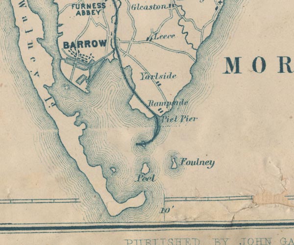 GAR2SD26.jpg area item:- JandMN : 82.1 Image © see bottom of page |
|||
|
|
||||
| evidence:- | old text:- Admiralty 1933 placename:- item:- buoy, Piel Channel; dredger; sea mark; leading line; fog signal; tidal stream |
|||
| source data:- |  goto source goto sourcePage 376:- "Farther north-westward [of Piel Island], the channel, which continues to be very narrow, passes between the drying banks which extend north-eastward from the north-eastern side of Walney island, and those which extend south-westward from the mainland." goto sourcePage 377:- "A least depth of 3 3/4 feet (1m1) is maintained by dredging in a channel, 400 feet (121m9) wide, between Piel harbour and the docks." "Winds. - Caution. - South-westerly and westerly winds, which cause considerable sea in the entrance channel, are the most dangerous winds." "Strong south-westerly and westerly gales increase the depths in Walney channel; easterly winds have the opposite effect." "Dredging. - Signals. - Dredging is generally in progress in the channel between Piel harbour and the docks." "A black ball is displayed, by day, on the side of the dredger which is clear for vessels to pass; at night, three white lights are exhibited in the form of a triangle, and a fourth white light 6 feet (1m8) below one angle of the triangle, on the side which is clear for vessels to pass." "The ordinary fog signal for a vessel not under way is sounded when required." "Vessels should pass the dredger at a moderate speed." "Lights. - Beacons. - A light is exhibited, at an elevation of 70 feet (21m3), from a stone tower, 60 feet (18m3) in height, situated about 1 3/4 cables north-westward of South East point, Walney island." "A light is exhibited, at an elevation of 26 feet (7m9), from an iron pile structure, 40 feet (12m2) in height, situated on the ledge off Haws point and about 3 cables east-north-eastward of Walney lighthouse." "The channel through Piel bar, and up to the pile lighthouses described below, is indicated by three sets of leading lights. The first set, numbered 1 and 2, is situated on the southern and south-eastern sides of Foulney island; the second set, numbered 3 and 4, is situated on Rampside sands, which lie northward of Foulney island, between it and the mainland near Rampside, nearly one mile north-north-eastward of Roa island; and the third set, numbered 5 and 6, on Biggar sands (Lat. 54~ 06' N., Long. 3~ 14' W.), the south-western side of Barrow channel, south-westward of Ramsden dock entrance." "The front light of each set bears an odd number, and is exhibited, at an elevation of 20 feet (6m1), from the summit of a pile structure diagonally boarded and painted black; the rear lights are exhibited, at different heights, from the summits of square red brick columns, the faces of which are of white bricks (see sketches on chart 3164). The first rear light is exhibited at an elevation of 38 feet (11m6), the second at 46 feet (14m0), and the third at 61 feet (18m6). The line of bearing of Nos.1 and 2, is 041~; of Nos.3 and 4, 006; and of Nos.5 and 6, 298~." "The limits of the channel for the outer reach are indicated by two sets of beacons, those northward and north-eastward, respectively, of No.1 light being painted black with square topmarks, and those westward and southward of No.2 light, white with red disk topmarks." "There are also a number of beacons, for the guidance of dredgers only, which are liable to be moved at any time." "A light is exhibited, at an elevation of 26 feet (7m9), from East pile, 55 feet (16m8) in height, which is situated on the northern side of the channel about 1 1/2 miles west-north-westward of Roa island." "A light is exhibited, at an elevation of 26 feet (7m9), from West" goto sourcePage 378:- "pile, 48 feet (14m6) in height, situated on the north-western side of the channel about 4 1/2 cables north-westward of East pile." "Training banks. ..." "Buoyage. - The approaches to Barrow docks are buoyed in accordance with the uniform system of buoyage for the United Kingdom, described on page 21, the colour of the starboard hand buoys being red, and of port buoys black." "A black light-and-bell-buoy, marked "Lightning knoll," which exhibits a white flashing light having a short flash every two and a half seconds, is moored about 2 cables westward of the southern end of Lightning knoll." "A black can buoy, with a staff and cage topmark and marked "Hilpsford," is moored southward of Hilpsford shoal, which is situated at south-western corner of the bank, with depths of less than 2 fathoms (3m7) over it, that extends about 1 1/4 miles south-westward from Hilpsford point (Lat. 54~ 03' N., Long. 3~ 12' W.)." "A black can light-buoy, marked "Halfway," which exhibits a red flashing light having a short flash every ten seconds, is moored near the north-western edge of the entrance channel, about 1 1/4 miles southward of Hilpsford point." "A black can buoy, marked "Bar Outer," is moored about 200 feet (61m0) north-westward of the line of the leading lights at about 10 1/2 cables south-south-westward of Walney lighthouse." "A black can light-buoy, marked "Bar," which exhibits a white flashing light having a short flash every ten seconds, is moored about 4 1/2 cables south-south-eastward of Walney lighthouse, on the western side of the bend in the dredged channel through the bar, close north-westward of the leading line, and marking the point where the course has to be altered." "A square black buoy, marked "Groyne," is moored south-south-eastward of the end of the groyne which extends 1 1/2 cables southward from South East point." "A red conical buoy, with a globe topmark and marked "Seldom Seen," is moored near the southern end of Seldom Seen." "The buoys marking each side of the channel above Piel are moored just outside the dredged channel, and are numbered from seaward. No.1 port hand buoy is a light-buoy; it is moored at the north-" goto sourcePage 379:- "[north-]eastern extremity of Coup scar, and exhibits a white flashing light having a short flash every two and a half seconds." "No.1 starboard hand buoy is also alight-buoy; it is moored at the southern extremity of Head scar, about 4 cables westward of the look-out tower on Roa island, and exhibits a red flashing light having a short flash every nine seconds." "An un-numbered black can buoy, with a globe topmark and marked Elbow, is moored, on the south-western side of the channel, about midway between Nos.7 and 8 port hand buoys." "The buoys are shifted, occasionally, as alterations are effected by the dredging operations in progress; additional buoys are also placed where required; such buoys being usually distinguished by topmarks." "Tide Gauge. - A tide gauge is attached to the East Pile light structure." "Tidal streams. - The tidal streams at the Lightning Knoll light-and-bell-buoy (Lat. 54~ 00' N., Long. 3~ 14' W.) are rotatory, and not strong. The greatest strength is at 2 hours after high water at Liverpool, when the stream runs from 1 1/2 to 2 1/2 knots between west-north-westward and westward, and again at half flood, when its rate varies between one and 1 1/2 knots, and its direction between east-south-eastward and eastward." "The northern end of Walney island is separated from the mainland by a narrow channel which is practically dry until half tide, so that the stream which fills the channel eastward of the island comes round its southern end." "In Piel harbour the stream attains a maximum rate of 3 1/2 knots, at springs, between Roa and Walney islands. In the harbour it turns about the time of high water at Liverpool; in the channel, near East Pile lighthouse, the northern stream continues for half an hour longer, and in front of Ramsden dock it runs for about 1 1/2 hours after high water at Liverpool; here it reaches its greatest strength about half-flood, gradually losing its force till it turns southward." "..." "Directions. - Vessels waiting to enter the harbour should remain south-westward of Lightning Knoll light-and-bell-buoy, in depths of not less than 5 fathoms (9m1)." "As stated above, local knowledge is necessary for entering." "Approach from the south-westward with Walney lighthouse bearing 032~, which will lead up to Lightning Knoll light-and-bell-buoy. Pass close northward of this buoy, and steer in with Nos. 1 and 2 light-beacons in line, bearing 041~. Care is necessary, as both the flood and ebb streams set across the line of the leading marks." goto sourcePage 380:- "When abreast of Bar light-buoy, bring Nos.3 and 4 light-beacons into line, bearing 006~; this turn is somewhat sharp, and, when entering on the flood, it is necessary to keep No.4 light-beacon open a little westward of No.3 light-beacon, in order to avoid being set on to the eastern flats. When passing Haws point, No.4 light-beacon must be opened a little eastward off No.3 light-beacon, in order to avoid the extension of the spit eastward of that point, and, as soon as the point has been passed, the light-beacons must be brought into line once more." "When abreast of the centre of Piel island (Lat. 54~ 04' N., Long. 3~ 10' W.), alter course gradually westward, to bring Nos.5 and 6 light-beacons into line, bearing 298~, and anchor in Piel harbour if necessary. Small craft usually lie aground on the banks." "..." |
|||
|
|
||||
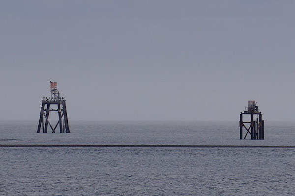 CAG04.jpg Sea marks SE of Barrow Lifeboat Station. (taken 4.4.2014) |
||||
|
|
||||
| places:- |
|
|||
|
||||
Lakes Guides menu.