 Old Cumbria Gazetteer
 |
 |
|
| Moricambe, Holme East Waver | ||
| runs into:- |  Solway Firth Solway Firth |
|
|
|
||
| Moricambe | ||
| Moricambe Bay | ||
| civil parish:- | Holme East Waver (formerly Cumberland) | |
| county:- | Cumbria | |
| locality type:- | bay | |
| locality type:- | foreshore | |
| coordinates:- | NY16535703 (etc etc) | |
| 1Km square:- | NY1657 | |
| 10Km square:- | NY15 | |
|
|
||
| evidence:- | old map:- OS County Series (Cmd 21 6) placename:- Moricambe |
|
| source data:- | Maps, County Series maps of Great Britain, scales 6 and 25
inches to 1 mile, published by the Ordnance Survey, Southampton,
Hampshire, from about 1863 to 1948. "MORICAMBE" "High Water Mark of Ordinary Spring Tides" |
|
|
|
||
| evidence:- | old map:- Speed 1611 (Cmd) |
|
| source data:- | Map, hand coloured engraving, Cumberland and the Ancient Citie
Carlile Described, scale about 4 miles to 1 inch, by John Speed,
1610, published by J Sudbury and George Humble, Popes Head
Alley, London, 1611-12.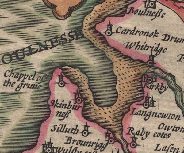 SP11NY15.jpg bay item:- private collection : 16 Image © see bottom of page |
|
|
|
||
| evidence:- | old map:- Jansson 1646 |
|
| source data:- | Map, hand coloured engraving, Cumbria and Westmoria, ie
Cumberland and Westmorland, scale about 3.5 miles to 1 inch, by
John Jansson, Amsterdam, Netherlands, 1646.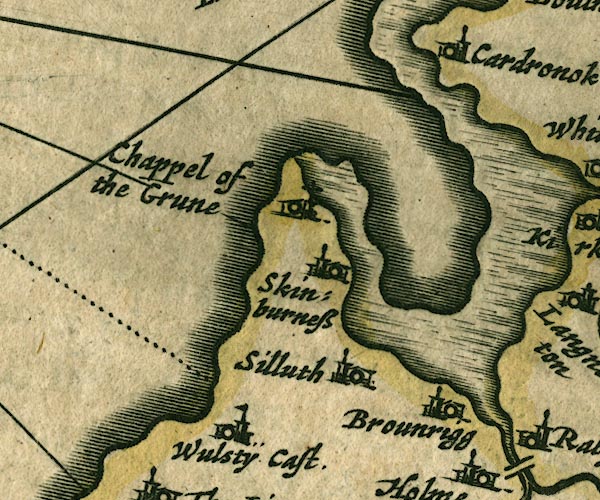 JAN3NY15.jpg item:- JandMN : 88 Image © see bottom of page |
|
|
|
||
| evidence:- | old map:- Sanson 1679 |
|
| source data:- | Map, hand coloured engraving, Ancien Royaume de Northumberland
aujourdhuy Provinces de Nort, ie the Ancient Kingdom of
Northumberland or the Northern Provinces, scale about 9.5 miles
to 1 inch, by Nicholas Sanson, Paris, France, 1679. click to enlarge click to enlargeSAN2Cm.jpg bay item:- Dove Cottage : 2007.38.15 Image © see bottom of page |
|
|
|
||
| evidence:- | old map:- Seller 1694 (Cmd) |
|
| source data:- | Map, uncoloured engraving, Cumberland, scale about 12 miles to 1
inch, by John Seller, 1694. click to enlarge click to enlargeSEL9.jpg bay item:- Dove Cottage : 2007.38.89 Image © see bottom of page |
|
|
|
||
| evidence:- | old map:- Morden 1695 (EW) |
|
| source data:- | Map, hand coloured engraving, England, including Wales, scale
about 27 miles to 1 inch, by Robert Morden, published by Abel
Swale Awnsham and John Churchil, London, about 1695. click to enlarge click to enlargeMRD3Cm.jpg bay item:- JandMN : 339 Image © see bottom of page |
|
|
|
||
| evidence:- | old map:- Morden 1695 (Cmd) placename:- Moricambo |
|
| source data:- | Map, uncoloured engraving, Cumberland, scale about 4 miles to 1
inch, by Robert Morden, 1695, published by Abel Swale, the
Unicorn, St Paul's Churchyard, Awnsham, and John Churchill, the
Black Swan, Paternoster Row, London, 1695-1715.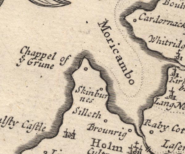 MD12NY15.jpg "Moricambo" Sea area, bay. item:- JandMN : 90 Image © see bottom of page |
|
|
|
||
| evidence:- | old text:- Gents Mag placename:- Cardronac Bay item:- smuggling |
|
| source data:- | Magazine, The Gentleman's Magazine or Monthly Intelligencer or
Historical Chronicle, published by Edward Cave under the
pseudonym Sylvanus Urban, and by other publishers, London,
monthly from 1731 to 1922. goto source Gentleman's Magazine 1748 p.291 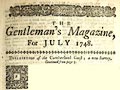 click to enlarge click to enlargeG748E04.jpg "... we come to Cardronac bay, which is a very dangerous one, being full of shifting quicksands, by reason of the rivers and land waters; these, after rains, hurry the sand into a loose sludge, which must be wash'd with several tides before it consolidates afresh, so that no traveller, or even the inhabitants, can pass it with certainty at all times.-" "This bay is by some suppos'd the Mori-cambe of Ptolemy, ... There has been an old castle at the cote of Skinburn-naze, probably to guard the bay; a deep creek flows up to it rendering it navigable, so that brandy sloops drive on a strong trade here, because of the impossibility of an officer getting at them, especially from the Cardronac side." |
|
|
|
||
| evidence:- | old map:- Bowen and Kitchin 1760 placename:- Moricambe |
|
| source data:- | Map, hand coloured engraving, A New Map of the Counties of
Cumberland and Westmoreland Divided into their Respective Wards,
scale about 4 miles to 1 inch, by Emanuel Bowen and Thomas
Kitchin et al, published by T Bowles, Robert Sayer, and John
Bowles, London, 1760.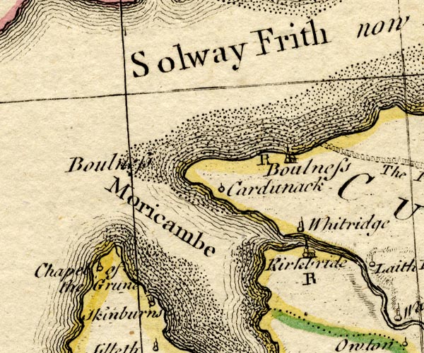 BO18NY15.jpg "Moricambe" sea area, bay item:- Armitt Library : 2008.14.10 Image © see bottom of page |
|
|
|
||
| evidence:- | old map:- Donald 1774 (Cmd) placename:- Moricambe |
|
| source data:- | Map, hand coloured engraving, 3x2 sheets, The County of Cumberland, scale about 1
inch to 1 mile, by Thomas Donald, engraved and published by Joseph Hodskinson, 29
Arundel Street, Strand, London, 1774.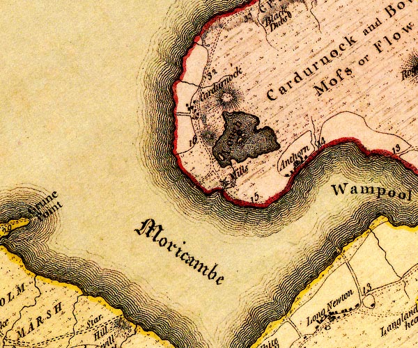 D4NY15NE.jpg "Moricambe" bay; lettered in English Black Letter item:- Carlisle Library : Map 2 Image © Carlisle Library |
|
|
|
||
| evidence:- | probably old text:- Camden 1789 placename:- Moricambe |
|
| source data:- | Book, Britannia, or A Chorographical Description of the Flourishing Kingdoms of England,
Scotland, and Ireland, by William Camden, 1586, translated from the 1607 Latin edition
by Richard Gough, published London, 1789. goto source Page 172:- "..." "The shore proceeding strait from hence [Maryport], presently forms such a bending winding bay, that it seems to be MORICAMBE, which Ptolemy places hereabouts. The situation and name of the place agree; for the aestuary bends in, and Moricambe signifies in British crooked sea. On this David I. king of Scotland founded Holme, or as it is commonly called Holme Cultrain abbey; ..." |
|
|
|
||
| evidence:- | old map:- Cooke 1802 placename:- Wampool |
|
| source data:- | Map, Cumberland, scale about 15.5 miles to 1 inch, by George
Cooke, 1802, bound in Gray's New Book of Roads, 1824, published
by Sherwood, Jones and Co, Paternoster Road, London, 1824. click to enlarge click to enlargeGRA1Cd.jpg "[W]ampool" estuary item:- Hampshire Museums : FA2000.62.2 Image © see bottom of page |
|
|
|
||
| evidence:- | old map:- Cooper 1808 |
|
| source data:- | Map, uncoloured engraving, Cumberland, scale about 10.5 miles to
1 inch, drawn and engraved by Cooper, published by R Phillips,
Bridge Street, Blackfriars, London, 1808. click to enlarge click to enlargeCOP3.jpg bay item:- JandMN : 86 Image © see bottom of page |
|
|
|
||
| evidence:- | possibly old map:- Wallis 1810 (Cmd) placename:- Wampool |
|
| source data:- | Road map, hand coloured engraving, Cumberland, scale about 16
miles to 1 inch, by James Wallis, 77 Berwick Stree, Soho,
London, 1810. click to enlarge click to enlargeWL13.jpg "Wampool" bay? item:- Dove Cottage : 2009.81.10 Image © see bottom of page |
|
|
|
||
| evidence:- | old map:- Hall 1820 (Cmd) |
|
| source data:- | Map, hand coloured engraving, Cumberland, scale about 21 miles
to 1 inch, engraved by Sidney Hall, published by S Leigh, 18
Strand, London, 1820-31. click to enlarge click to enlargeHA14.jpg bay item:- JandMN : 91 Image © see bottom of page |
|
|
|
||
| evidence:- | old map:- Ford 1839 map placename:- Wampool Bay |
|
| source data:- | Map, uncoloured engraving, Map of the Lake District of
Cumberland, Westmoreland and Lancashire, scale about 3.5 miles
to 1 inch, published by Charles Thurnam, Carlisle, and by R
Groombridge, 5 Paternoster Row, London, 3rd edn 1843.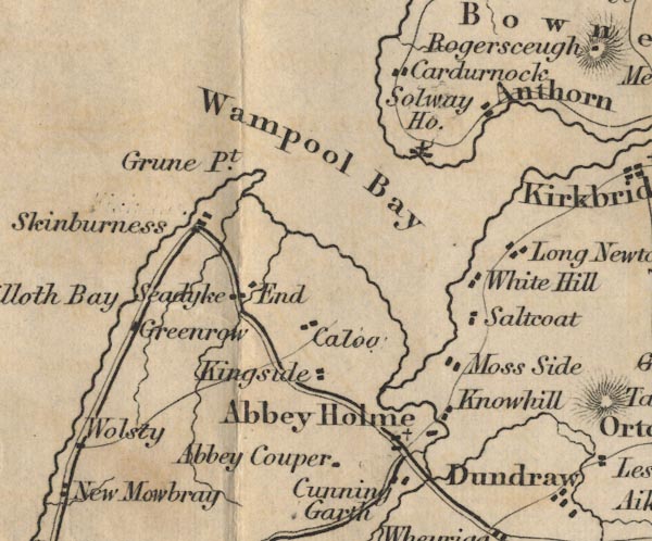 FD02NY15.jpg "Wampool Bay" Sea area. item:- JandMN : 100.1 Image © see bottom of page |
|
|
|
||
| evidence:- | old map:- Garnett 1850s-60s H |
|
| source data:- | Map of the English Lakes, in Cumberland, Westmorland and
Lancashire, scale about 3.5 miles to 1 inch, published by John
Garnett, Windermere, Westmorland, 1850s-60s. GAR2NY15.jpg bay item:- JandMN : 82.1 Image © see bottom of page |
|
|
|
||
Lakes Guides menu.