 Old Cumbria Gazetteer
 |
 |
|
| milestone, Stainmore (3) | ||
| site name:- | road, Brough to Middleton-in-Teesdale | |
| civil parish:- | Stainmore (formerly Westmorland) | |
| county:- | Cumbria | |
| locality type:- | milestone | |
| coordinates:- | NY82441946 | |
| 1Km square:- | NY8219 | |
| 10Km square:- | NY81 | |
|
|
||
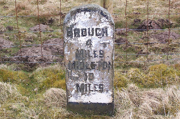 BLX42.jpg Inscribed stone:- "BROUGH 4 MILES. / MIDLETON 10 MILES." and hands pointing the way. (taken 21.4.2006) |
||
|
|
||
| evidence:- | old map:- OS County Series (Wmd 17) |
|
| source data:- | Maps, County Series maps of Great Britain, scales 6 and 25
inches to 1 mile, published by the Ordnance Survey, Southampton,
Hampshire, from about 1863 to 1948. "M.S. BROUGH 4" |
|
|
|
||
| evidence:- | database:- Listed Buildings 2010 |
|
| source data:- | courtesy of English Heritage "MILESTONE TO NORTH OF DEADMANGILL BRIDGE / / B6276 / STAINMORE / EDEN / CUMBRIA / II / 73383 / NY8244419464" |
|
| source data:- | courtesy of English Heritage "Milestone; C19. Single stone c3 ft high with segmental top. Edge and carved sans-serif inscription painted black against white background: BROUGH 4 MILES (hand points to right), MIDDLETON 10 MILES (hand points to left)." |
|
|
|
||
 Lakes Guides menu.