 Old Cumbria Gazetteer
 |
 |
|
| Loweswater Mines, Loweswater | ||
| Loweswater Mines | ||
| Loweswater Lead Mine | ||
| Kirkgill Wood Mine | ||
| Batey's Cave | ||
| site name:- | ||
| civil parish:- | Loweswater (formerly Cumberland) | |
| county:- | Cumbria | |
| locality type:- | lead mine | |
| locality type:- | mine | |
| coordinates:- | NY146216 | |
| coordinates:- | NY140208 | |
| 1Km square:- | NY1421 | |
| 1Km square:- | NY1420 | |
| 10Km square:- | NY12 | |
| references:- | Adams, John: 1988: Mines of the Lake District Fells: Dalesman Books (Lancaster, Lancashire)::
ISBN 0 85206 931 6 |
|
|
|
||
| evidence:- | probably descriptive text:- Otley 1823 (5th edn 1834) item:- geology |
|
| source data:- | Guide book, A Concise Description of the English Lakes, the
mountains in their vicinity, and the roads by which they may be
visited, with remarks on the mineralogy and geology of the
district, by Jonathan Otley, published by the author, Keswick,
Cumberland now Cumbria, by J Richardson, London, and by Arthur
Foster, Kirkby Lonsdale, Cumbria, 1823; published 1823-49,
latterly as the Descriptive Guide to the English Lakes. goto source goto sourcePage 154:- "... Veins of lead ore occur in several places; and have been worked between Skiddaw and Saddleback, in Thornthwaite, Newlands, and Buttermere; but one in the parish of Loweswater, and one below the level of Derwent Lake, are the most productive at present in this district." |
|
|
|
||
| evidence:- | old text:- Postlethwaite 1877 (3rd edn 1913) placename:- Loweswater Mines |
|
| source data:- | Book, Mines and Mining in the English Lake District, by John Postlethwaite, Keswick,
published by W H Moss and Sons, Whitehaven, Cumberland now Cumbria, 1877; published
1877-1913. goto source page 106:- "LOWESWATER MINES." "A line drawn on the map, a little to the north of west and south of east, from Stoneycroft in the Vale of Newlands, through Force Crag, to Scale Hill, in the Vale of Lorton, shows that such a line connects the mines at these three places, and other minor mine workings further west, therefore, although owing to long stretches of soil and turf, or scree covered ground, obscuring the vein and making it difficult, if not impossible to trace it all the way, there can be little doubt that all these mines are on one vein. If the line indicated is continued further to the east, from Stoneycroft across Derwentwater, it will be seen that the vein fissure of Catgill, between Walla Crag and Falcon Crag, is on the same line, and that it, too, may be regarded as a continuation of the same vein." "The shaft of Loweswater Mine, on the western side of the river Cocker, opposite Scale Hill, was sunk about 75 or 80 years ago, to a depth of 17 or 18 fathoms, and a considerable extent of ground was excavated and a good deal of ore obtained from it. The timbers of the old workings are now decaying and a part of the surface occasionally falls in. There was a good deal of water in the mine, and a powerful water-wheel was erected to pump the water from it, also to haul the ore to the surface, and propel the dressing machinery." "There is also another parallel vein to the south of Loweswater Valley, between Whiteoak and Highnook Becks, from which some ore was obtained about the time that Loweswater Mine was worked; and another vein still further south, on the west side of Mosedale Beck, beneath Hencombe, also yielded some ore." |
|
|
|
||
| evidence:- | old map:- Postlethwaite 1877 (3rd edn 1913) placename:- Loweswater Mine |
|
| source data:- | Map, uncoloured engraving, Map of the Lake District Mining Field, Westmorland, Cumberland,
Lancashire, scale about 5 miles to 1 inch, by John Postlethwaite, published by W H
Moss and Sons, 13 Lowther Street, Whitehaven, Cumberland, 1877 edn 1913.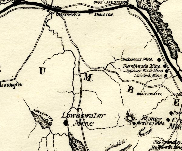 PST2NY12.jpg "Loweswater Mine" mine symbol item:- JandMN : 162.2 Image © see bottom of page |
|
|
|
||
| :- |
Discovered 1816 during drainage work; abandoned 1840s. |
|
| Adams, John: 1988: Mines of the Lake District Fells: Dalesman Books (Lancaster, Lancashire)::
ISBN 0 85206 931 6 |
||
|
|
||
Lakes Guides menu.