 Old Cumbria Gazetteer
 |
 |
|
| Loughrigg, Lakes | ||
| Loughrigg | ||
| civil parish:- | Lakes (formerly Westmorland) | |
| county:- | Cumbria | |
| locality type:- | locality | |
| coordinates:- | NY34530502 (? etc) | |
| 1Km square:- | NY3405 | |
| 10Km square:- | NY30 | |
|
|
||
| evidence:- | old map:- OS County Series (Wmd 26 1) placename:- Rydal and Loughrigg |
|
| source data:- | Maps, County Series maps of Great Britain, scales 6 and 25
inches to 1 mile, published by the Ordnance Survey, Southampton,
Hampshire, from about 1863 to 1948. |
|
|
|
||
| evidence:- | old map:- Saxton 1579 placename:- Langrig |
|
| source data:- | Map, hand coloured engraving, Westmorlandiae et Cumberlandiae Comitatus ie Westmorland
and Cumberland, scale about 5 miles to 1 inch, by Christopher Saxton, London, engraved
by Augustinus Ryther, 1576, published 1579-1645.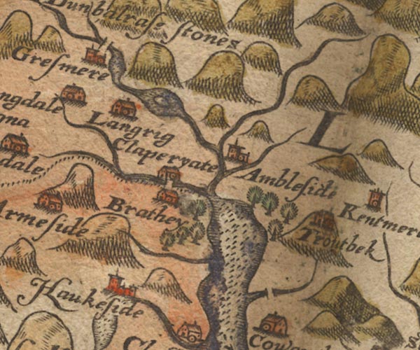 Sax9NY30.jpg Building, symbol for a hamlet, which may or may not have a nucleus. "Langrig" item:- private collection : 2 Image © see bottom of page |
|
|
|
||
| evidence:- | old map:- Speed 1611 (Wmd) placename:- Langrig |
|
| source data:- | Map, hand coloured engraving, The Countie Westmorland and
Kendale the Cheif Towne, scale about 2.5 miles to 1 inch, by
John Speed, 1610, published by George Humble, Popes Head Alley,
London, 1611-12.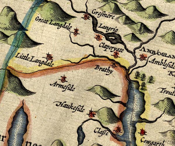 SP14NY30.jpg "Langrig" circle, tower item:- Armitt Library : 2008.14.5 Image © see bottom of page |
|
|
|
||
| evidence:- | old map:- Jansson 1646 placename:- Langrig |
|
| source data:- | Map, hand coloured engraving, Cumbria and Westmoria, ie
Cumberland and Westmorland, scale about 3.5 miles to 1 inch, by
John Jansson, Amsterdam, Netherlands, 1646.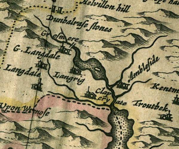 JAN3NY30.jpg "Langrig" Buildings and tower. item:- JandMN : 88 Image © see bottom of page |
|
|
|
||
| evidence:- | hearth tax returns:- Hearth Tax 1675 placename:- Loughrigge and Rydall |
|
| source data:- | Records, hearth tax survey returns, Westmorland, 1674/75. "Loughrigge and Rydall" |
|
|
|
||
| evidence:- | hearth tax returns:- Hearth Tax 1670 placename:- Rydall and Loughrigg |
|
| source data:- | Records, hearth tax returns, exchequer duplicates, Westmorland,
1670. "Rydall &Loughrigg" |
|
|
|
||
| evidence:- | probably old map:- Morden 1695 (Wmd) placename:- Langrig |
|
| source data:- | Map, hand coloured engraving, Westmorland, scale about 2.5 miles to 1 inch, by Robert
Morden, published by Abel Swale, the Unicorn, St Paul's Churchyard, Awnsham, and John
Churchill, the Black Swan, Paternoster Row, London, 1695.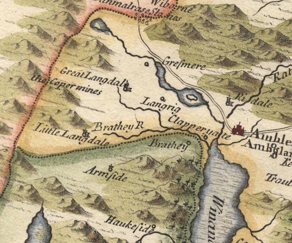 MD10NY30.jpg "Langrig" Circle. item:- JandMN : 24 Image © see bottom of page |
|
|
|
||
| evidence:- | probably old map:- Bowen and Kitchin 1760 placename:- Longbridge |
|
| source data:- | Map, hand coloured engraving, A New Map of the Counties of
Cumberland and Westmoreland Divided into their Respective Wards,
scale about 4 miles to 1 inch, by Emanuel Bowen and Thomas
Kitchin et al, published by T Bowles, Robert Sayer, and John
Bowles, London, 1760.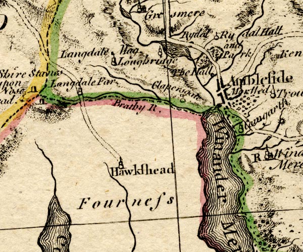 BO18SD29.jpg "Longbridge" circle, tower item:- Armitt Library : 2008.14.10 Image © see bottom of page |
|
|
|
||
| evidence:- | old map:- Jefferys 1770 (Wmd) placename:- Loughrigg |
|
| source data:- | Map, 4 sheets, The County of Westmoreland, scale 1 inch to 1
mile, surveyed 1768, and engraved and published by Thomas
Jefferys, London, 1770.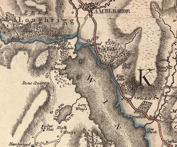 J5NY30SE.jpg "Loughrigg" area item:- National Library of Scotland : EME.s.47 Image © National Library of Scotland |
|
|
|
||
| evidence:- | old print:- Green 1810 (plate 24) item:- Loughrigg Side |
|
| source data:- | Print, soft ground etching, Rocks on Loughrigg Side, Loughrigg, Westmorland, by William
Green, Ambleside, Westmorland, 1808.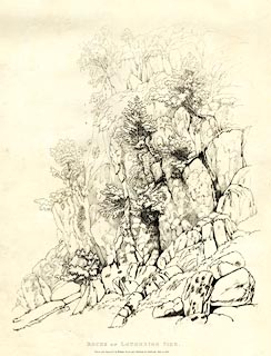 click to enlarge click to enlargeGN1224.jpg Plate 24 in Sixty Studies from Nature, 1810. printed at bottom:- "ROCKS ON LOUGHRIGG SIDE. / Drawn and Engraved by William Green, and Published at Ambleside, June 24, 1808." watermark:- "J WHATMAN / 1813" item:- Armitt Library : A6641.24 Image © see bottom of page |
|
|
|
||
| evidence:- | old drawing:- Aspland 1840s-60s placename:- Loughrigg |
|
| source data:- | Drawing, pencil, Loughrigg, Westmorland, by Theophilus Lindsey Aspland, 1868-69.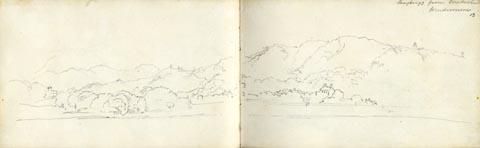 click to enlarge click to enlargeAS0613.jpg "Loughrigg from Waterhead / Windermere" page number "13" item:- Armitt Library : 2008.61.13 Image © see bottom of page |
|
|
|
||
| evidence:- | old photograph:- Bell 1880s-1940s |
|
| source data:- | Photograph, b/w, the road under Loughrigg near Fox How, Ambleside, Westmorland, by
Herbert Bell, Ambleside, Westmorland, 1890s?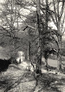 click to enlarge click to enlargeHB0371.jpg item:- Armitt Library : ALPS752 Image © see bottom of page |
|
|
|
||
| evidence:- | old photograph:- Bell 1880s-1940s |
|
| source data:- | Photograph, b/w, the road under Loughrigg, Rydal, Westmorland, by Herbert Bell, Ambleside,
Westmorland, 1890s?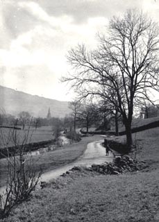 click to enlarge click to enlargeHB0370.jpg item:- Armitt Library : ALPS751 Image © see bottom of page |
|
|
|
||
| evidence:- | old photograph:- Bell 1880s-1940s item:- gate |
|
| source data:- | Photograph, black and white, Under Loughrigg, Ambleside, by Herbert Bell, Ambleside,
Westmorland, 1890s.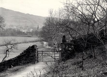 click to enlarge click to enlargeHB0225.jpg item:- Armitt Library : ALPS750 Image © see bottom of page |
|
|
|
||
| evidence:- | old photograph:- Bell 1880s-1940s |
|
| source data:- | Photograph, b/w, the road under Loughrigg near Fox How, Ambleside, Westmorland, by
Herbert Bell, Ambleside, Westmorland, 1890s? click to enlarge HB0371.jpg item:- Armitt Library : ALPS752 Image © see bottom of page |
|
|
|
||
| evidence:- | old photograph:- Bell 1880s-1940s |
|
| source data:- | Photograph, b/w, the road under Loughrigg, Rydal, Westmorland, by Herbert Bell, Ambleside,
Westmorland, 1890s? click to enlarge HB0370.jpg item:- Armitt Library : ALPS751 Image © see bottom of page |
|
|
|
||
| evidence:- | old photograph:- Bell 1880s-1940s item:- gate |
|
| source data:- | Photograph, black and white, Under Loughrigg, Ambleside, by Herbert Bell, Ambleside,
Westmorland, 1890s. click to enlarge HB0225.jpg item:- Armitt Library : ALPS750 Image © see bottom of page |
|
|
|
||
 Lakes Guides menu.