 Old Cumbria Gazetteer
 |
 |
|
| Lincolns Inn Bridge, Firbank | ||
| Lincolns Inn Bridge | ||
| site name:- | Lune, River | |
| locality:- | Bridge End | |
| civil parish:- | Firbank (formerly Westmorland) | |
| civil parish:- | Sedbergh (formerly Yorkshire) | |
| county:- | Cumbria | |
| locality type:- | bridge | |
| coordinates:- | SD63179227 | |
| 1Km square:- | SD6392 | |
| 10Km square:- | SD69 | |
|
|
||
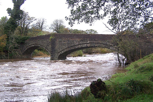
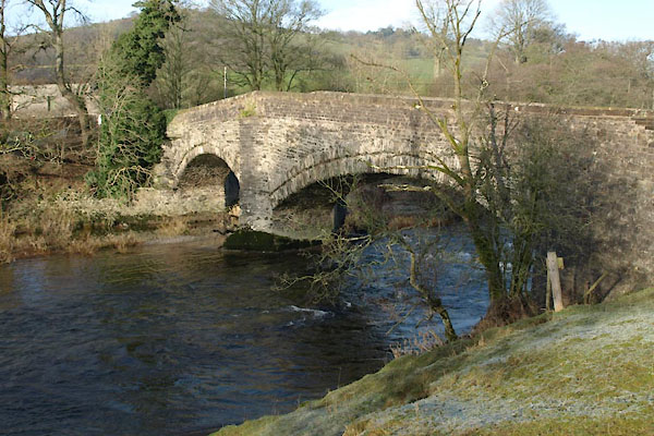 BVU51.jpg (taken 13.1.2012) 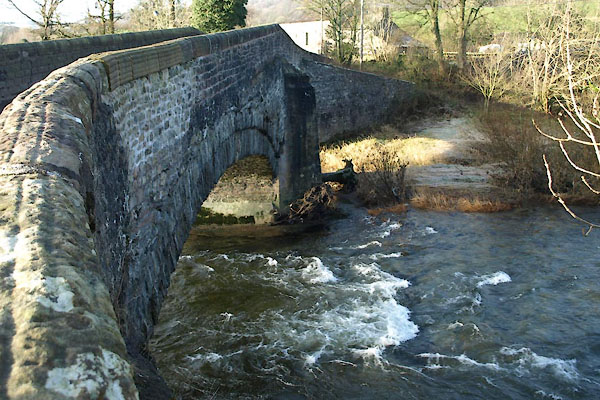 BVU52.jpg (taken 13.1.2012) |
||
|
|
||
| evidence:- | old map:- OS County Series (Wmd 40 5) placename:- Lincoln's Inn Bridge |
|
| source data:- | Maps, County Series maps of Great Britain, scales 6 and 25
inches to 1 mile, published by the Ordnance Survey, Southampton,
Hampshire, from about 1863 to 1948. |
|
|
|
||
| evidence:- | old map:- Jefferys 1770 (Wmd) placename:- Lincolns Inn Bridge |
|
| source data:- | Map, 4 sheets, The County of Westmoreland, scale 1 inch to 1
mile, surveyed 1768, and engraved and published by Thomas
Jefferys, London, 1770.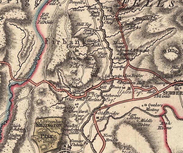 J5SD69SW.jpg "Lincolns Inn Bridge" double line, road, across a stream; bridge item:- National Library of Scotland : EME.s.47 Image © National Library of Scotland |
|
|
|
||
| evidence:- | old map:- Cary 1789 (edn 1805) placename:- Lincolns Inn Bridge |
|
| source data:- | Map, uncoloured engraving, Westmoreland, scale about 2.5 miles
to 1 inch, by John Cary, London, 1789; edition 1805. CY24SD69.jpg "Lincolns Inn Br" road across a stream; bridge and buildings item:- JandMN : 129 Image © see bottom of page |
|
|
|
||
| evidence:- | road book:- Cary 1798 (2nd edn 1802) placename:- Lincoln's Inn Bridge |
|
| source data:- | Road book, itineraries, Cary's New Itinerary, by John Cary, 181
Strand, London, 2nd edn 1802. goto source goto source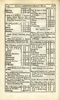 click to enlarge click to enlargeC38315.jpg page 315-316 "Lincoln's Inn Bridge / 1½Miles beyond Lincoln's Inn Bridge, on r. a T.R. to Kirkby Lonsdale." item:- JandMN : 228.1 Image © see bottom of page |
|
|
|
||
| evidence:- | old map:- Cooke 1802 placename:- Lincolns Inn Bridge |
|
| source data:- | Map, Westmoreland ie Westmorland, scale about 12 miles to 1
inch, by George Cooke, 1802, published by Sherwood, Jones and
Co, Paternoster Road, London, 1824. click to enlarge click to enlargeGRA1Wd.jpg "Lincolns Inn Bri." bridge item:- Hampshire Museums : FA2000.62.4 Image © see bottom of page |
|
|
|
||
| evidence:- | old map:- Laurie and Whittle 1806 placename:- Lincoln's Inn Bridge |
|
| source data:- | Road map, Continuation of the Roads to Glasgow and Edinburgh,
scale about 10 miles to 1 inch, by Nathaniel Coltman? 1806,
published by Robert H Laurie, 53 Fleet Street, London, 1834. click to enlarge click to enlargeLw21.jpg "Lincoln's Inn Bridge" bridge; on county boundary item:- private collection : 18.21 Image © see bottom of page |
|
|
|
||
| evidence:- | old map:- Cooper 1808 |
|
| source data:- | Map, hand coloured engraving, Westmoreland ie Westmorland, scale
about 9 miles to 1 inch, by H Cooper, 1808, published by R
Phillips, Bridge Street, Blackfriars, London, 1808. click to enlarge click to enlargeCOP4.jpg road across stream; bridge? item:- Dove Cottage : 2007.38.53 Image © see bottom of page |
|
|
|
||
| evidence:- | database:- Listed Buildings 2010 placename:- Lincolns Inn Bridge |
|
| source data:- | courtesy of English Heritage "LINCOLNS INN BRIDGE (THAT PART IN FIRBANK CP) / / A684 / FIRBANK / SOUTH LAKELAND / CUMBRIA / II / 75639 / SD6311192300" |
|
| source data:- | courtesy of English Heritage "LINCOLNS INN BRIDGE OVER THE RIVER LUNE THAT PART IN SEDBERGH CP / / A 684 / SEDBERGH / SOUTH LAKELAND / CUMBRIA / II / 484495 / SD6317692269" |
|
| source data:- | courtesy of English Heritage "Bridge over river Lune. Cl7 or C18 (repaired in 1780). Stone rubble. 2 stepped segmental arches, that to east the wider, flanking pier with triangular cutwaters, that to north a rebuilding in ashlar. Plain parapets probably rebuilt. Roadway approx. 3.5m wide." |
|
| source data:- | courtesy of English Heritage "Public road bridge over River Lune. Probably C17; altered. Mostly mixed random rubble, with parapets of coursed rubble. Two low segmental arches of unequal width, with stepped rubble voussoirs, springing from a pier near to the west bank of the river which has triangular cutwaters to both up- and downstream ends carried up as triangular buttresses. The parapets to the longer eastern span are horizontal, those to the shorter western span slope downwards. (The western half of this item is in Lambrigg CP.)" |
|
|
|
||
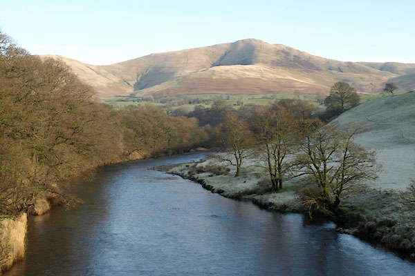 BVU53.jpg View of river. (taken 13.1.2012) |
||
|
|
||
 BJY97.jpg (taken 4.11.2005) 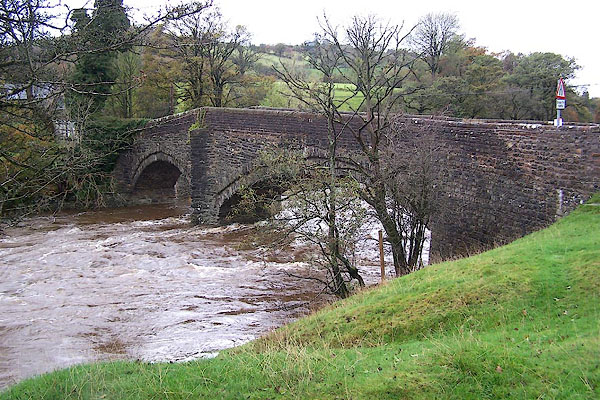 BJY98.jpg (taken 4.11.2005) |
||
|
|
||
| observation:- |
The farm at Bridge End, the west end of the bridge, is called Lincolns Inn Bridge
Farm. |
|
|
|
||
Lakes Guides menu.