 Old Cumbria Gazetteer
 |
 |
|
| Lees Scar Lighthouse, Silloth | ||
| Lees Scar Lighthouse | ||
| Tommy Legs | ||
| locality:- | Silloth | |
| civil parish:- | Silloth-on-Solway (formerly Cumberland) | |
| county:- | Cumbria | |
| locality type:- | lighthouse | |
| coordinates:- | NY09375292 | |
| 1Km square:- | NY0952 | |
| 10Km square:- | NY05 | |
|
|
||
| MN photo:- |
The light on a braced iron tower is the lighthouse; this and the East Cote Lighthouse
are leading marks for shipping approaching Silloth. |
|
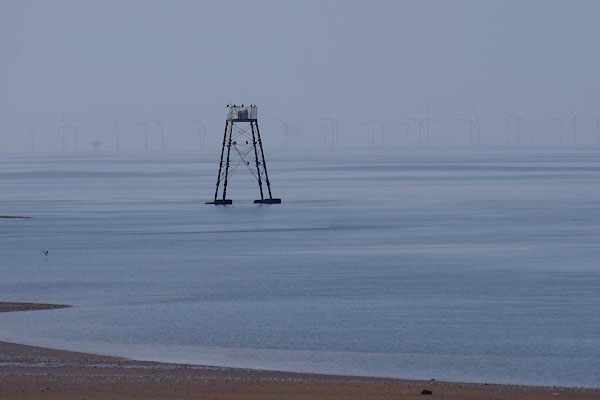 CDH33.jpg (taken 12.6.2015) 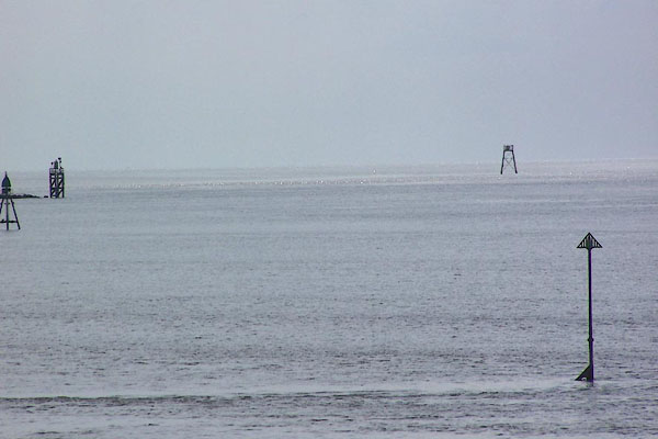 BNV80.jpg The furthest light on a braced iron tower is the lighthouse. (taken 20.6.2007) |
||
|
|
||
| evidence:- | old map:- OS County Series (Cmd 20 15) placename:- Lees Scar Lighthouse |
|
| source data:- | Maps, County Series maps of Great Britain, scales 6 and 25
inches to 1 mile, published by the Ordnance Survey, Southampton,
Hampshire, from about 1863 to 1948. |
|
|
|
||
| evidence:- | old map:- Geddes 1848 placename:- Lee Scar Light House |
|
| source data:- | Chart, uncoloured engraving, Sketch of the English Channel from
the Bar up to Port Carlisle, in the Solway Firth, scale about 2
ins to 1 mile, by W Geddes, 1848.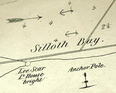 click to enlarge click to enlargeGD01P3.jpg "Lee Scar / Lt. House / bright" item:- Carlisle Library : Map 91 Image © Carlisle Library |
|
|
|
||
| evidence:- | HO chart:- Hydrographic Office 1850s onwards (edn 1973) placename:- Lees Scar |
|
| source data:- | Charts, Irish Sea, Solway Firth, etc, published by the Hydrographic Office from 1850s
onwards. "Lees Scar / 20 cc. R. / sec. 29ft. 9M. / &23ft. 2M." |
|
|
|
||
| evidence:- | old text:- Admiralty 1933 placename:- item:- tide gauge, Silloth; fog signal |
|
| source data:- |  goto source goto sourcePage 399:- "... A light is exhibited, at an elevation of 33 feet (10m1), from a white structure on piles, 45 feet (13m7) in height, situated on Lees scar, about 6 cables south-westward of Silloth pierhead (Lat. 54~ 52' N., long. 3~ 24' W.). A fog signal is sounded from the structure during tide time." "..." "... In 1932, these lights [this and East Cote Lighthouse] in line did not lead through the deepest part of the channel over the bar." "..." "Tide gauge. - A tide gauge, which indicates in large figures, the depth in the entrance to the dock, is attached to Lees Scar light-structure." |
|
|
|
||
| evidence:- | old print:- placename:- Lee Scar Light Houe |
|
| source data:- | Print, hand coloured engraving, Entrance to Silloth Bay and Dock, Cumberland, published
by Hudson Scott, litho printer, Carlisle, Cumbria, 1870.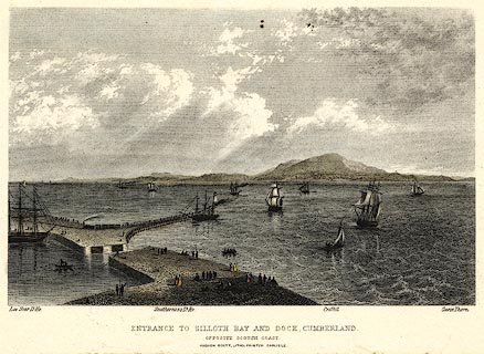 click to enlarge click to enlargePR0369.jpg There is shipping in the offing and at the dock, a train leaving the quay; some scottish coastal features are labelled - Lee Scar Light House, Southerness lighthouse, Criffel and Carse Thorn. printed at bottom:- "ENTRANCE TO SILLOTH BAY AND DOCK, CUMBERLAND. / OPPOSITE THE SCOTCH COAST / HUDSON SCOTT, LITHO PRINTER CARLISLE." item:- Dove Cottage : 2008.107.369 Image © see bottom of page |
|
|
|
||
Lakes Guides menu.