 Old Cumbria Gazetteer
 |
 |
|
| Lamplugh Hall, Lamplugh | ||
| Lamplugh Hall | ||
| locality:- | Lamplugh | |
| civil parish:- | Lamplugh (formerly Cumberland) | |
| county:- | Cumbria | |
| locality type:- | buildings | |
| coordinates:- | NY08882071 | |
| 1Km square:- | NY0820 | |
| 10Km square:- | NY02 | |
|
|
||
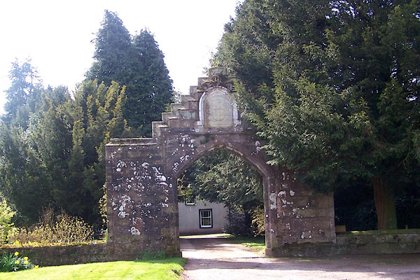 BLY35.jpg (taken 24.4.2006) 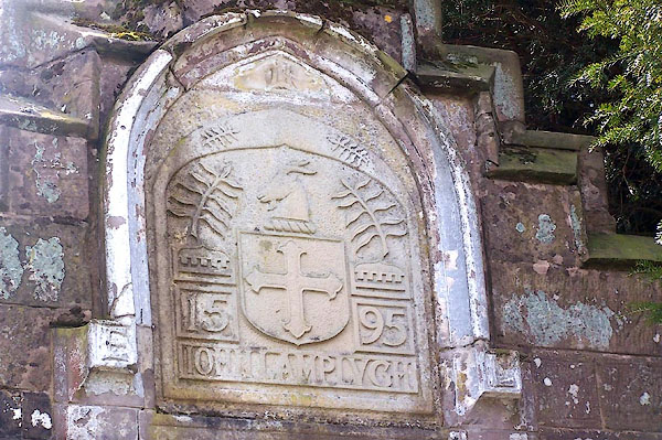 BLY36.jpg Coat of arms on the gateway:- "1595 JOHN LAMPLUGH" (taken 24.4.2006) |
||
|
|
||
| evidence:- | old map:- OS County Series (Cmd 62 15) placename:- Lamplugh Hall |
|
| source data:- | Maps, County Series maps of Great Britain, scales 6 and 25
inches to 1 mile, published by the Ordnance Survey, Southampton,
Hampshire, from about 1863 to 1948. |
|
|
|
||
| evidence:- | old map:- Ogilby 1675 (plate 96) placename:- Lampley Hall |
|
| source data:- | Road strip map, hand coloured engraving, the Road from Kendal to
Cockermouth, and the Road from Egremond to Carlisle, scale about
1 inch to 1 mile, by John Ogilby, London, 1675.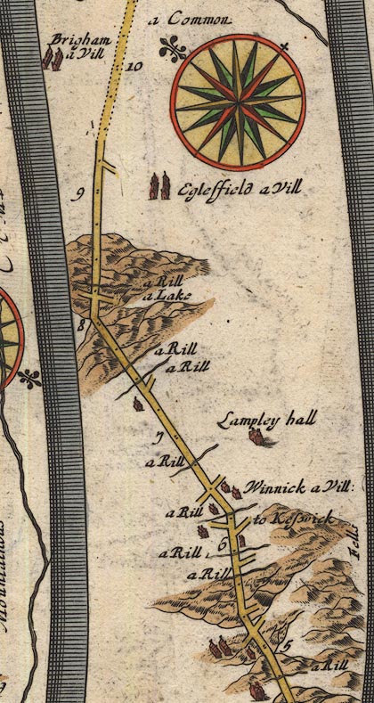 OG96Bm05.jpg In mile 6, Cumberland. "Lampley hall" house off the road to the right. item:- JandMN : 22 Image © see bottom of page |
|
|
|
||
| evidence:- | old map:- Bowen 1720 (plate 261) placename:- Lampley Hall |
|
| source data:- | Road strip map, uncoloured engraving, pl.261, the end of the
road from Kendal to Cockermouth and the road from Egremont to
Carlisle, scale about 2 miles to 1 inch, published by Emanuel
Bowen, St Katherines, London, 1720.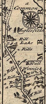 B261m05.jpg item:- Dove Cottage : Lowther.36 Image © see bottom of page |
|
|
|
||
| evidence:- | descriptive text:- Simpson 1746 placename:- Lamplugh |
|
| source data:- | Atlas, three volumes of maps and descriptive text published as
'The Agreeable Historian, or the Compleat English Traveller
...', by Samuel Simpson, 1746. goto source goto source"... Lamplugh, the Seat of Thomas Lamplugh, Esq; ..." |
|
|
|
||
| evidence:- | old map:- Bowen and Kitchin 1760 placename:- Lampley Hall |
|
| source data:- | Map, hand coloured engraving, A New Map of the Counties of
Cumberland and Westmoreland Divided into their Respective Wards,
scale about 4 miles to 1 inch, by Emanuel Bowen and Thomas
Kitchin et al, published by T Bowles, Robert Sayer, and John
Bowles, London, 1760.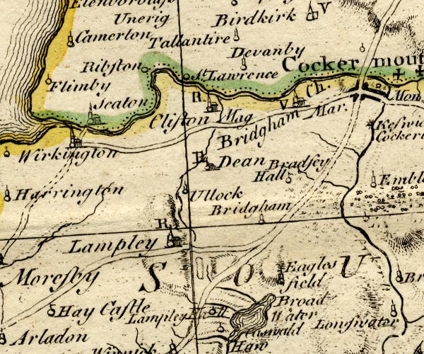 BO18NY02.jpg "Lampley Hall" circle and line item:- Armitt Library : 2008.14.10 Image © see bottom of page |
|
|
|
||
| evidence:- | old map:- Donald 1774 (Cmd) |
|
| source data:- | Map, hand coloured engraving, 3x2 sheets, The County of Cumberland, scale about 1
inch to 1 mile, by Thomas Donald, engraved and published by Joseph Hodskinson, 29
Arundel Street, Strand, London, 1774.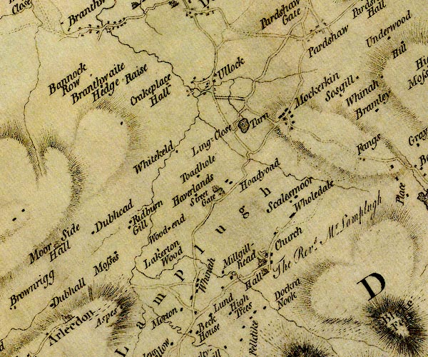 D4NY02SE.jpg "Hall / The Rev. Mr. Lamplugh" house item:- Carlisle Library : Map 2 Image © Carlisle Library |
|
|
|
||
| evidence:- | descriptive text:- Otley 1823 (5th edn 1834) |
|
| source data:- | Guide book, A Concise Description of the English Lakes, the
mountains in their vicinity, and the roads by which they may be
visited, with remarks on the mineralogy and geology of the
district, by Jonathan Otley, published by the author, Keswick,
Cumberland now Cumbria, by J Richardson, London, and by Arthur
Foster, Kirkby Lonsdale, Cumbria, 1823; published 1823-49,
latterly as the Descriptive Guide to the English Lakes. goto source "... the hall [Lamplugh] is now rebuilt in the" goto sourcePage 134:- "shape of a modern farm house, the only remains of its ancient grandeur being a gateway, with the inscription, 'John Lamplugh, 1595.' ..." |
|
|
|
||
| evidence:- | descriptive text:- Ford 1839 (3rd edn 1843) placename:- Lamplugh Hall |
|
| source data:- | Guide book, A Description of Scenery in the Lake District, by
Rev William Ford, published by Charles Thurnam, Carlisle, by W
Edwards, 12 Ave Maria Lane, Charles Tilt, Fleet Street, William
Smith, 113 Fleet Street, London, by Currie and Bowman,
Newcastle, by Bancks and Co, Manchester, by Oliver and Boyd,
Edinburgh, and by Sinclair, Dumfries, 1839. goto source Page 81:- "..." "... Lamplugh Hall, an ancient edifice situated at the foot of a lofty green hill, with an extensive view north and north-west. ... the principal gate-way leading to the hall, the residence of the family of Lamplugh, of known valour in the service of their country, but who became extinct in T. Lamplugh, who died at Copgrove, in Yorkshire, February 18th, 1783. ..." goto sourcePage 170:- "..." "Lamplugh Cross.- Near this is the old Hall of Lamplugh, situated at the foot of a green hill, commanding an extensive view to the north and north-west. The church is an antique building, near the gateway of the Hall." |
|
|
|
||
| evidence:- | database:- Listed Buildings 2010 placename:- Lamplugh Hall |
|
| source data:- | courtesy of English Heritage "LAMPLUGH HALL / / / LAMPLUGH / COPELAND / CUMBRIA / II / 76252 / NY0888920719" |
|
|
|
||
| evidence:- | database:- Listed Buildings 2010 item:- coat of arms; date stone (1595); sundial |
|
| source data:- | courtesy of English Heritage "GATEWAY AT LUMPLUGH HALL / / / LAMPLUGH / COPELAND / CUMBRIA / II / 76253 / NY0889520768" |
|
|
|
||
| notes:- |
15th century tpwer, 16th century hall, but only the gate remains |
|
| Perriam, D R &Robinson, J: 1998: Medieval Fortified Buildings of Cumbria: CWAAS::
ISBN 1 873124 23 6; illustration |
||
|
|
||
Lakes Guides menu.