 Old Cumbria Gazetteer
 |
 |
|
| Kailpot Crag, Martindale | ||
| Kailpot Crag | ||
| site name:- | Ullswater | |
| civil parish:- | Martindale (formerly Westmorland) | |
| county:- | Cumbria | |
| locality type:- | headland | |
| coordinates:- | NY43332042 (etc) | |
| 1Km square:- | NY4320 | |
| 10Km square:- | NY42 | |
|
|
||
| evidence:- | old map:- OS County Series (Wmd 12 4) placename:- Kailpot Crag |
|
| source data:- | Maps, County Series maps of Great Britain, scales 6 and 25
inches to 1 mile, published by the Ordnance Survey, Southampton,
Hampshire, from about 1863 to 1948. |
|
|
|
||
| evidence:- | old text:- Clarke 1787 placename:- Kailpot Cragg |
|
| source data:- | Guide book, A Survey of the Lakes of Cumberland, Westmorland,
and Lancashire, written and published by James Clarke, Penrith,
Cumberland, and in London etc, 1787; published 1787-93. goto source goto sourcePage 27:- "..." "Not far from this place is Kailpot-Cragg: so called, from a large, smooth, circular cavity, (much resembling a pot or boiler,) in the solid blue rock. The boat may go close to it, as at fourteen yards from the shore there is twenty-six fathom water, and the face of the rock is nearly perpendicular. Cavities of this kind are not unfrequent in rapid torrents subject to frequent floods, or in large falls of water; and these are occasioned by the rolling of stones, which are always found in them, ground as if done by an artist: but here not one of those circumstances takes place, and on that account this rock may safely be ranked among our natural curiosities." |
|
|
|
||
| evidence:- | old map:- Clarke 1787 map (Ullswater) placename:- Kail Pott Crag |
|
| source data:- | Map, A Map of the Lake Ullswater and its Environs, scale about
6.5 ins to 1 mile, by James Clarke, engraved by S J Neele, 352
Strand, published by James Clarke, Penrith, Cumberland and in
London etc, 1787.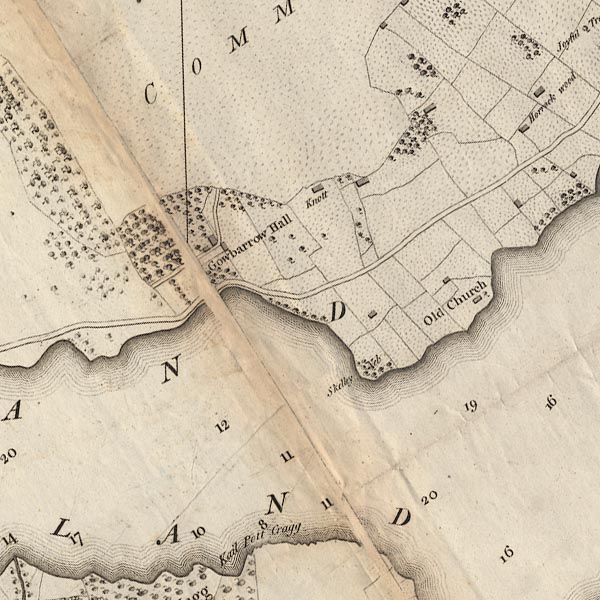 CL4NY42F.jpg "Kail Pott Crag" item:- private collection : 10.4 Image © see bottom of page |
|
|
|
||
Lakes Guides menu.