 Old Cumbria Gazetteer
 |
 |
|
| Hugh Seat, Mallerstang | ||
| Hugh Seat | ||
| Morvil Hill | ||
| civil parish:- | Mallerstang (formerly Westmorland) | |
| county:- | Cumbria | |
| locality type:- | hill | |
| coordinates:- | SD80919910 | |
| 1Km square:- | SD8099 | |
| 10Km square:- | SD89 | |
| altitude:- | 2257 feet | |
| altitude:- | 688m | |
| county:- | North Yorkshire | |
| current boundary | ||
| locality:- | Cumbria boundary | |
|
|
||
| evidence:- | old map:- Saxton 1579 placename:- Huseat Morvell Hill |
|
| source data:- | Map, hand coloured engraving, Westmorlandiae et Cumberlandiae Comitatus ie Westmorland
and Cumberland, scale about 5 miles to 1 inch, by Christopher Saxton, London, engraved
by Augustinus Ryther, 1576, published 1579-1645.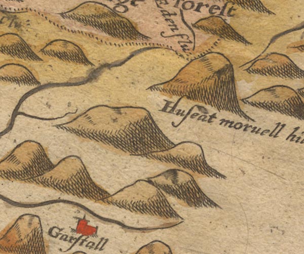 Sax9SD79.jpg "Huseat morvell hill" Large hillock. item:- private collection : 2 Image © see bottom of page |
|
|
|
||
| evidence:- | old map:- Speed 1611 (Wmd) placename:- Huseat Morvell hill |
|
| source data:- | Map, hand coloured engraving, The Countie Westmorland and
Kendale the Cheif Towne, scale about 2.5 miles to 1 inch, by
John Speed, 1610, published by George Humble, Popes Head Alley,
London, 1611-12.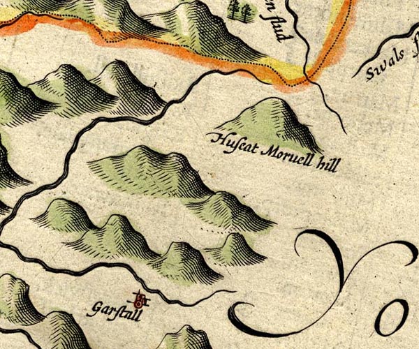 SP14SD79.jpg "Huseat Morvell hill" hillock item:- Armitt Library : 2008.14.5 Image © see bottom of page |
|
|
|
||
| evidence:- | poem:- Drayton 1612/1622 text placename:- Husseat-Morvill |
|
| source data:- | Poem, Poly Olbion, by Michael Drayton, published by published by
John Marriott, John Grismand and Thomas Dewe, and others?
London, part 1 1612, part 2 1622. goto source goto sourcepage 162:- "... ... Eden, issuing out of Husseat-Morvill Hill, And pointing to the North, as then a little Rill, There simply takes her leave of her sweet sister Swale, Borne to the selfe same Sire, but with a stronger gale, Tow'rds the Humber hyes her course, ..." |
|
|
|
||
| evidence:- | old map:- Drayton 1612/1622 placename:- Morvell Hill |
|
| source data:- | Map, hand coloured engraving, Cumberlande and Westmorlande, by
Michael Drayton, probably engraved by William Hole, scale about
4 or 5 miles to 1 inch, published by John Mariott, John
Grismand, and Thomas Dewe, London, 1622.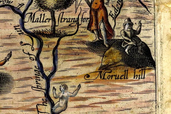 DRY526.jpg "Morvell hill" Hillock with a gentleman sitting on top. item:- JandMN : 168 Image © see bottom of page |
|
|
|
||
| evidence:- | old map:- Jansson 1646 placename:- Huseat Morvell Hill |
|
| source data:- | Map, hand coloured engraving, Cumbria and Westmoria, ie
Cumberland and Westmorland, scale about 3.5 miles to 1 inch, by
John Jansson, Amsterdam, Netherlands, 1646.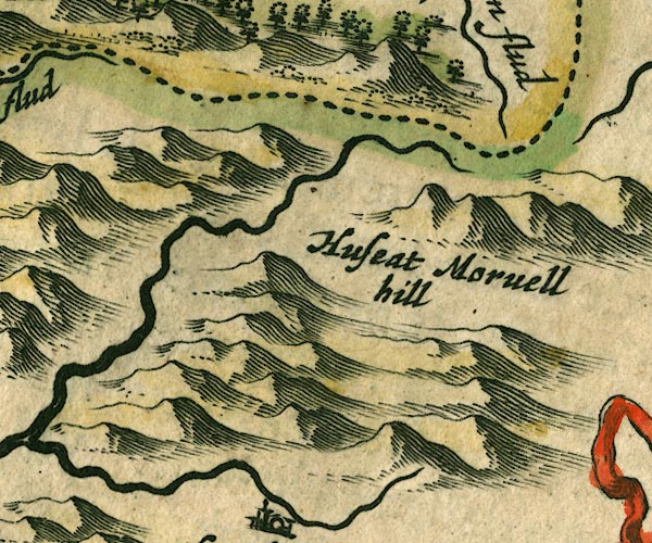 JAN3SD79.jpg "Huseat Morvell Hill" Hillock, near the county boundary. item:- JandMN : 88 Image © see bottom of page |
|
|
|
||
| evidence:- | old map:- Morden 1695 (Wmd) placename:- Hughs Head placename:- Mowill Hill |
|
| source data:- | Map, hand coloured engraving, Westmorland, scale about 2.5 miles to 1 inch, by Robert
Morden, published by Abel Swale, the Unicorn, St Paul's Churchyard, Awnsham, and John
Churchill, the Black Swan, Paternoster Row, London, 1695.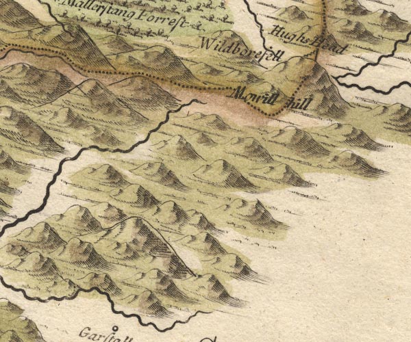 MD10SD79.jpg "Hughs Head" "Mowill hill" Hillock; the two labels copied from earlier maps have become separated. item:- JandMN : 24 Image © see bottom of page |
|
|
|
||
| evidence:- | descriptive text:- Simpson 1746 placename:- Hugh Seat Morville placename:- Hugh Morvill's Hill |
|
| source data:- | Atlas, three volumes of maps and descriptive text published as
'The Agreeable Historian, or the Compleat English Traveller
...', by Samuel Simpson, 1746. goto source Page 1020:- "..." "... the Eden, ... rises at a Place called Hugh Seat Morville, or Hugh Morvill's Hill, ..." |
|
|
|
||
| evidence:- | old map:- Simpson 1746 map (Wmd) placename:- Hutton Morvel Hill |
|
| source data:- | Map, uncoloured engraving, Westmorland, scale about 8 miles to 1
inch, printed by R Walker, Fleet Lane, London, 1746.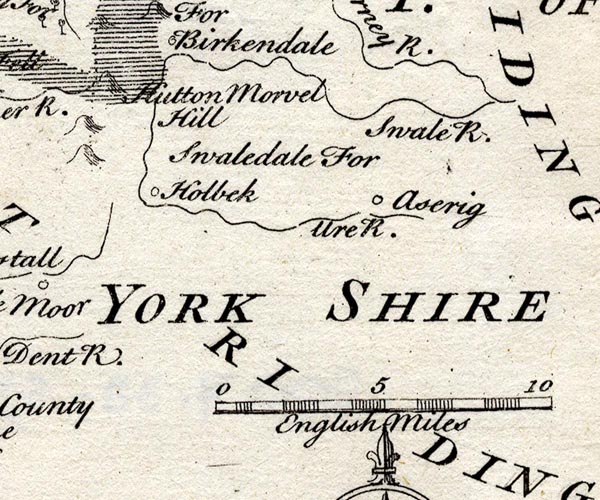 SMP2SDZ.jpg "Hutton Morvel Hill" Hillock, on the boundary with Yorkshire, West and North Ridings. item:- Dove Cottage : 2007.38.59 Image © see bottom of page |
|
|
|
||
| evidence:- | old text:- Gents Mag placename:- Hughstat placename:- Hutton Morvel item:- map |
|
| source data:- | Magazine, The Gentleman's Magazine or Monthly Intelligencer or
Historical Chronicle, published by Edward Cave under the
pseudonym Sylvanus Urban, and by other publishers, London,
monthly from 1731 to 1922. goto source Gentleman's Magazine 1754 p.230 "... the river Eden, which takes its rise from Hughstat mountain, about six miles higher up, on the skirts of Yorkshire, near the sources of the Swale and the Rother. This mountain is falsely called Hutton Morvel in most maps, and indeed, none of these desolate places have been laid down with any tolerable degree of exactness." |
|
|
|
||
| evidence:- | old map:- Bowen and Kitchin 1760 placename:- Hugh Marvil Head |
|
| source data:- | Map, hand coloured engraving, A New Map of the Counties of
Cumberland and Westmoreland Divided into their Respective Wards,
scale about 4 miles to 1 inch, by Emanuel Bowen and Thomas
Kitchin et al, published by T Bowles, Robert Sayer, and John
Bowles, London, 1760.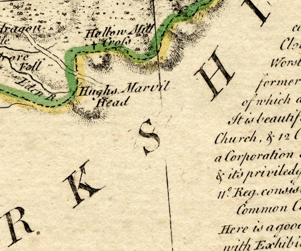 BO18NY80.jpg "Hugh Marvil Head" hill hachuring, on county boundary Westmorland Yorkshire item:- Armitt Library : 2008.14.10 Image © see bottom of page |
|
|
|
||
| evidence:- | old map:- Jefferys 1770 (Wmd) placename:- Hughs Seat |
|
| source data:- | Map, 4 sheets, The County of Westmoreland, scale 1 inch to 1
mile, surveyed 1768, and engraved and published by Thomas
Jefferys, London, 1770.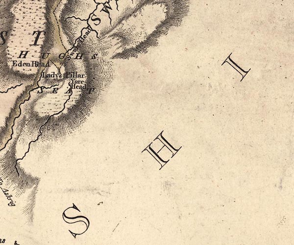 J5SD89NW.jpg "HUGHS SEAT" hill hachuring; hill or mountain, on county boundary item:- National Library of Scotland : EME.s.47 Image © National Library of Scotland |
|
|
|
||
| evidence:- | old text:- Camden 1789 (Gough Additions) placename:- Morvill Hugh Seat placename:- Hugh Morvill's Hill |
|
| source data:- | Book, Britannia, or A Chorographical Description of the Flourishing Kingdoms of England,
Scotland, and Ireland, by William Camden, 1586, translated from the 1607 Latin edition
by Richard Gough, published London, 1789. Page 156:- "..." "The river Eden rises in this county at Morvill Hugh-seat or Hugh Morvill's hill from one of that name lord of Westmorland. This is a large round hill, where Anne countess of Pembroke erected a stone pillar ..." |
|
|
|
||
| evidence:- | old map:- Ford 1839 map placename:- Hugh Seat |
|
| source data:- | Map, uncoloured engraving, Map of the Lake District of
Cumberland, Westmoreland and Lancashire, scale about 3.5 miles
to 1 inch, published by Charles Thurnam, Carlisle, and by R
Groombridge, 5 Paternoster Row, London, 3rd edn 1843.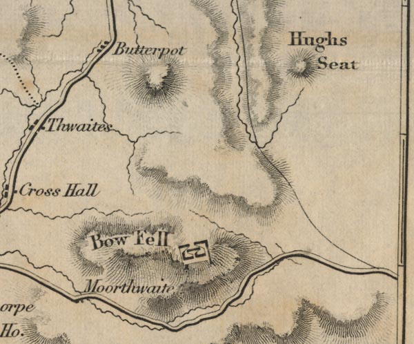 FD02SD79.jpg "Hugh Seat" Hill hachuring. item:- JandMN : 100.1 Image © see bottom of page |
|
|
|
||
| hearsay:- |
Named after Sir Hugh de Morville, one of the four knights who murdered Thomas a Becket,
1170. |
|
|
|
||
Lakes Guides menu.