 Old Cumbria Gazetteer
 |
 |
|
| Gillerthwaite, Ennerdale and Kinniside | ||
| Gillerthwaite | ||
| Gillerthwaite Farm | ||
| locality:- | Ennerdale | |
| civil parish:- | Ennerdale and Kinniside (formerly Cumberland) | |
| county:- | Cumbria | |
| locality type:- | buildings | |
| coordinates:- | NY13911410 | |
| 1Km square:- | NY1314 | |
| 10Km square:- | NY11 | |
|
|
||
| evidence:- | old map:- OS County Series (Cmd 69 13) placename:- Gillerthwaite |
|
| source data:- | Maps, County Series maps of Great Britain, scales 6 and 25
inches to 1 mile, published by the Ordnance Survey, Southampton,
Hampshire, from about 1863 to 1948. |
|
|
|
||
| evidence:- | old map:- Donald 1774 (Cmd) placename:- Gillerthwaite |
|
| source data:- | Map, hand coloured engraving, 3x2 sheets, The County of Cumberland, scale about 1
inch to 1 mile, by Thomas Donald, engraved and published by Joseph Hodskinson, 29
Arundel Street, Strand, London, 1774.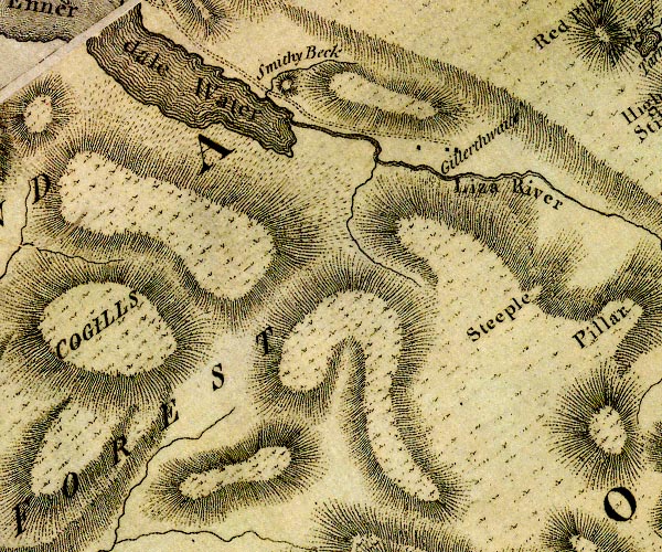 D4NY11SW.jpg "Gillerthwaite" block or blocks, labelled in lowercase; a hamlet or just a house item:- Carlisle Library : Map 2 Image © Carlisle Library |
|
|
|
||
| evidence:- | descriptive text:- West 1778 (11th edn 1821) placename:- Island of Gillerthwaite |
|
| source data:- | Guide book, A Guide to the Lakes, by Thomas West, published by
William Pennington, Kendal, Cumbria once Westmorland, and in
London, 1778 to 1821. goto source goto sourceAccount of Ennerdale, late 18th century Page 293:- "..." "... The delighted tourist will insensibly confine his view (though it is not in reality bounded by any of the lofty objects already mentioned) to the verdant island of Gillerthwaite, whose romantic situation must be seen - description cannot furnish an idea of its beauty." goto sourcePage 294:- "An essayist, in the provincial paper of this country, speaking of this place, says, 'It forms a picture such as the canvas never presented; it embraces a variety so distributed as no pencil can ever imitate. No designer in romance ever allotted such a residence to his fairy inhabitants - I had almost said, no recluse ever wooed religion in such a blessed retirement.' - 'The genius of Ovid would have transformed the most favoured of his heroes into a river, and poured his waters into the channel of the Liza, there to wander by the verdant bounds of Gillerthwaite - the sweet reward of patriotism and virtue.'" "Gillerthwaite is not, however, an island, though almost as much contrasted in the landscape as land with water. It is a patch of enclosed and apparently highly cultivated ground, on a stony desert of immeasurable extent; for the mountains on each side of it are the most barren in their aspect, and continue that appearance till their heads mix with the horizon. There are two decent farm-houses on the inclosure, and, from the serpentine tract of the valley, no other habitation of man is visible. ..." |
|
|
|
||
| evidence:- | old map:- Laurie and Whittle 1806 placename:- Guilerthwaite |
|
| source data:- | Road map, Completion of the Roads to the Lakes, scale about 10
miles to 1 inch, by Nathaniel Coltman? 1806, published by Robert
H Laurie, 53 Fleet Street, London, 1834. click to enlarge click to enlargeLw18.jpg "Guilerthwaite" village or other place item:- private collection : 18.18 Image © see bottom of page |
|
|
|
||
| evidence:- | descriptive text:- Otley 1823 (5th edn 1834) |
|
| source data:- | Guide book, A Concise Description of the English Lakes, the
mountains in their vicinity, and the roads by which they may be
visited, with remarks on the mineralogy and geology of the
district, by Jonathan Otley, published by the author, Keswick,
Cumberland now Cumbria, by J Richardson, London, and by Arthur
Foster, Kirkby Lonsdale, Cumbria, 1823; published 1823-49,
latterly as the Descriptive Guide to the English Lakes. goto source Page 26:- "... Pedestrians, anxious to explore the inmost recesses of the mountains, may follow the lake [Ennerdale Water] to its head, and after passing the sequestered farm of Gillerthwaite, continue their route four of five miles along the narrow dale, ..." |
|
|
|
||
| evidence:- | old map:- Ford 1839 map placename:- Gillerthwaite |
|
| source data:- | Map, uncoloured engraving, Map of the Lake District of
Cumberland, Westmoreland and Lancashire, scale about 3.5 miles
to 1 inch, published by Charles Thurnam, Carlisle, and by R
Groombridge, 5 Paternoster Row, London, 3rd edn 1843.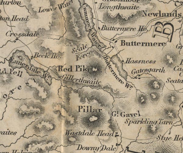 FD02NY11.jpg "Gillerthwaite" item:- JandMN : 100.1 Image © see bottom of page |
|
|
|
||
| evidence:- | old map:- Garnett 1850s-60s H placename:- Gillerthwaite |
|
| source data:- | Map of the English Lakes, in Cumberland, Westmorland and
Lancashire, scale about 3.5 miles to 1 inch, published by John
Garnett, Windermere, Westmorland, 1850s-60s.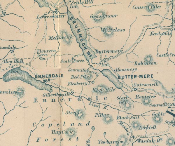 GAR2NY11.jpg "Gillerthwaite" blocks, settlement item:- JandMN : 82.1 Image © see bottom of page |
|
|
|
||
Lakes Guides menu.