 Old Cumbria Gazetteer
 |
 |
|
| Gaping Gill, North Yorkshire | ||
| Gaping Gill | ||
| Gaper Gill | ||
| Main Shaft | ||
| site name:- | Fell Beck | |
| county:- | North Yorkshire | |
| locality type:- | cave | |
| coordinates:- | SD751727 | |
| 1Km square:- | SD7572 | |
| 10Km square:- | SD77 | |
| SummaryText:- | Complicated system of caves connecting with other caves, needs a guide! The main shaft is grade IV-V. Other parts are various grades. | |
| SummaryText:- | Main Shaft descended to the ledge by J Birkbeck, 1840s; complete descent by E A Martel, 1895. Other parts explored by various groups. | |
| references:- | Brook, A & Brook, D & Davies, G M &Long, M H: 1975: Northern Caves, vol.3 Ingleborough:
Dalesman Books (Clapham, North Yorkshire):: ISBN 0 85206 312 1 |
|
|
|
||
| evidence:- | descriptive text:- Balderston c1890 placename:- Gaping Gill Hole |
|
| source data:- | Book, Ingleton, Bygone and Present, by Robert R and Margaret
Balderston, published by Simpkin, Marshall and Co, London, and
by Edmndson and Co, 24 High Street, Skipton, Yorkshire, about
1890. goto source goto sourcepage 34:- "WEATHERCOTE Cave, ... has, perhaps, no rival in England, unless it be Gaping Gill Hole, the wonders of which are practically inaccessible. ..." goto sourcepage 48:- "..." "Gaping Gill Hole." "The stream which runs from the summit of Ingleborough on the Horton side, but bends towards Clapham after a course of about two miles, throws itself headlong down an elliptic shaft in the limestone strata, straight as that of a pit, but worked out by the hand of nature through innumerable ages to a depth of three hundred and fifty-six feet. A descent has in one instance been made to a depth of one hundred and eighty feet; on reaching this point, however, it is said that a great bar of rock was found lying transversely across the hole - our plummet about this depth had invariably on the southern side to be shaken off some opposing body - and the adventurous individual, who had thus been enabled to see sights never" goto sourcepage 49:- "beheld before, felt a feeling of trepidation come over him and dared not grapple with the gloomy Avernus below, still some distance from the day. The elliptic mouth is about ten feet by twenty across. A capital little stream for trouting with the fly during a summer freshet is the one called Fell Beck, which is here engulfed in the gaping jaws of this stupendous abysmal orifice, to appear, it is supposed, close to the mouth of Clapham Cave, with which, no doubt, it has direct connection; indeed, it is affirmed that such is the case. The hole, as before stated, is three hundred and fifty-six feet deep measured to the top of the southern rock, but if the depth be taken from the elevation of the shakehole slopes around twenty-four feet more must be added, giving a total depth of three hundred and eighty feet. As the elevation of this point is about one thousand three hundred and fifty feet, the bottom of the hole must be nine hundred and seventy feet above the sea." |
|
|
|
||
| evidence:- | old map:- Balderston c1890 map placename:- Gaping Gill Hole |
|
| source data:- | Map, the hills in the Ingleton area, probably by Robert R
Balderston, engraved by Goodall and Suddick, Leeds, West
Yorkshire, about 1890.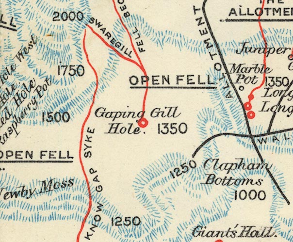 BS1SD77L.jpg "Gaping Gill Hole" item:- private collection : 27.1 Image © see bottom of page |
|
|
|
||
Lakes Guides menu.