 Old Cumbria Gazetteer
 |
 |
|
| Fell Foot, Staveley-in-Cartmel | ||
| Fell Foot | ||
| Fell Foot Park | ||
| civil parish:- | Staveley-in-Cartmel (formerly Lancashire) | |
| county:- | Cumbria | |
| locality type:- | park | |
| locality type:- | buildings | |
| coordinates:- | SD38378702 (etc) | |
| 1Km square:- | SD3887 | |
| 10Km square:- | SD38 | |
|
|
||
| evidence:- | descriptive text:- West 1778 (11th edn 1821) |
|
| source data:- | Guide book, A Guide to the Lakes, by Thomas West, published by
William Pennington, Kendal, Cumbria once Westmorland, and in
London, 1778 to 1821. goto source goto sourcePage 71, footnote:- "On the banks of Windermere-water, have been lately built many elegant villas; by ... Mr. Dixon, Fell-foot; ... These objects, as works of art, most of which are done in styles suitable to their situation, give an air of consequence to the country, ..." |
|
|
|
||
| evidence:- | old map:- Crosthwaite 1783-94 (Win/Ble) placename:- Fell Foot |
|
| source data:- | Map, uncoloured engraving, An Accurate Map of the Grand Lake of
Windermere, scale about 2 inches to 1 mile, by Peter
Crosthwaite, Keswick, Cumberland, 1783, version published 1819.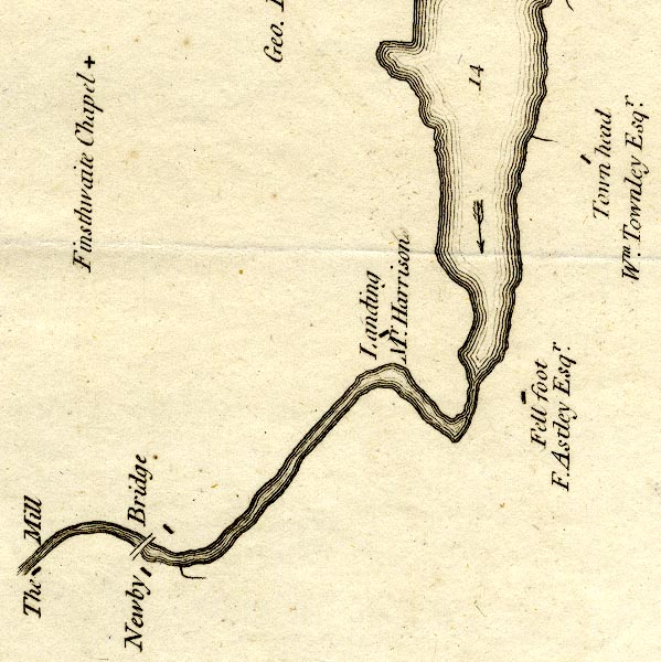 CT9SD38T.jpg "Fell foot / F. Astley Esqr." block, building/s item:- Armitt Library : 2008.14.102 Image © see bottom of page |
|
|
|
||
| evidence:- | old map:- West 1784 map placename:- Fellfoot |
|
| source data:- | Map, hand coloured engraving, A Map of the Lakes in Cumberland,
Westmorland and Lancashire, scale about 3.5 miles to 1 inch,
engraved by Paas, 53 Holborn, London, about 1784.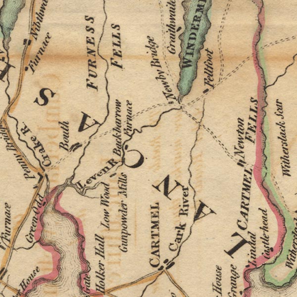 Ws02SD38.jpg item:- Armitt Library : A1221.1 Image © see bottom of page |
|
|
|
||
| evidence:- | old map:- Clarke 1787 map (Windermere S) placename:- Fell Foot |
|
| source data:- | Map, A Map of the Southern Part of the Lake Winandermere and its
Environs, scale about 6.5 ins to 1 mile, by James Clarke,
engraved by Samuel John Neele, 352 Strand, published by James
Clarke, Penrith, Cumberland and in London etc, 1787.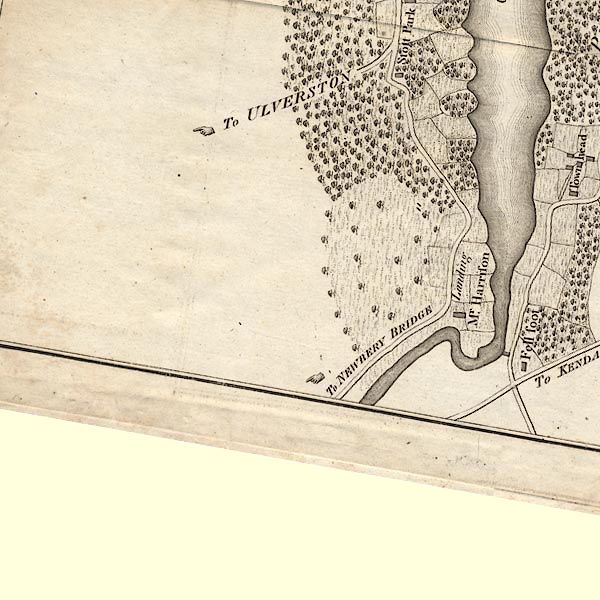 CLBSD38T.jpg "Fell Foot" item:- private collection : 10.11 Image © see bottom of page |
|
|
|
||
| evidence:- | road book:- Cary 1798 (2nd edn 1802) placename:- Fell Foot |
|
| source data:- | Road book, itineraries, Cary's New Itinerary, by John Cary, 181
Strand, London, 2nd edn 1802. goto source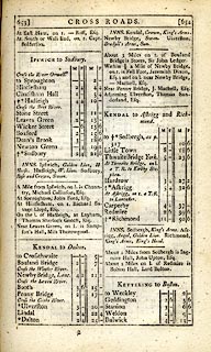 click to enlarge click to enlargeC38653.jpg page 653-654 "Within ½a Mile of Newby Bridge, on r. is Fell Foot, Jeremiah Dixon, Esq. ..." item:- JandMN : 228.2 Image © see bottom of page |
|
|
|
||
| evidence:- | old map:- Otley 1818 placename:- Fell Foot |
|
| source data:- | Map, uncoloured engraving, The District of the Lakes,
Cumberland, Westmorland, and Lancashire, scale about 4 miles to
1 inch, by Jonathan Otley, 1818, engraved by J and G Menzies,
Edinburgh, Scotland, published by Jonathan Otley, Keswick,
Cumberland, et al, 1833.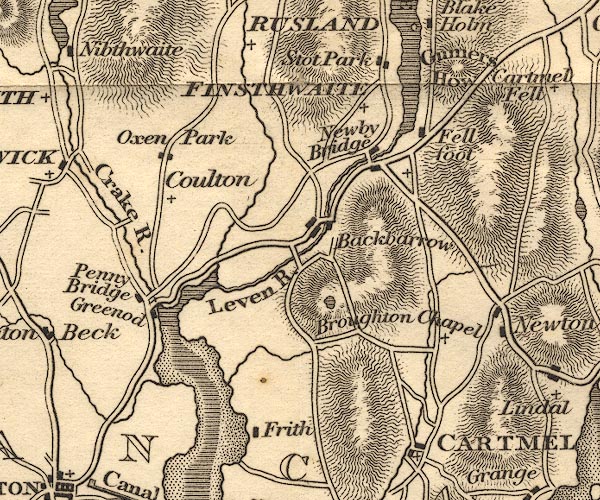 OT02SD38.jpg "Fell foot" item:- JandMN : 48.1 Image © see bottom of page |
|
|
|
||
| evidence:- | old map:- Ford 1839 map placename:- Fell Foot |
|
| source data:- | Map, uncoloured engraving, Map of the Lake District of
Cumberland, Westmoreland and Lancashire, scale about 3.5 miles
to 1 inch, published by Charles Thurnam, Carlisle, and by R
Groombridge, 5 Paternoster Row, London, 3rd edn 1843.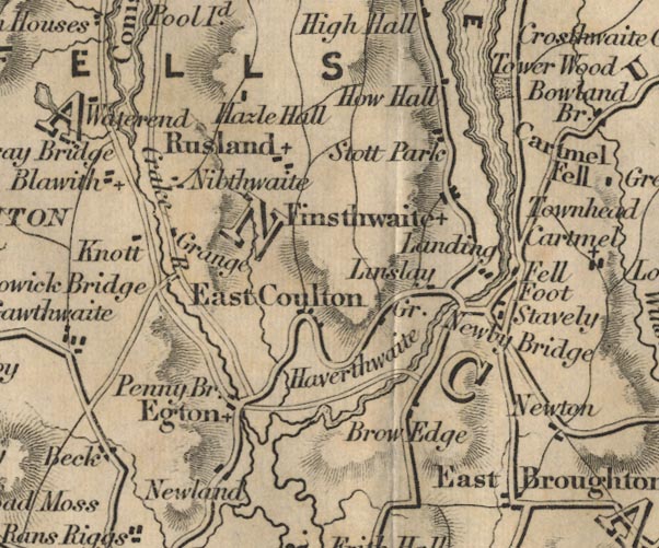 FD02SD38.jpg "Fell Foot" item:- JandMN : 100.1 Image © see bottom of page |
|
|
|
||
| evidence:- | old map:- Garnett 1850s-60s H placename:- Fellfoot |
|
| source data:- | Map of the English Lakes, in Cumberland, Westmorland and
Lancashire, scale about 3.5 miles to 1 inch, published by John
Garnett, Windermere, Westmorland, 1850s-60s.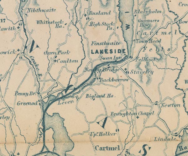 GAR2SD38.jpg "Fellfoot" blocks, settlement item:- JandMN : 82.1 Image © see bottom of page |
|
|
|
||
| evidence:- | old map:- Prior 1874 map 1 placename:- Fell Foot |
|
| source data:- | Map, uncoloured engraving or lithograph? Winander Mere, scale
about 2.5 miles to 1 inch, published by John Garnett,
Windermere, Westmorland, 1874. click to enlarge click to enlargePI03M1.jpg "Fell Foot" block/s; building/s item:- private collection : 133.1 Image © see bottom of page |
|
|
|
||
| evidence:- | database:- Listed Buildings 2010 |
|
| source data:- | courtesy of English Heritage "MANAGER'S HOUSE, FELL FOOT PARK / / A592 / STAVELEY IN CARTMEL / SOUTH LAKELAND / CUMBRIA / II / 421914 / SD3816487118" |
|
|
|
||
| evidence:- | old print:- placename:- Fell Foot |
|
| source data:- | Print, coloured lithograph, Fell Foot, Windermere, Lancashire, engraved by J McGahey,
from a photograph by Bowness, printed by J Richardson, Barrow-in-Furness, 1870?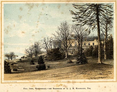 click to enlarge click to enlargePR0060.jpg printed at bottom left, right, centre:- "On Stone by J. McGahey / from a Photograph by Bowness / &Printed by J Richardson, Barrow in Furness / FELL FOOT, WINDERMERE,- THE RESIDENCE OF G. J. M. RIDEHALGH, ESQ." item:- Dove Cottage : 2008.107.60 Image © see bottom of page |
|
|
|
||
| evidence:- | old drawing:- item:- boat |
|
| source data:- | Drawing, Fell Foot, Windermere, Seat of Townley Esq, Staveley-in-Cartmel, Lancashire,
by William Havell, 1817.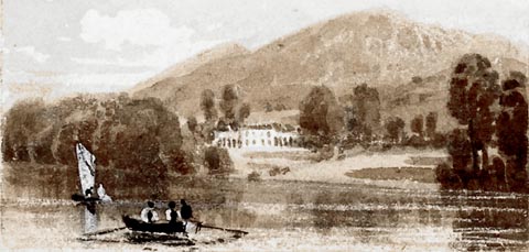 click to enlarge click to enlargePR1412.jpg Windermere lake in foreground with rowing boat and sailing boat. In the centre of the composition on the far distant shore stands a large residence surrounded by trees with hills behind. One of a set of eight 'Drawings for a Pocket Book' intended to be engraved executed on the spot by the artist. Eight drawings pasted to one piece of paper all executed in pencil, brown wash and white gouache. at bottom right:- "October 1817" item:- Tullie House Museum : 2009.89.60 Image © Tullie House Museum |
|
|
|
||
Lakes Guides menu.