 Old Cumbria Gazetteer
 |
 |
|
|
| Egremont and Sellafield branch railway | |||
| civil parish:- | Egremont (formerly Cumberland) | ||
| civil parish:- | St John Beckermet (formerly Cumberland) | ||
| civil parish:- | Lowside Quarter (formerly Cumberland) | ||
| civil parish:- | St Bridget Beckermet (formerly Cumberland) | ||
| county:- | Cumbria | ||
| locality type:- | railway | ||
| SummaryText:- | from Egremont at the end of the Whitehave, Cleator and Egremont Railway, through Beckermet, to Sellafield, on the Whitehaven and Furness Junction Railway, Cumberland. | ||
| references:- | 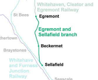 RWY029.jpg |
||
|
|
|||
| evidence:- | old map:- Garnett 1850s-60s H |
||
| source data:- | Map of the English Lakes, in Cumberland, Westmorland and
Lancashire, scale about 3.5 miles to 1 inch, published by John
Garnett, Windermere, Westmorland, 1850s-60s.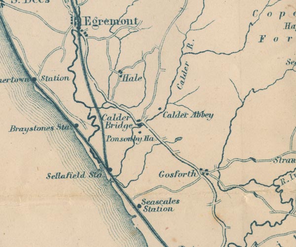 GAR2NY00.jpg triple line, light bold light, railway item:- JandMN : 82.1 Image © see bottom of page |
||
|
|
|||
| person:- | railway company : Whitehaven, Cleator and Egremont Railway |
||
| date:- | 1866 to 1877 |
||
|
|
|||
| goes through:- |  Egremont Station, Egremont Beckermet Mine Branch Junction, St John Beckermet railway bridge, St John Beckermet Beckermet Station, Beckermet railway viaduct, Beckermet railway bridge, Beckermet (2) railway bridge, Beckermet Sellafield Junction, St Bridget Beckermet Egremont Station, Egremont Beckermet Mine Branch Junction, St John Beckermet railway bridge, St John Beckermet Beckermet Station, Beckermet railway viaduct, Beckermet railway bridge, Beckermet (2) railway bridge, Beckermet Sellafield Junction, St Bridget Beckermet28.6.1866: authorized - 1869: opened - |
||
|
|
|||
Lakes Guides menu.