 Old Cumbria Gazetteer
 |
 |
|
| Easegill Kirk, Casterton | ||
| Easegill Kirk | ||
| site name:- | Ease Gill (2) | |
| civil parish:- | Casterton (formerly Westmorland) | |
| county:- | Cumbria | |
| locality type:- | ravine | |
| locality type:- | valley | |
| coordinates:- | SD661800 | |
| 1Km square:- | SD6680 | |
| 10Km square:- | SD68 | |
| county:- | Lancashire | |
| current boundary | ||
| locality:- | Cumbria boundary | |
|
|
||
| evidence:- | old map:- OS County Series placename:- Ease Gill Church |
|
| source data:- | Maps, County Series maps of Great Britain, scales 6 and 25
inches to 1 mile, published by the Ordnance Survey, Southampton,
Hampshire, from about 1863 to 1948. "Ease Gill Church" |
|
|
|
||
| evidence:- | descriptive text:- Otley 1823 (8th edn 1849) placename:- Easgill placename:- Easgill Kirk |
|
| source data:- | Print, engraving, Scene in Easgill, Casterton, drawn by Mr
Binns, Halifax, engraved by Mr Jewitt, Headington, Oxfordshire,
published by Jonathan Otley, Keswick, Cumberland et al, 1849. goto source goto sourcePage 191:- "..." "Let us begin with Easgill, ..." 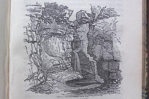 click to enlarge click to enlargeO80E47.jpg "SCENE IN EASGILL." item:- Armitt Library : A1180.36 Image © see bottom of page "EASGILL is a tremendous rocky ravine betwixt Leck and Casterton Fells, abounding in natural curiosities. It is three miles from Kirkby Lonsdale, and may be approached by two routes:- one, direct, over Low Casterton Fell End; the other by Cowen Bridge, Leck, and" goto sourcePage 192:- "Leck Fell: the latter, however, is the best carriage route. Easgill is dry in the summer months; unless during a thunder shower, or continued rains. In the winter season, when the snow is melting, or the clouds pour down their waters, it is a mountain torrent of the most rapid and tumultuous nature, forming a succession of whirlpools, waterfalls, and eddies, unsurpassed in Britain." "..." "... The path from the cave [Witches' Holes] to Easgill Kirk is dangerous and difficult. Pass the 'Dangerous Gate,' on the left side of the gill, over a narrow ledge in the face of the precipice, and you are at once in" "EASGILL KIRK.- You are now standing upon the primitive pavement of a river's bed, forming an area of at least 200 yards in circumference, inclosed on all sides but one by gigantic perpendicular cliffs, rising from one to two hundred feet, and ornamented at the top, and in various parts of the sides, by trees, shrubs, and creeping plants. In time of floods, there is a beautiful fall of water in the north-east corner, of about 30 feet; and another in the 'Choir,' a little to the right. The Choir is entered by a fine arch, 8 feet high, and 14 feet broad. The interior is a small lofty apartment; and just over the entrance, on the opposite side, is a grotesque petrifaction suspended from the roof, called 'The Priest of Easgill.'" |
|
|
|
||
| evidence:- | descriptive text:- Balderston c1890 placename:- Easegill Kirk placename:- Choir, The placename:- Priest of Easegill item:- stalactite |
|
| source data:- | Book, Ingleton, Bygone and Present, by Robert R and Margaret
Balderston, published by Simpkin, Marshall and Co, London, and
by Edmndson and Co, 24 High Street, Skipton, Yorkshire, about
1890. goto source page 66:- "..." "Scaling the ridge of Greygareth, or if proceeding directly from Ingleton, passing through Ireby, there are found on the other side of the mountain more wonders ... it is to Ease Gill Kirk and Foss, and last, though by no means least, the Witches' Cave or Holes, we must direct our steps. ... before making any remarks, will give an interesting extract from the Lonsdale Magazine for the year 1820, ... wherein the writer says:- '..." goto sourcepage 68:- "'[Easegill] Kirk is further up the gill hard by; the way is difficult, leading by the Dangerous Gate, along a narrow ledge of the precipice. The Kirk is a place formed by the river's bed, and about two hundred yards in girth, hemmed in by gigantic crags on every side one hundred feet above the space below' - much too high, on the north fifty-five, on the south fifty-one feet. 'The stream is usually dry, but in a time of spate a fall of about thirty feet in height' - eighteen feet only - 'of a fine contour, dashes down the north eastern corner and a second to the right, in a portion called the Choir, which can be entered by an arch eight feet high and fourteen broad' - four feet too much. 'A grotesque stalactitic body within, above the entrance, hanging from above, is called the Priest of Easegill.'" |
|
|
|
||
| evidence:- | old map:- Balderston c1890 map placename:- Ease Gill Kirk |
|
| source data:- | Map, the hills in the Ingleton area, probably by Robert R
Balderston, engraved by Goodall and Suddick, Leeds, West
Yorkshire, about 1890.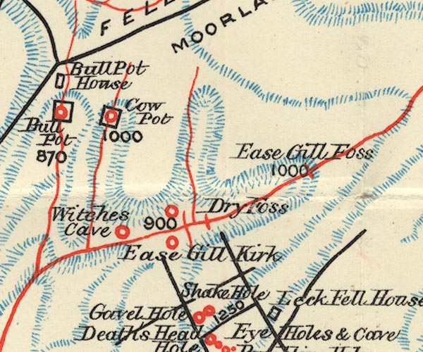 BS1SD68Q.jpg "Ease Gill Kirk" item:- private collection : 27.1 Image © see bottom of page |
|
|
|
||
Lakes Guides menu.