 Old Cumbria Gazetteer
 |
 |
|
| Easegill Foss, Casterton | ||
| Easegill Foss | ||
| site name:- | Ease Gill (2) | |
| civil parish:- | Casterton (formerly Westmorland) | |
| county:- | Cumbria | |
| locality type:- | waterfall | |
| coordinates:- | SD67488053 | |
| 1Km square:- | SD6780 | |
| 10Km square:- | SD68 | |
| current boundary | ||
| locality:- | Cumbria boundary | |
| references:- | Balderston c1890 map |
|
|
|
||
| evidence:- | perhaps descriptive text:- Otley 1823 (8th edn 1849) placename:- Force, The |
|
| source data:- | Guide book, A Concise Description of the English Lakes, the
mountains in their vicinity, and the roads by which they may be
visited, with remarks on the mineralogy and geology of the
district, by Jonathan Otley, published by the author, Keswick,
Cumberland now Cumbria, by J Richardson, London, and by Arthur
Foster, Kirkby Lonsdale, Cumbria, 1823; published 1823-49,
latterly as the Descriptive Guide to the English Lakes. goto source goto sourcePage 193:- "Climb the hill on the south-west side of the Kirk, and take a narrow path which winds along the summit, from which there is a fine view into the interior. Descend again into the bed of the river above, and you have, on either side, particularly on the south, a range of high cliffs, having the appearance of a large fort in ruins. About a quarter of a mile up the ravine, you come in sight of" "THE FORCE.- It is of smaller dimensions than the Kirk, and of a different character. On standing at the entrance, it reminded us of nothing so strongly as the stage of a theatre prepared for a Brigand scene. Thin pieces of rock project from the sides, nearly into the middle of the area, and a large oblong loophole, of singular construction, admits the water at the furthest or eastern extremity. The rocks rise to a considerable height on each side, and are, as usual, fringed with trees, which almost overshadow it." |
|
|
|
||
| evidence:- | descriptive text:- Balderston c1890 placename:- Easegill Foss placename:- Easegill Force |
|
| source data:- | Book, Ingleton, Bygone and Present, by Robert R and Margaret
Balderston, published by Simpkin, Marshall and Co, London, and
by Edmndson and Co, 24 High Street, Skipton, Yorkshire, about
1890. goto source page 68:- "..." "... Above the latter [Easegill Kirk], rugged, but not continuous rocks, rise to a great height on either hand of the stream, and about a hundred yards beyond this point is a fall - usually dry, however - fifteen feet high. Half a mile or more further up the river, between a line of high cliffs, which flank the river, is the Force. Narrow plates, or flanges, of rock projecting from either side of the upper portion of the rift, give a peculiar effect to the scene, and have been compared to 'the stage of a theatre prepared for a Brigand scene,' and through a 'loop-holed' orifice the waters of the cascade shoot, descending from the east, the vertical height of this broken fall being twenty-seven feet. An author, not quoted, gives the height of the Easegill Kirk rocks as two hundred feet, which is an outlandish error; in our quotation from a still older writer, we have inserted the needful corrections. In the same rocks there are three small caves admirably adapted for shelter or camp fires during a pic-nic, and for boiling a kettle in true witch's style." |
|
|
|
||
| evidence:- | old map:- Balderston c1890 map placename:- Ease Gill Foss |
|
| source data:- | Map, the hills in the Ingleton area, probably by Robert R
Balderston, engraved by Goodall and Suddick, Leeds, West
Yorkshire, about 1890.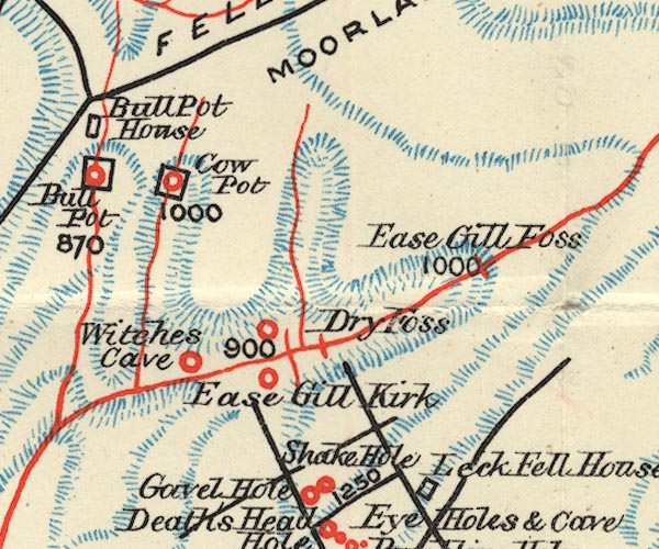 BS1SD68Q.jpg "Ease Gill Foss" item:- private collection : 27.1 Image © see bottom of page |
|
|
|
||
Lakes Guides menu.