 Old Cumbria Gazetteer
 |
 |
|
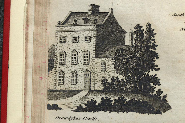
| Drawdykes Castle, Stanwix Rural | ||
| Drawdykes Castle | ||
| locality:- | Drawdykes | |
| locality:- | Hadrian's Wall | |
| civil parish:- | Stanwix Rural (formerly Cumberland) | |
| county:- | Cumbria | |
| locality type:- | castle (?) | |
| locality type:- | pele tower | |
| coordinates:- | NY41925858 | |
| 1Km square:- | NY4158 | |
| 10Km square:- | NY45 | |
|
|
||
| evidence:- | old map:- OS County Series (Cmd 16 16) placename:- Drawdykes Castle |
|
| source data:- | Maps, County Series maps of Great Britain, scales 6 and 25
inches to 1 mile, published by the Ordnance Survey, Southampton,
Hampshire, from about 1863 to 1948. "Drawdykes Castle" "Castle (Site of)" |
|
|
|
||
| evidence:- | old map:- Bowen and Kitchin 1760 placename:- Drawdikes |
|
| source data:- | Map, hand coloured engraving, A New Map of the Counties of
Cumberland and Westmoreland Divided into their Respective Wards,
scale about 4 miles to 1 inch, by Emanuel Bowen and Thomas
Kitchin et al, published by T Bowles, Robert Sayer, and John
Bowles, London, 1760.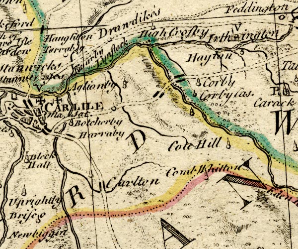 BO18NY45.jpg "Drawdikes" circle item:- Armitt Library : 2008.14.10 Image © see bottom of page |
|
|
|
||
| evidence:- | old map:- Donald 1774 (Cmd) placename:- Draw Dikes |
|
| source data:- | Map, hand coloured engraving, 3x2 sheets, The County of Cumberland, scale about 1
inch to 1 mile, by Thomas Donald, engraved and published by Joseph Hodskinson, 29
Arundel Street, Strand, London, 1774. D4NY45NW.jpg "Draw Dikes" block or blocks, labelled in lowercase; a hamlet or just a house item:- Carlisle Library : Map 2 Image © Carlisle Library |
|
|
|
||
| evidence:- | old text:- Camden 1789 (Gough Additions) placename:- Drawdikes item:- inscription, roman; roman inscription; altar, roman; roman altar |
|
| source data:- | Book, Britannia, or A Chorographical Description of the Flourishing Kingdoms of England,
Scotland, and Ireland, by William Camden, 1586, translated from the 1607 Latin edition
by Richard Gough, published London, 1789. goto source goto sourcePage 195:- "..." "At Drawdikes, a seat of the Aglionbys, near the former inscription is another," "COH IIII PR. POS. [ ]I VK. VI TAKIS" "Bishop Gibson gives the following also here:" "I. O. M. ALA AVG. O.. B. VRI APPIA IVL. PVB PS. T. TB. CETBERI..." "which Dr. Gale corrects" "Jovi Optimo Maximo Ala Augusta ob virtutem appellata Julius Publius &Tiberius Claud. Tiberii filius." "as in Horsley's Cumb. No LVI. But Mr. Horsley could hear of no such altar, and inclined to suspect it to have been mistaken for one of those yet remaining at Drumburgh. He gives a 4th (XL.) which he thinks belongs here, and two more XLI. XLII. The inscription in Camden is also now at Drawdikes, but the horseman armed with a lance which he mentions is gone, and never seems to have been part of this." |
|
|
|
||
| evidence:- | road book:- Cary 1798 (2nd edn 1802) placename:- Drawdikes |
|
| source data:- | Road book, itineraries, Cary's New Itinerary, by John Cary, 181
Strand, London, 2nd edn 1802. goto source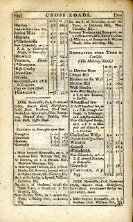 click to enlarge click to enlargeC38699.jpg page 699-700 "Drawdikes" item:- JandMN : 228.2 Image © see bottom of page |
|
|
|
||
| evidence:- | database:- Listed Buildings 2010 placename:- Drawdykes Castle |
|
| source data:- | courtesy of English Heritage "DRAWDYKES CASTLE / / / STANWIX RURAL / CARLISLE / CUMBRIA / II[star] / 77642 / NY4190758549" |
|
| source data:- | courtesy of English Heritage "Farmhouse, formerly tower home. Probably C14, converted to house 1676 by William Thackery and John Aglionby. Mixed red and yellow sandtone walls, mostly from the Roman Wall nearby, gabled slate roof. 3 storeys, 3 bays. Basically the original tower with Classical Revival faade and rear windows Chamfered plinth course. Entrance has moulded surround with triangular pediment, C19 6-panel door. Moulded surrounds to sash windows with glazing bars, having alternating segmented and triangular pediments, but no pediments to second floor windows. Calciferous sandstone ashlar quoins, moulded cornice and parapet with central coat of arms over which is carved head possibly of John Aglionby. West wall has roof moulding of adjoining building which was demolished c1764 to build the attached farmhouse (now very much altered). Rear wall has built-in Roman altar; and re-used lintel stone inscribed to Alan de Penitona, who was mayor of Carlisle in 1287, is inside. Interior now used for storage and impossible to inspect. One of the earliest Classical Revival facades in the area. See, Curwen, Castles & Towers of Cumberland &Westmorland, 1913, p. 368." |
|
|
|
||
 BOW97.jpg From Hutchinson 1794 map 2. |
||
|
|
||
| hearsay:- |
15th century pele tower, incorporated in a 17th century house. |
|
|
|
||
| notes:- |
site of fortified manor house, now a 17th and18th century house |
|
| Perriam, D R &Robinson, J: 1998: Medieval Fortified Buildings of Cumbria: CWAAS::
ISBN 1 873124 23 6; plan and illustration |
||
|
|
||
Lakes Guides menu.