 Old Cumbria Gazetteer
 |
 |
|
| Dockray Hall, Kendal | ||
| gone | ||
| Dockray Hall | ||
| Dockwray Hall | ||
| locality:- | Kendal | |
| civil parish:- | Kendal (formerly Westmorland) | |
| county:- | Cumbria | |
| locality type:- | building/s (gone?) | |
| coordinates:- | SD51359345 (estimate) | |
| 1Km square:- | SD5193 | |
| 10Km square:- | SD59 | |
|
|
||
| evidence:- | old map:- OS County Series (Wmd 38 4) placename:- Dockray Hall placename:- Dockray Hall Barn |
|
| source data:- | Maps, County Series maps of Great Britain, scales 6 and 25
inches to 1 mile, published by the Ordnance Survey, Southampton,
Hampshire, from about 1863 to 1948. "Dockray Hall Barn / Site of Dockray Hall" |
|
|
|
||
| evidence:- | old map:- Speed 1611 placename:- Dockrey Hall |
|
| source data:- | Map, hand coloured engraving, The Countie Westmorland and
Kendale the Cheif Towne, scale about 2.5 miles to 1 inch, by
John Speed, 1610, published by George Humble, Popes Head Alley,
London, 1611-12.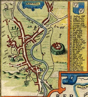 click to enlarge click to enlargeSP14Mk.jpg "A Dockrey Hall" walled buildings and tower item:- Armitt Library : 2008.14.5 Image © see bottom of page |
|
|
|
||
| evidence:- | old map:- Ogilby 1675 (plate 38) placename:- Dockrey Hall |
|
| source data:- | Road strip map, hand coloured engraving, continuation of the
Road from London to Carlisle, scale about 1 inch to 1 mile, by
John Ogilby, London, 1675.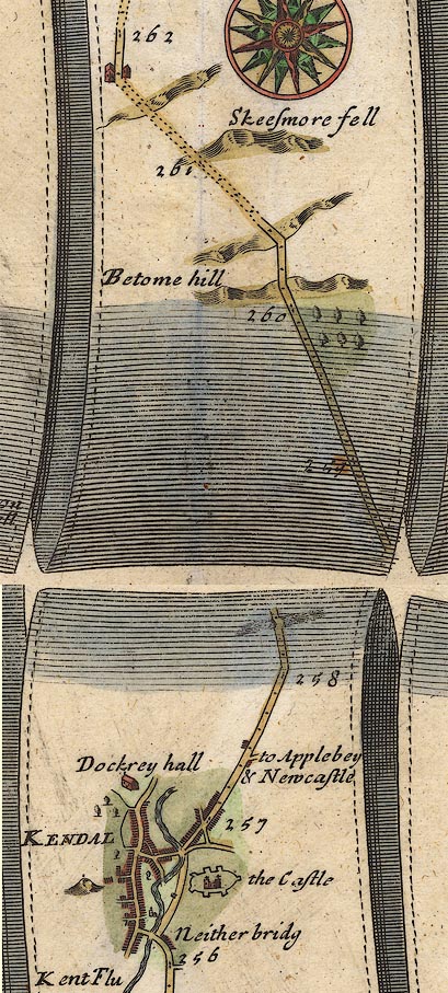 OG38m257.jpg In mile 257, Westmoreland. "Dockrey hall" drawing of a house, left of a road out of Kendal. item:- JandMN : 21 Image © see bottom of page |
|
|
|
||
| evidence:- | old map:- Bowen 1720 (plate 93) placename:- Dockrey Hall |
|
| source data:- | Strip maps, uncoloured engravings, road maps, The Road from
London to Carlisle, scale about 2 miles to 1 inch, with sections
in Lancashire and Westmorland, published by Emanuel Bowen, St
Katherines, London, 1720.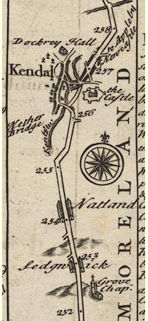 B093m252.jpg item:- Dove Cottage : 2007.38.100 Image © see bottom of page |
|
|
|
||
| evidence:- | old map:- Bowen and Kitchin 1760 placename:- Dockrey Hall |
|
| source data:- | Map, hand coloured engraving, A New Map of the Counties of
Cumberland and Westmoreland Divided into their Respective Wards,
scale about 4 miles to 1 inch, by Emanuel Bowen and Thomas
Kitchin et al, published by T Bowles, Robert Sayer, and John
Bowles, London, 1760.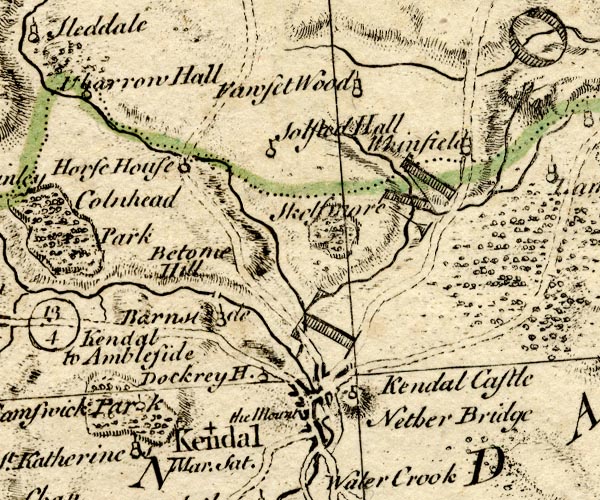 BO18SD49.jpg "Dockrey H." circle and line item:- Armitt Library : 2008.14.10 Image © see bottom of page |
|
|
|
||
| evidence:- | old map:- Jefferys 1770 placename:- Docre Hall |
|
| source data:- | Map, 4 sheets, The County of Westmoreland, scale 1 inch to 1
mile, surveyed 1768, and engraved and published by Thomas
Jefferys, London, 1770.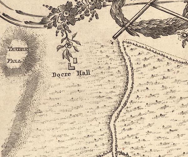 J55193H.jpg "Docre Hall" building/s item:- National Library of Scotland : EME.s.47 Image © National Library of Scotland |
|
|
|
||
| evidence:- | old map:- Jefferys 1770 (Wmd) placename:- Doker Hall |
|
| source data:- | Map, 4 sheets, The County of Westmoreland, scale 1 inch to 1
mile, surveyed 1768, and engraved and published by Thomas
Jefferys, London, 1770. J5SD59SW.jpg "Doker Hall" house item:- National Library of Scotland : EME.s.47 Image © National Library of Scotland |
|
|
|
||
| evidence:- | old map:- Cary 1789 (edn 1805) placename:- Doker Hall |
|
| source data:- | Map, uncoloured engraving, Westmoreland, scale about 2.5 miles
to 1 inch, by John Cary, London, 1789; edition 1805. CY24SD59.jpg "Doker Hall" house symbol; large house item:- JandMN : 129 Image © see bottom of page |
|
|
|
||
| notes:- |
site of tower and hall |
|
| Perriam, D R &Robinson, J: 1998: Medieval Fortified Buildings of Cumbria: CWAAS::
ISBN 1 873124 23 6 |
||
|
|
||
 Lakes Guides menu.