 Old Cumbria Gazetteer
 |
 |
|
| Clifton | ||
| civil parish:- | Clifton (formerly Westmorland) | |
| county:- | Cumbria | |
| locality type:- | buildings | |
| coordinates:- | NY53412663 (etc) | |
| 1Km square:- | NY5326 | |
| 10Km square:- | NY52 | |
|
|
||
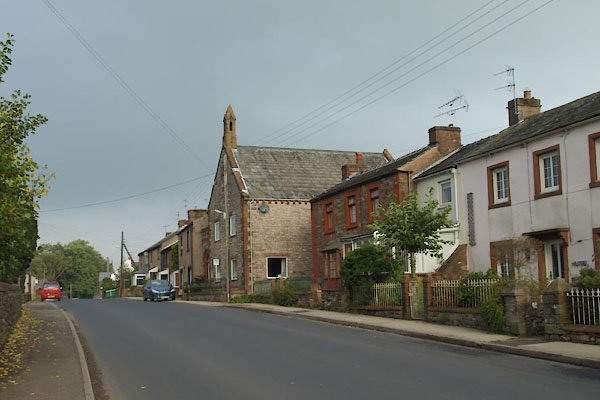 BTP66.jpg (taken 8.10.2010) |
||
|
|
||
| evidence:- | old map:- OS County Series (Wmd 8 1) placename:- Clifton |
|
| source data:- | Maps, County Series maps of Great Britain, scales 6 and 25
inches to 1 mile, published by the Ordnance Survey, Southampton,
Hampshire, from about 1863 to 1948. |
|
|
|
||
| evidence:- | old map:- Saxton 1579 placename:- Clifton |
|
| source data:- | Map, hand coloured engraving, Westmorlandiae et Cumberlandiae Comitatus ie Westmorland
and Cumberland, scale about 5 miles to 1 inch, by Christopher Saxton, London, engraved
by Augustinus Ryther, 1576, published 1579-1645.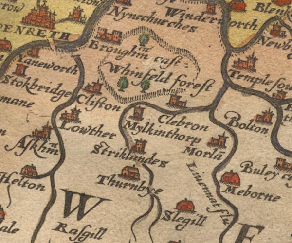 Sax9NY52.jpg Church, symbol for a parish or village, with a parish church. "Clifton" item:- private collection : 2 Image © see bottom of page |
|
|
|
||
| evidence:- | old map:- Speed 1611 (Wmd) placename:- Clifton |
|
| source data:- | Map, hand coloured engraving, The Countie Westmorland and
Kendale the Cheif Towne, scale about 2.5 miles to 1 inch, by
John Speed, 1610, published by George Humble, Popes Head Alley,
London, 1611-12.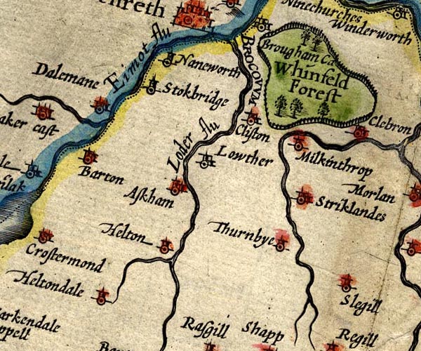 SP14NY52.jpg "Clifton" circle, building and tower item:- Armitt Library : 2008.14.5 Image © see bottom of page |
|
|
|
||
| evidence:- | old map:- Jansson 1646 placename:- Cliston |
|
| source data:- | Map, hand coloured engraving, Cumbria and Westmoria, ie
Cumberland and Westmorland, scale about 3.5 miles to 1 inch, by
John Jansson, Amsterdam, Netherlands, 1646.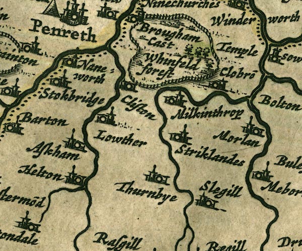 JAN3NY52.jpg "Cliston" Buildings and tower. item:- JandMN : 88 Image © see bottom of page |
|
|
|
||
| evidence:- | hearth tax returns:- Hearth Tax 1670 placename:- Cliffton Towne |
|
| source data:- | Records, hearth tax returns, exchequer duplicates, Westmorland,
1670. "Cliffton Towne" |
|
|
|
||
| evidence:- | old map:- Ogilby 1675 (plate 38) |
|
| source data:- | Road strip map, hand coloured engraving, continuation of the
Road from London to Carlisle, scale about 1 inch to 1 mile, by
John Ogilby, London, 1675.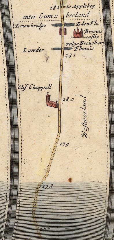 OG38m277.jpg In mile 279, Westmorland, at:- "Clif Chappell" the church drawn close to the road on the left. item:- JandMN : 21 Image © see bottom of page |
|
|
|
||
| evidence:- | old map:- Seller 1694 (Wmd) placename:- Clifton |
|
| source data:- | Map, hand coloured engraving, Westmorland, scale about 8 miles
to 1 inch, by John Seller, 1694. click to enlarge click to enlargeSEL7.jpg "Clifton" circle, italic lowercase text; settlement or house item:- Dove Cottage : 2007.38.87 Image © see bottom of page |
|
|
|
||
| evidence:- | old map:- Morden 1695 (Cmd) placename:- Cliston |
|
| source data:- | Map, uncoloured engraving, Cumberland, scale about 4 miles to 1
inch, by Robert Morden, 1695, published by Abel Swale, the
Unicorn, St Paul's Churchyard, Awnsham, and John Churchill, the
Black Swan, Paternoster Row, London, 1695-1715. MD12NY52.jpg "Cliston" Circle, building and tower. item:- JandMN : 90 Image © see bottom of page |
|
|
|
||
| evidence:- | old map:- Morden 1695 (Wmd) placename:- Clifton |
|
| source data:- | Map, hand coloured engraving, Westmorland, scale about 2.5 miles to 1 inch, by Robert
Morden, published by Abel Swale, the Unicorn, St Paul's Churchyard, Awnsham, and John
Churchill, the Black Swan, Paternoster Row, London, 1695. MD10NY52.jpg "Clifton" Circle, building and tower. item:- JandMN : 24 Image © see bottom of page |
|
|
|
||
| evidence:- | old map:- Millward and Dickinson 1737 placename:- Clifton Chapel |
|
| source data:- | Road map, photocopy, diagram, A New and Correct Map of Roads of
England, probably published by T Millward and B Dickinson, Inigo
Jones's Head, Fleet Street, London, 1737. "Clifcha"  click to enlarge click to enlargeMWD1Cm.jpg item:- private collection : 264 Image © see bottom of page |
|
|
|
||
| evidence:- | descriptive text:- Bickham 1753-54 |
|
| source data:- | Maps, A Map of Westmorland, 1753, and A Map of Cumberland, 1754,
by George Bickham, James Street, Bunhill Fields, London;
published 1750s-96. "At Clifton, between Shap in this County & Penrith in Cumberland, the Van guard of the King's Troops, under his Royal Highness the Duke, came up with the Rebels in their Retreat, &several Lives were lost on both Sides. ..." |
|
|
|
||
| evidence:- | old map:- Bowen and Kitchin 1760 placename:- Clifton |
|
| source data:- | Map, hand coloured engraving, A New Map of the Counties of
Cumberland and Westmoreland Divided into their Respective Wards,
scale about 4 miles to 1 inch, by Emanuel Bowen and Thomas
Kitchin et al, published by T Bowles, Robert Sayer, and John
Bowles, London, 1760.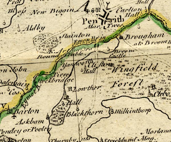 BO18NY42.jpg "Clifton" circle, tower item:- Armitt Library : 2008.14.10 Image © see bottom of page |
|
|
|
||
| evidence:- | old map:- Jefferys 1770 (Wmd) placename:- Clifton |
|
| source data:- | Map, 4 sheets, The County of Westmoreland, scale 1 inch to 1
mile, surveyed 1768, and engraved and published by Thomas
Jefferys, London, 1770.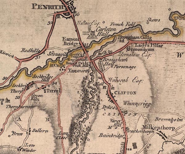 J5NY52NW.jpg "CLIFTON" blocks, labelled in block caps; village or parish? item:- National Library of Scotland : EME.s.47 Image © National Library of Scotland |
|
|
|
||
| evidence:- | old map:- West 1784 map placename:- Clifton |
|
| source data:- | Map, hand coloured engraving, A Map of the Lakes in Cumberland,
Westmorland and Lancashire, scale about 3.5 miles to 1 inch,
engraved by Paas, 53 Holborn, London, about 1784. Ws02NY52.jpg item:- Armitt Library : A1221.1 Image © see bottom of page |
|
|
|
||
| evidence:- | old text:- Clarke 1787 placename:- Clifton item:- salt |
|
| source data:- | Guide book, A Survey of the Lakes of Cumberland, Westmorland,
and Lancashire, written and published by James Clarke, Penrith,
Cumberland, and in London etc, 1787; published 1787-93. goto source goto sourcePage 6:- "..." "... I am in possession of an old boundary-roll (taken at the perambulation of Gilbert de Engayne, in the 21st year of Edward III. at which time he settled the whole village of Clifton upon his son Henry, and Johanna his wife) and this likewise begins at Bradwath. ..." "From the Bridge [Lowther Bridge] part of the village of Clifton may be seen; more particularly the church, and that old tower called the Hall, at the distance of about three quarters of a mile. This village, (which consists of about forty houses, all very neat,) formerly belonged to Hugh de Morville, and was given by him to Gilbert de Engayne before the forfeiture of his other estates. In the family of the Engaynes it continued until the marriage of Elinora, the only daughter of the family, to William Wybergh, and in the Wybergh family it hath ever since continued. During the civil wars they fell into distress through the oppressions of those times, when the manor of Clifton was mortgaged to Sir John Lowther of Lowther, and never afterwards redeemed. The present possessor is Thomas Wybergh Esq; Counsellor at law." "An ancient customary service exacted from the tenants of this manor was, "to go to St Bees with man and horse, to fetch salt and other necessaries from thence, once a year." They had a right to compound for this service, by paying half a crown to" goto sourcePage 7:- "the Bailiff when he went to warn them; and it is hardly necessary to observe, that the Bailiff knew perfectly well how to time his summons. Some, however, chose rather to go than pay; and in that case they had a shilling each man from the lord, and at their return were to have bread and cheese and ale at the lord's expence. The last who went this journey was Henry Penrith, who brought salt from St Bees at the summons of John Lowther, to whom the manor was then mortgaged. This may shew us how greatly money is decreased in value within a few years in this country, as (notwithstanding the improvements of the road,) the distance which those who went to St Bees had to travel, is forty-seven miles; and before these improvements took place, the journey must have been not only longer, but very laborious." |
|
|
|
||
| evidence:- | old print:- Clarke 1787 placename:- Clifton Villa |
|
| source data:- | circle click to enlarge click to enlargeCL18.jpg "Clifton Villa" item:- Armitt Library : A6615.12 Image © see bottom of page |
|
|
|
||
| evidence:- | old map:- Cary 1789 (edn 1805) placename:- Clifton |
|
| source data:- | Map, uncoloured engraving, Westmoreland, scale about 2.5 miles
to 1 inch, by John Cary, London, 1789; edition 1805.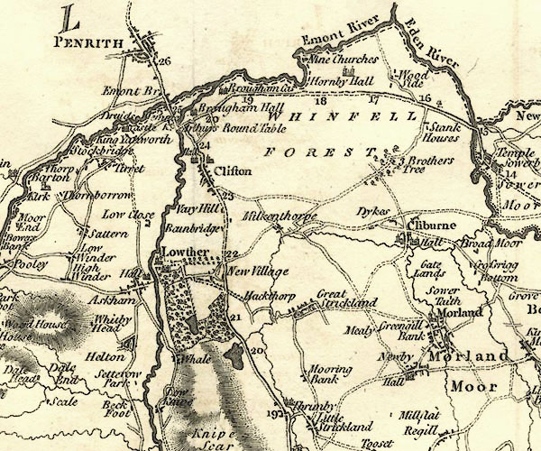 CY24NY52.jpg "Clifton" blocks, church symbol, labelled in upright lowercase; village item:- JandMN : 129 Image © see bottom of page |
|
|
|
||
| evidence:- | road book:- Cary 1798 (2nd edn 1802) placename:- Clifton |
|
| source data:- | Road book, itineraries, Cary's New Itinerary, by John Cary, 181
Strand, London, 2nd edn 1802. goto source click to enlarge click to enlargeC38267.jpg page 267-268 "Clifton - T.G." toll gate goto source click to enlarge click to enlargeC38273.jpg page 273-274 "At Clifton, on l. - Wybergh, Esq." item:- JandMN : 228.1 Image © see bottom of page |
|
|
|
||
| evidence:- | old map:- Baker 1802 placename:- Clifton |
|
| source data:- | Perspective road maps with sections in Lancashire, Westmorland
and Cumberland, by J Baker, London 1802.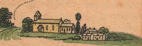 Bk03Vg08.jpg "Clifton / 284" item:- private collection : 3 Image © see bottom of page |
|
|
|
||
| evidence:- | old map:- Cooke 1802 placename:- Clifton |
|
| source data:- | Map, Westmoreland ie Westmorland, scale about 12 miles to 1
inch, by George Cooke, 1802, published by Sherwood, Jones and
Co, Paternoster Road, London, 1824. click to enlarge click to enlargeGRA1Wd.jpg "Clifton" blocks, italic lowercase text, village, hamlet, locality item:- Hampshire Museums : FA2000.62.4 Image © see bottom of page |
|
|
|
||
| evidence:- | old map:- Laurie and Whittle 1806 placename:- Clifton |
|
| source data:- | Road map, Completion of the Roads to the Lakes, scale about 10
miles to 1 inch, by Nathaniel Coltman? 1806, published by Robert
H Laurie, 53 Fleet Street, London, 1834. click to enlarge click to enlargeLw18.jpg "Clifton 285¼" village or other place; distance from London item:- private collection : 18.18 Image © see bottom of page |
|
|
|
||
| evidence:- | old map:- Cooper 1808 placename:- Clifton |
|
| source data:- | Map, hand coloured engraving, Westmoreland ie Westmorland, scale
about 9 miles to 1 inch, by H Cooper, 1808, published by R
Phillips, Bridge Street, Blackfriars, London, 1808. click to enlarge click to enlargeCOP4.jpg "Clifton" circle; village or hamlet item:- Dove Cottage : 2007.38.53 Image © see bottom of page |
|
|
|
||
| evidence:- | old map:- Wallis 1810 (Wmd) placename:- Clifton |
|
| source data:- | Road map, Westmoreland, scale about 19 miles to 1 inch, by James
Wallis, 77 Berwick Street, Soho, 1810, published by W Lewis,
Finch Lane, London, 1835? click to enlarge click to enlargeWAL5.jpg "Clifton" village, hamlet, house, ... item:- JandMN : 63 Image © see bottom of page |
|
|
|
||
| evidence:- | old map:- Otley 1818 placename:- Clifton |
|
| source data:- | Map, uncoloured engraving, The District of the Lakes,
Cumberland, Westmorland, and Lancashire, scale about 4 miles to
1 inch, by Jonathan Otley, 1818, engraved by J and G Menzies,
Edinburgh, Scotland, published by Jonathan Otley, Keswick,
Cumberland, et al, 1833.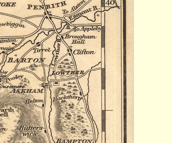 OT02NY52.jpg item:- JandMN : 48.1 Image © see bottom of page |
|
|
|
||
| evidence:- | old text:- Gents Mag |
|
| source data:- | Magazine, The Gentleman's Magazine or Monthly Intelligencer or
Historical Chronicle, published by Edward Cave under the
pseudonym Sylvanus Urban, and by other publishers, London,
monthly from 1731 to 1922. goto source Gentleman's Magazine 1816 part 2 p.601 Biographical note from the Compendium of County History:- "Seed, Jeremiah, divine, Clifton, 1605." |
|
|
|
||
| evidence:- | old map:- Hall 1820 (Wmd) placename:- Clifton |
|
| source data:- | Map, hand coloured engraving, Westmoreland ie Westmorland, scale
about 14.5 miles to 1 inch, by Sidney Hall, London, 1820,
published by Samuel Leigh, 18 Strand, London, 1820-31. click to enlarge click to enlargeHA18.jpg "Clifton" circle, italic lowercase text; settlement item:- Armitt Library : 2008.14.58 Image © see bottom of page |
|
|
|
||
| evidence:- | old map:- Ford 1839 map placename:- Clifton |
|
| source data:- | Map, uncoloured engraving, Map of the Lake District of
Cumberland, Westmoreland and Lancashire, scale about 3.5 miles
to 1 inch, published by Charles Thurnam, Carlisle, and by R
Groombridge, 5 Paternoster Row, London, 3rd edn 1843.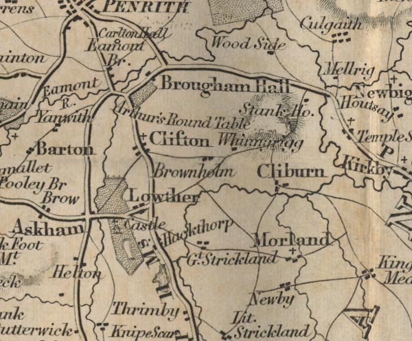 FD02NY52.jpg "Clifton" item:- JandMN : 100.1 Image © see bottom of page |
|
|
|
||
| evidence:- | old text:- Gents Mag item:- roman altar; roman inscription; inscription, roman |
|
| source data:- | Magazine, The Gentleman's Magazine or Monthly Intelligencer or
Historical Chronicle, published by Edward Cave under the
pseudonym Sylvanus Urban, and by other publishers, London,
monthly from 1731 to 1922. goto source Gentleman's Magazine 1847 part 1 pp.593-594 "ROMAN ALTAR FOUND IN CUMBERLAND."  click to enlarge click to enlargeG847E01.jpg "IN making the excavation of the Lancaster and Carlisle Railway at Clifton, the Roman Altar here represented was recently discovered. It is now the property of Mr. G. Mould, esq. of Coldale Hall, near Carlisle; who, for the inspection of the curious, has kindly deposited it in the yard of Mr. Thomas Raper, stone-cutter, in Botchergate, previous to its being placed in the private grounds adjoining his residence. The annexed engraving is copied fror the Carlisle Patriot. The two figures of a vase and praefericulum are on the sides of the altar; the back of it is plain and in a rough state." "The inscription may be read thus:-" "JOVI OPTIMO MAXIMO GENIO LOCI BRITANNICO SOLVENS VOTUM AP- OLLINA- RIS PRIN- CIPI CURAVIT FACIENDUM." "The nearest parallel inscription to this, found in Britain, with which we are acquainted, is one on an altar found at Walton Castlesteads, in the parish of Haltwhistle, on the line of the Roman Wall, (Hodgson,*p.215) -" "I O M ET G LOCI G VI ..." "In justification of our reading, "Genio loci Britannico," we may refer to another altar, found at Achindavy, also on the Roman Wall, (Hodgson, p.266) - Inscribed GENIO TERRAE BRI-" p.594 "TANNICAE M. COCCEI FIRMUS >(centurio) LEG II AUG." |
|
|
|
||
| evidence:- | old map:- Garnett 1850s-60s H placename:- Clifton |
|
| source data:- | Map of the English Lakes, in Cumberland, Westmorland and
Lancashire, scale about 3.5 miles to 1 inch, published by John
Garnett, Windermere, Westmorland, 1850s-60s.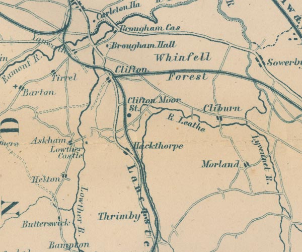 GAR2NY52.jpg "Clifton" blocks, settlement item:- JandMN : 82.1 Image © see bottom of page |
|
|
|
||
| evidence:- | old text:- Harper 1907 |
|
| source data:- | HP01p117.txt Page 117:- "..." 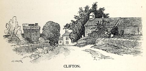 click to enlarge click to enlargeHP0111.jpg "CLIFTON." item:- JandMN : 1055.12 Image © see bottom of page |
|
|
|
||
Lakes Guides menu.