 Old Cumbria Gazetteer
 |
 |
|
| Caldbeck Fells Barytes Mines, Caldbeck | ||
| Caldbeck Fells Barytes Mines | ||
| Old Potts Gill Mine | ||
| East Potts Gill Mine | ||
| Sandbeds East Mine | ||
| Sandbeds West Mine | ||
| Deer Hills Mine | ||
| locality:- | Caldbeck Fells | |
| civil parish:- | Caldbeck (formerly Cumberland) | |
| county:- | Cumbria | |
| locality type:- | barytes mine | |
| locality type:- | mine | |
| coordinates:- | NY320361 | |
| coordinates:- | NY320365 | |
| coordinates:- | NY321361 | |
| coordinates:- | NY333362 | |
| coordinates:- | NY337359 | |
| coordinates:- | NY340358 | |
| coordinates:- | NY310365 | |
| coordinates:- | NY313365 | |
| coordinates:- | NY314363 | |
| 1Km square:- | NY3236 | |
| 1Km square:- | NY3336 | |
| 1Km square:- | NY3335 | |
| 1Km square:- | NY3435 | |
| 1Km square:- | NY3136 | |
| 10Km square:- | NY33 | |
| references:- | Adams, John: 1988: Mines of the Lake District Fells: Dalesman Books (Lancaster, Lancashire)::
ISBN 0 85206 931 6 |
|
|
|
||
| MN photo:- |
Potts Gill Mine (NY320065) - nothing much to see. |
|
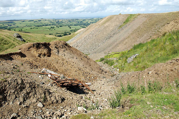 BRC66.jpg (taken 20.7.2009)  BRC65.jpg (taken 20.7.2009) |
||
|
|
||
| evidence:- | visit log:- KDMRS 1979-82 placename:- Sandbeds Mines item:- galena; malachite; copper pyrites; azurite; covellite |
|
| source data:- | Notes, log book of Geological Outings, mine plans, etc, Kendal
and District Mine Research Society, Kendal area, Cumbria, etc,
visits made 1979-82. Geological Outing of the Kendal and District Mine Research Society Log book page 85:- "DATE - 12/4/81 / MAP REF - 3300/3620 / LOCATION - CALDBECK / NAME - SANDBEDS. / TYPE OF SITE - MINES. / WORKING OR DISUSED - DISUSED. / PEOPLE IN PARTY [ ] / NOS. OF PHOTOS - NONE. / SPECIMENS FOUND - GALENA, MALACHITE, COPPER PYRITES AZURITE AND COVELLITE. / COMMENTS - DAMP MISTY SHOWERY DAY! EXTENSIVE SPOIL HEAPS OVER A WIDE AREA WITH TWO LEVELS STILL OPEN, BUT DEFINATELY (sic) NOT SAFE ENOUGH TO ENTER. SOME LEVELS OR STOPES HAVE FALLEN IN WHERE THEY COME CLOSE TO THE SURFACE. ON OUR WAY BACK WE PASSED [famous name] WHILE HE WAS OUT RUNNING, AND HIS DOG!" item:- private collection : 82 Image © see bottom of page |
|
|
|
||
| evidence:- | visit log:- KDMRS 1979-82 placename:- Potts Gill Mines item:- barytes; manganese ore |
|
| source data:- | Notes, log book of Geological Outings, mine plans, etc, Kendal
and District Mine Research Society, Kendal area, Cumbria, etc,
visits made 1979-82. Geological Outing of the Kendal and District Mine Research Society Log book page 39:- "DATE - SUNDAY 21/10/79 / MAP REF - 3200/3665 (SHEET NY33) / LOCATION - POTTS GILL / NAME - POTTS GILL MINES. / TYPE OF SITE - MINES / WORKING OR DISUSED - DISUSED / PEOPLE IN PARTY [ ] / NOS. OF PHOTOS - 24 / SPECIMENS FOUND - BARYTES AND MANGANESE / COMMENTS - WARM DAY. EXTENSIVE SPOIL HEAPS, CRATERS, AND DEPRESSIONS VISIBLE. NO LEVELS LEFT OPEN, WITH THE EXCEPTION OF A FEW HOLES LEADING INTO LEVELS ON THE TOP OF THE MOOR, THESE ARE COLLAPSES SHOWING WORKINGS UNDERNEATH AND ARE DANGEROUS AND SHOULD NOT BE ENTERED" item:- private collection : 82 Image © see bottom of page |
|
|
|
||
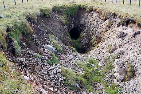 BRD04.jpg Shaft at (taken 20.7.2009) 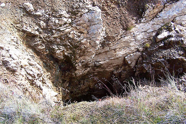 BRD05.jpg Shaft at (taken 20.7.2009) |
||
|
|
||
| :- |
Group of mines begun in the 1940s; abandoned 1966. |
|
| various veins, baryte. |
||
| Adams, John: 1988: Mines of the Lake District Fells: Dalesman Books (Lancaster, Lancashire)::
ISBN 0 85206 931 6 |
||
|
|
||
 Lakes Guides menu.