 Old Cumbria Gazetteer
 |
 |
|
|
| Burlington Quarry tramroad | |||
| site name:- | Burlington Quarry | ||
| civil parish:- | Kirkby Ireleth (formerly Lancashire) | ||
| civil parish:- | Broughton West (formerly Lancashire) | ||
| county:- | Cumbria | ||
| locality type:- | tramroad | ||
| locality type:- | narrow gauge railway | ||
| coordinates:- | SD23968366 (etc) | ||
| 1Km square:- | SD2383 | ||
| 10Km square:- | SD28 | ||
|
|
|||
| evidence:- | old map:- OS County Series (Lan 11 5) |
||
| source data:- | Maps, County Series maps of Great Britain, scales 6 and 25
inches to 1 mile, published by the Ordnance Survey, Southampton,
Hampshire, from about 1863 to 1948.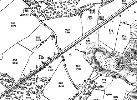 click to enlarge click to enlargeCSRY0210.jpg "TRAMWAY/ Incline" |
||
|
|
|||
| hearsay:- |
An inclined tramroad, 3 feet 2¼inch gauge, was planned from the Kirkby terminus, of
the Furness Railway, up 500 feet to the Earl of Burlington's quarry on Kirkby Moor,
Kirkby Ireleth, Cumbria, 1844. |
||
|
|
|||
| person:- | railway company : Furness Railway; FR |
||
| date:- | 1844 |
||
|
|
|||
| goes through:- | [Kirkby Station, Kirkby Ireleth] Kirkby Moor Quarry, Kirkby Ireleth Kirkby Moor Quarry, Kirkby Ireleth23.5.1844: authorized - |
||
|
|
|||
Lakes Guides menu.