 Old Cumbria Gazetteer
 |
 |
|
| boundary stone, Stainmore (2) | ||
| civil parish:- | Stainmore (formerly Westmorland) | |
| county:- | Cumbria | |
| locality type:- | boundary stone | |
| locality type:- | county boundary mark (?) | |
| coordinates:- | NY83131994 | |
| 1Km square:- | NY8319 | |
| 10Km square:- | NY81 | |
| county:- | Durham | |
| current boundary | ||
| locality:- | Cumbria boundary (?) | |
| old boundary | ||
| locality:- | Westmorland boundary (?) | |
|
|
||
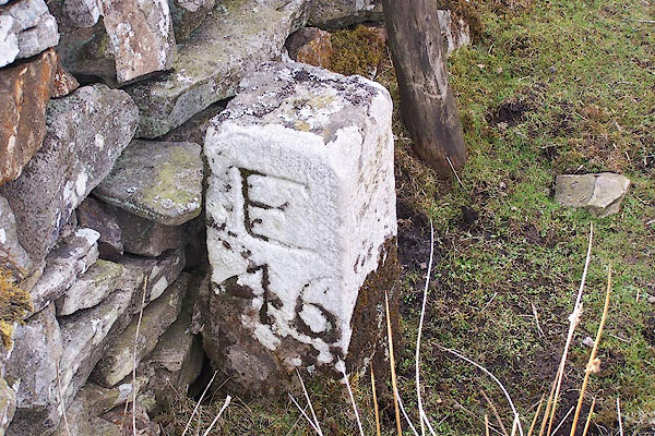 BLX44.jpg Inscribed stone:- "E 46" (taken 21.4.2006) |
||
|
|
||
| evidence:- | database:- Listed Buildings 2010 |
|
| source data:- | courtesy of English Heritage "BOUNDARY STONE SET AGAINST WALL CIRCA 10 FOOT FROM ROAD / / B6276 (NORTH OF BROUGH) / STAINMORE / EDEN / CUMBRIA / II / 73384 / NY8313219942" |
|
| source data:- | courtesy of English Heritage "Boundary stone; mid C19. Single tapered stone c2 1/2 ft high, square in plan. E45 carved on east face." |
|
|
|
||
| hearsay:- |
One of a series of numbered boundary stones, this is number 16. These are alongside
a wall built when the moorland was enclosed in the 19th century; the wall a straight
line across the fell, dividing Stainmore, Westmorland, and Lunedale, then in the North
Riding of Yorkshire. |
|
| Winchester, Angus: 2000: Discovering Parish Boundaries: Shire Publications |
||
|
|
||
 Lakes Guides menu.