 Old Cumbria Gazetteer
 |
 |
|
| Bassinghyll Gunpowder Mills, Sedgwick | ||
| Bassinghyll Gunpowder Mills | ||
| Bassingill Gunpowder Mills | ||
| Basingill Gunpowder Mills | ||
| locality:- | Basin Gill | |
| site name:- | Kent, River | |
| civil parish:- | Sedgwick (formerly Westmorland) | |
| county:- | Cumbria | |
| locality type:- | gunpowder mill | |
| coordinates:- | SD50748674 (about) | |
| 1Km square:- | SD5086 | |
| 10Km square:- | SD58 | |
|
|
||
| evidence:- | old map:- OS County Series (Wmd 42 4) placename:- Basingill Mill |
|
| source data:- | Maps, County Series maps of Great Britain, scales 6 and 25
inches to 1 mile, published by the Ordnance Survey, Southampton,
Hampshire, from about 1863 to 1948. "Basingill Mill (Powder)" |
|
|
|
||
| evidence:- | probably :- Hullmandel 1826 |
|
| source data:- | 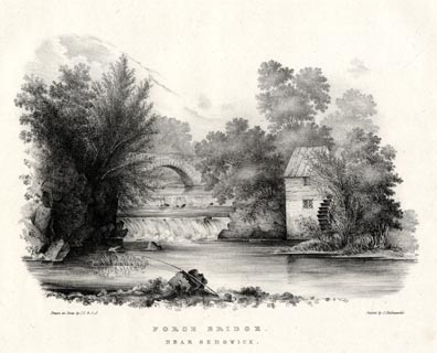 click to enlarge click to enlargeHUL102.jpg Print, uncoloured lithograph, Force Bridge, near Sedgwick, Westmorland, drawn by Miss I Cropper and Miss S Atkins, published by Charles Hullmandel, London, 1826. "Drawn on Stone by I.C & S.A. / Printed by C. Hullmandel. / FORCE BRIDGE. / NEAR SEDGWICK" item:- Armitt Library : ALMA370.2 Image © see bottom of page |
|
|
|
||
| :- |
On the River Kent, licensed 1790, to W H Wakefield and Co, operated up to 1935. |
|
| Tyler, Ian: 2002: Gunpowder Mills of Cumbria: Blue Roc Publications (Threlkeld, Keswick,
Cumbria):: ISBN 0 9523028 8 8 |
||
|
|
||
 Lakes Guides menu.