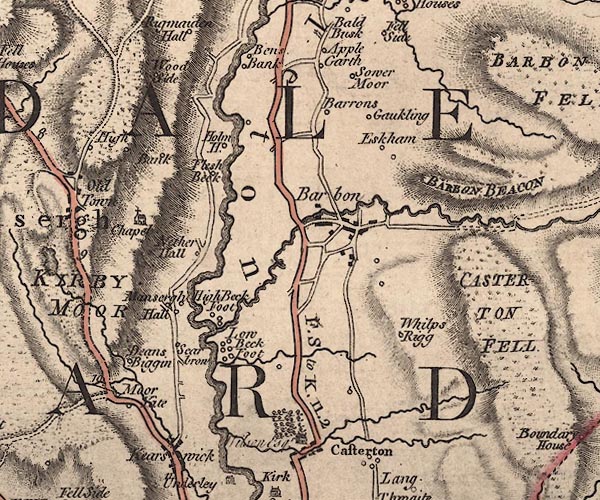
 Jefferys 1770 SD68SW

|

|
|
|
gazetteer links places may or may not be labelled on the map |
||

|
-- Applegarth -- "Apple Garth" |
|
|
|
-- Bainsbank Farm -- "Bens Bank" |
|
|
|
-- Bank -- "Bank" |
|
|
|
-- Barbon Beacon -- "BARBON BEACON" |
|
|
|
-- Barbon Beck |
|
|
|
-- Barbon -- "Barbon" |
|
|
|
-- Beckfoot Farm -- "High Beck Foot" |
|
|
|
-- Beckgate Bridge |
|
|
|
-- Borwens -- "Barrons" |
|
|
|
-- bridge, Casterton |
|
|
|
-- Casterton Beck |
|
|
|
-- Casterton Old Hall -- "Wilson Esqr." |
|
|
|
-- Deansbiggin -- "Deans Biggin" |
|
|
|
-- Eskholme -- "Eskham" |
|
|
|
-- Fleshbeck -- "Flesh Beck" |
|
|
|
-- Gawklands -- "Gaukling" |
|
|
|
-- High Beckfoot -- "High Beck Foot" |
|
|
|
-- High Moorgate -- "Moor Yate" |
|
|
|
-- Hodge Bridge |
|
|
|
-- Holme House -- "Holm H." |
|
|
|
-- Low Beckfoot -- "Low Beck Foot" |
|
|
|
-- Low Moorgate -- "Moor Yate" |
|
|
|
-- Lune, River -- "Lune River" |
|
|
|
-- Mansergh Hall -- "Mansergh Hall" |
|
|
|
-- Middleton -- "Middleton" |
|
|
|
-- Nether Hall -- "Nether Hall" |
|
|
|
-- Kirkby Lonsdale to Sedbergh -- "F. S to K. 11.2" |
|
|
|
-- Roanrigg Beck |
|
|
|
-- Scar Brow -- "Scarbrow" |
|
|
|
-- Sowermire Farm -- "Sower Moor" |
|
|
|
-- St Peter's Church -- "Chapel" |
|
|
|
-- Thorn Moor -- "BARBON BEACON" |
|
|
|
-- Whelprigg -- "Whilp Rigg" |
|
|
|
-- Woodside -- "Wood Side" |
|
|
civil parishes The area roughly includes parts of parishes:- Mansergh Middleton Barbon Casterton Kirkby Lonsdale |
||
|
|
||
|
|
Lakes Guides menu. | |