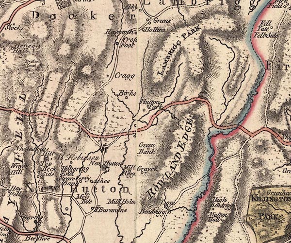
 Jefferys 1770 SD59SE

|

|
|
|
gazetteer links places may or may not be labelled on the map |
||

|
-- Ashes Farm -- "Ashes" |
|
|
|
-- Birks -- "Birks" |
|
|
|
-- Borrans Farm -- "Burnwins" |
|
|
|
-- Borrans -- "Burnwins" |
|
|
|
-- bridge, New Hutton |
|
|
|
-- Cragg Farm, The -- "Cragg" |
|
|
|
-- Crake Hall -- "Gray[ed|ca]" |
|
|
|
-- Croft Foot -- "Crof[t] Foot" |
|
|
|
-- Great Hawkrigg End -- "Haggrigg End" |
|
|
|
-- Green Bank -- "Green Bank" |
|
|
|
-- Haygarth -- "Haygarth" |
|
|
|
-- High Bendrigg -- "High Bendrigg" |
|
|
|
-- Hill Top -- "Hill Top / Mr. Robinson" |
|
|
|
-- Hollins -- "Hollins" |
|
|
|
-- Hutton Park -- "Hutton Park" |
|
|
|
-- Lambrigg Park -- "LAMBRIGG PARK" |
|
|
|
-- Latterhowe Bridge |
|
|
|
-- Little Hawrigg End -- "Haggrigg End" |
|
|
|
-- Low Bendrigg -- "Low Bendrigg" |
|
|
|
-- Millholme Mill -- "Mill Holm[ ]" |
|
|
|
-- Millrigg -- "Mill Rigg[ ]" |
|
|
|
-- Moss Head -- "Moss Yate" |
|
|
|
-- Mutton Hall -- "Mutton Hall" |
|
|
|
-- New Hutton -- "New Hutton" |
|
|
|
-- Rawhead Farm |
|
|
|
-- Kendal to Sedbergh |
|
|
|
-- Rowland Edge -- "ROWLAND EDGE" |
|
|
|
-- Strawberry Bank Farm -- "Strawberry Bank" |
|
|
civil parishes The area roughly includes parts of parishes:- Docker New Hutton Scalthwaiterigg Lambrigg Firbank Killington Old Hutton and Holmescales |
||
|
|
||
|
|
Lakes Guides menu. | |