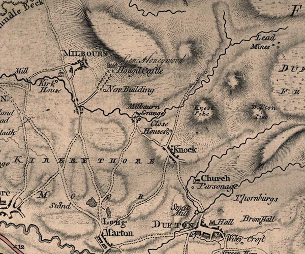
 Jefferys 1770 NY62NE

|

|
|
|
gazetteer links places may or may not be labelled on the map |
||

|
-- Close Houses -- "Close Houses" |
|
|
|
-- Dufton Hall -- "Hall" |
|
|
|
-- Eller Beck |
|
|
|
-- ford, Milburn Grange |
|
|
|
-- Gullom Holme Bridge |
|
|
|
-- Gullom Holme |
|
|
|
-- High Moor -- "KIRKBY THORE MOOR" |
|
|
|
-- Howgill Castle -- "Hougil Castle / Gen.
Honeywood" |
|
|
|
-- Kirk House -- "Kirk House" |
|
|
|
-- Knock Pike -- "Knock Pike" |
|
|
|
-- Knock -- "Knock" |
|
|
|
-- Low Howgill -- "New Building" |
|
|
|
-- Milburn Grange -- "Milbaurn Grange" |
|
|
|
-- Milburn -- "MILBOURN" |
|
|
|
-- mill, Dufton -- "Smelt Mill" |
|
|
|
-- Pus Gill |
|
|
|
-- Rectory, The -- "Parsonage" |
|
|
|
-- St Cuthbert's Church -- "Church" |
|
|
|
-- St Cuthbert's Church |
|
|
|
-- Stamp Hill -- "Stand" |
|
|
|
-- tarn, Long Marton |
|
|
|
-- Thornburgs -- "Thornburgs" |
|
|
civil parishes The area roughly includes parts of parishes:- Kirkby Thore Milburn Long Marton Dufton |
||
|
|
||
|
|
Lakes Guides menu. | |