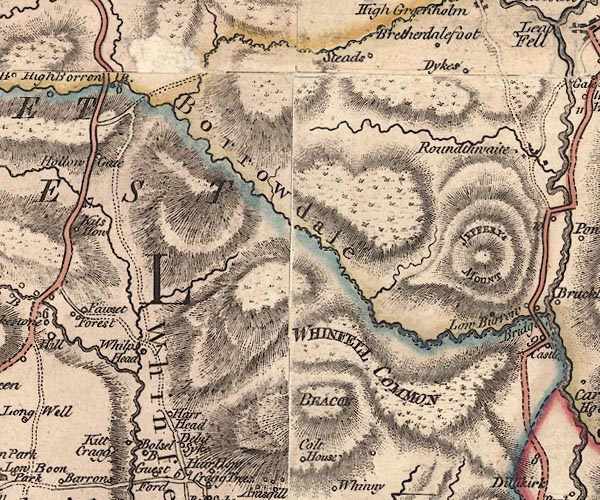
 Jefferys 1770 NY50SE

|

|
|
|
gazetteer links places may or may not be labelled on the map |
||

|
-- Ashstead Beck |
|
|
|
-- Ashstead Fell |
|
|
|
-- Bannisdale Beck -- "Banisdale B" |
|
|
|
-- Borrowdale -- "Borrowdale" |
|
|
|
-- Dyke Farm -- "Dykes" |
|
|
|
-- Evattsike -- "Debit Syke" |
|
|
|
-- Harewood -- "Harr Head" |
|
|
|
-- High Borrow Bridge -- "High Borrow B." |
|
|
|
-- Jeffrey's Mount -- "JEFFERYS MOUNT" |
|
|
|
-- Kidshowe Gill |
|
|
|
-- Kitcrag -- "Kitt Cragg" |
|
|
|
-- Lowstead -- "Steads" |
|
|
|
-- Midwath Stead -- "Steads" |
|
|
|
-- Mealbank Road (etc) |
|
|
|
-- Rossil Bridge Farm -- "Bolsel B" |
|
|
|
-- Whelpside -- "Whilps Head" |
|
|
|
-- Whinfell Beacon -- "BEACON" |
|
|
|
-- Whinfell Common -- "WHINFELL COMMON" |
|
|
|
-- Whinfell -- "Whinfell" |
|
|
civil parishes The area roughly includes parts of parishes:- Fawcett Forest Whitwell and Selside Whinfell Grayrigg Tebay Orton S |
||
|
|
||
|
|
Lakes Guides menu. | |