 Jansson 1646 NY35


|

|
|
|
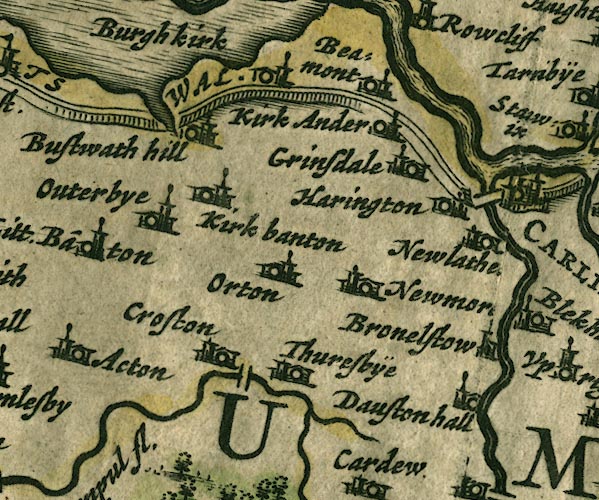
gazetteer links places may or may not be labelled on the map |
||

|
-- Beaumont -- "Beamont" |
|
|
|
-- Boustead Hill -- "Bustwath hill" |
|
|
|
-- Brownelson -- "Bronelstow" |
|
|
|
-- Burgh by Sands -- "Burgh kirk" |
|
|
|
-- Caldew Bridge |
|
|
|
-- Crofton Bridge |
|
|
|
-- Crofton -- "Croston" |
|
|
|
-- Dalston Hall -- "Dauston hall" |
|
|
|
-- Eden, River -- "Eden flude" -- "Eden flu."
-- "Eden flud" |
|
|
|
-- Great Orton -- "Orton" |
|
|
|
-- Grinsdale -- "Grinsdale" |
|
|
|
-- Hadrian's Wall -- "THE PICTS WAL." -- "THE
PICTS WAL." |
|
|
|
-- Harington (?) -- "Harington" |
|
|
|
-- Kirkandrews upon Eden -- "Kirk Ander" |
|
|
|
-- Kirkbampton -- "Kirk banton" |
|
|
|
-- Newby West -- "Newmor[e]" |
|
|
|
-- Newlaiths Hall -- "Newlathe[s]" |
|
|
|
-- Oughterby -- "Outerbye" |
|
|
|
-- Thursby -- "Thuresbÿe" |
|
|
civil parishes The area roughly includes parts of parishes:- Thursby Cummersdale Carlisle St Cuthbert Without Orton N Stanwix Rural Kirkbampton Burgh by Sands Beaumont Dalston Aikton Kingmoor |
||
|
|
||
|
|
Lakes Guides menu. | |