 Jansson 1646 NY13


|

|
|
|
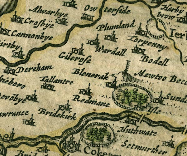
gazetteer links places may or may not be labelled on the map |
||

|
-- Allerby -- "Alwarbye" |
|
|
|
-- Moota Hill Beacon -- "Mewtoo Becon" |
|
|
|
-- Blindcrake -- "Blencrak" |
|
|
|
-- Bothel -- "Bodel" |
|
|
|
-- Bridekirk -- "Bridekirk" |
|
|
|
-- Derwent, River -- "Darwen fl." |
|
|
|
-- Gilcrux -- "Gilcross" |
|
|
|
-- Hewthwaite Hall -- "Huthwate" |
|
|
|
-- Isel Bridge |
|
|
|
-- Isel Park |
|
|
|
-- Isel -- "Isle" |
|
|
|
-- Moota Hill -- "Mewtoo Becon" |
|
|
|
-- park, Cockermouth |
|
|
|
-- Plumbland -- "Plumland" |
|
|
|
-- Redmain -- "Redmane" |
|
|
|
-- Tallentire -- "Tallantre" |
|
|
|
-- Torpenhow -- "Torpenny" |
|
|
|
-- Wardhall Guards -- "Wardall" |
|
|
civil parishes The area roughly includes parts of parishes:- Blindcrake Bridekirk Setmurthy Plumbland Cockermouth Oughterside and Allerby Bewaldeth and Snittlegarth Wythop Papcastle Embleton Brigham Blennerhasset and Torpenhow Gilcrux Bothel and Threapland |
||
|
|
||
|
|
Lakes Guides menu. | |