 Garnett 1850s-60s SD28


|

|
|
|
gazetteer links places may or may not be labelled on the map |
||

|
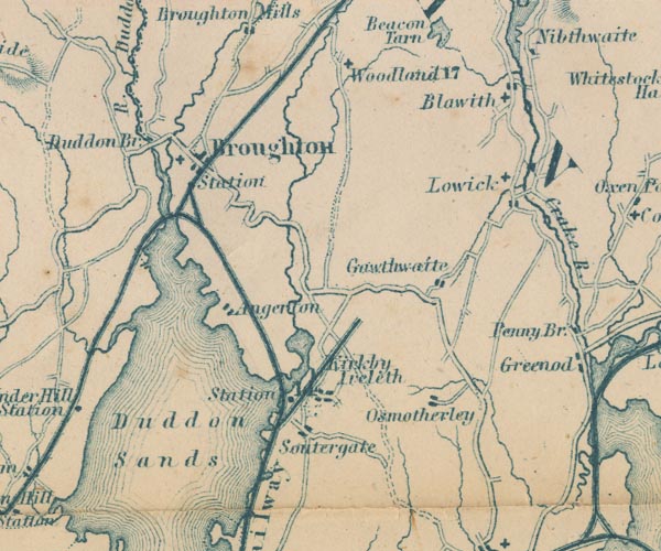
-- Angerton -- "Angerton" |
|
|
|
-- Blawith -- "Blawith" |
|
|
|
-- Broughton in Furness Station -- "Station" |
|
|
|
-- Broughton in Furness -- "Broughton" |
|
|
|
-- Blawith Church |
|
|
|
-- Coniston Railway |
|
|
|
-- Duddon Bridge -- "Duddon Br." |
|
|
|
-- Duddon Sands -- "Duddon Sands" |
|
|
|
-- Duddon, River -- "R. Duddon" |
|
|
|
-- Furness Railway -- "Furness Railway" --
"Furness Railway" |
|
|
|
-- Gawthwaite -- "Gawthwaite" |
|
|
|
-- Kirkby Pool |
|
|
|
-- Kirkby Station -- "Sta" |
|
|
|
-- Lickle, River |
|
|
|
-- Lowick -- "Lowick" |
|
|
|
-- Soutergate -- "Soutergate" |
|
|
|
-- St John's Church |
|
|
|
-- St Luke's Church |
|
|
|
-- St Mary's Church |
|
|
|
-- Whitehaven and Furness Junction Railway -- "Whitehaven &
Furness Junction Raily." |
|
|
|
-- Woodland -- "Woodland" |
|
|
civil parishes The area roughly includes parts of parishes:- Blawith and Subberthwaite Kirkby Ireleth Mansriggs Osmotherley Pennington Colton Egton with Newland Dunnerdale-with-Seathwaite Millom Without Lowick Broughton West Angerton |
||
|
|
||
|
|
Lakes Guides menu. | |