 Ford 1839 map NY55


|

|
|
|
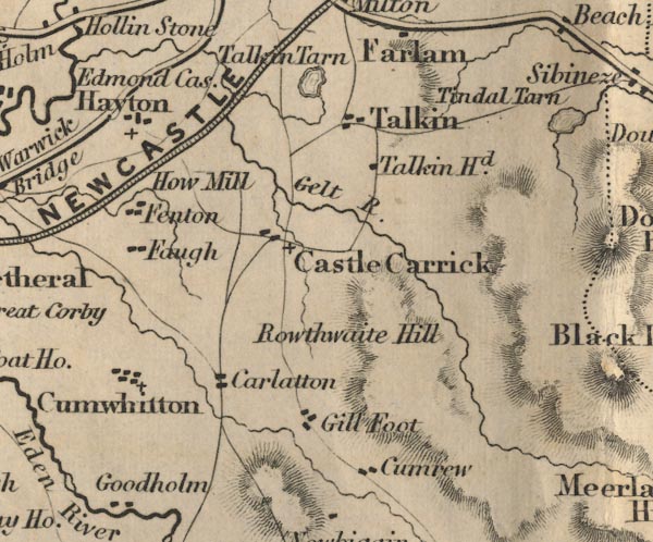
gazetteer links places may or may not be labelled on the map |
||

|
-- Carlatton Desmesne -- "Carlatton" |
|
|
|
-- Castle Carrock -- "Castle Carrick" |
|
|
|
-- Cumrew -- "Cumrew" |
|
|
|
-- Cumwhitton -- "Cumwhitton" |
|
|
|
-- Edmond Castle -- "Edmond Castle" |
|
|
|
-- Faugh -- "Faugh" |
|
|
|
-- Fenton -- "Fenton" |
|
|
|
-- Gelt, River -- "Gelt R." |
|
|
|
-- Gill Foot -- "Gill Foot" |
|
|
|
-- Hayton -- "Hayton" |
|
|
|
-- How Mill -- "How Mill" |
|
|
|
-- Newcastle and Carlisle Railway-- Newcastle and Carlisle
Railway-- Newcastle and Carlisle Railway-- Newcastle and Carlisle
Railway-- Newcastle and Carlisle Railway -- "NEWCASTLE AND
CARLISLE RAILWAY" |
|
|
|
-- Roughet Hill -- "Rowthwaite Hill" |
|
|
|
-- Talkin Tarn -- "Talkin Tarn" |
|
|
|
-- Talkin -- "Talkin" |
|
|
|
-- Talkinhead -- "Talkin Hd." |
|
|
civil parishes The area roughly includes parts of parishes:- Castle Carrock Cumrew Midgeholme Cumwhitton Geltsdale Carlatton Hayton Brampton Ainstable Farlam |
||
|
|
||
|
|
Lakes Guides menu. | |