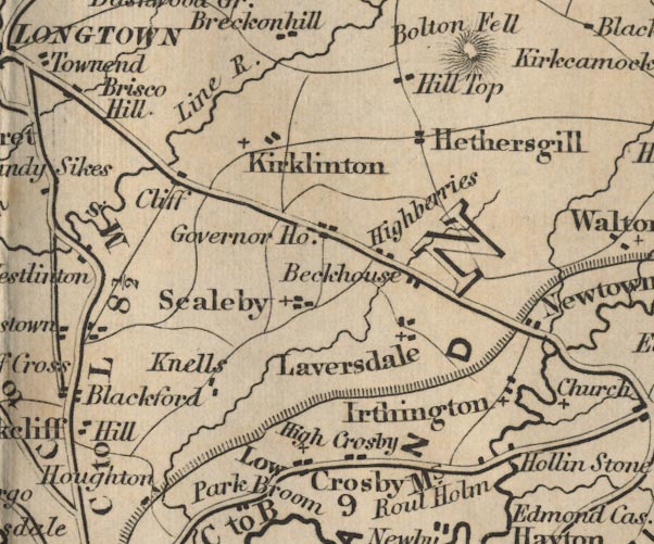
 Ford 1839 map NY46


|

|
|
|
gazetteer links places may or may not be labelled on the map |
||

|
-- Beckhouse -- "Beckhouse" |
|
|
|
-- Cliff -- "Cliff" |
|
|
|
-- Crosby on Eden -- "High Crosby" |
|
|
|
-- Hadrian's Wall |
|
|
|
-- Hethersgill -- "Hethersgill" |
|
|
|
-- Highberries -- "Highberries" |
|
|
|
-- Hollin Stone -- "Hollin Stone" |
|
|
|
-- Hunley -- "Governor House" |
|
|
|
-- Irthington -- "Irthington" |
|
|
|
-- Kirklinton -- "Kirklinton" |
|
|
|
-- Knells -- "Knells" |
|
|
|
-- Laversdale -- "Laversdale" |
|
|
|
-- Lodge Hill -- "Hill Top" |
|
|
|
-- Low Crosby -- "Low Crosby" |
|
|
|
-- Lyne, River -- "Line R." |
|
|
|
-- Newtown -- "Newtown" |
|
|
|
-- Brampton to Carlisle -- "C to B 9 Ms." |
|
|
|
-- Ruleholme -- "Roul Holm" |
|
|
|
-- Scaleby -- "Scaleby" |
|
|
civil parishes The area roughly includes parts of parishes:- Irthington Westlinton Arthuret Stanwix Rural Brampton Scaleby Walton Stapleton Kirklinton Middle Hethersgill |
||
|
|
||
|
|
Lakes Guides menu. | |