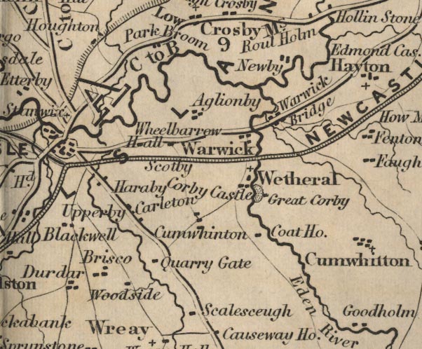
 Ford 1839 map NY45


|

|
|
|
gazetteer links places may or may not be labelled on the map |
||

|
-- Aglionby -- "Aglionby" |
|
|
|
-- Brisco -- "Brisco" |
|
|
|
-- Carleton -- "Carleton" |
|
|
|
-- Corby Castle -- "Corby Castle" |
|
|
|
-- Cote House -- "Coat Ho." |
|
|
|
-- Cumwhinton -- "Cumwhinton" |
|
|
|
-- Durdar -- "Durdar" |
|
|
|
-- Eden, River -- "Eden R." |
|
|
|
-- Great Corby -- "Great Corby" |
|
|
|
-- Harraby -- "Haraby" |
|
|
|
-- Newby East -- "Newby" |
|
|
|
-- Newcastle and Carlisle Railway-- Newcastle and Carlisle
Railway-- Newcastle and Carlisle Railway-- Newcastle and Carlisle
Railway-- Newcastle and Carlisle Railway -- "NEWCASTLE AND
CARLISLE RAILWAY" |
|
|
|
-- Parkbroom -- "Park Broom" |
|
|
|
-- Quarry Gate -- "Quarry Gate" |
|
|
|
-- Brampton to Carlisle -- "C to B 9 Ms." |
|
|
|
-- Carlisle to Alston -- "C to A 32 Ms." |
|
|
|
-- Penrith to Carlisle -- "P to C 18 Ms." |
|
|
|
-- Scalesceugh -- "Scalesceugh" |
|
|
|
-- Scotby -- "Scotby" |
|
|
|
-- Upperby -- "Upperby" |
|
|
|
-- Warwick Bridge -- "Warwick Bridge" |
|
|
|
-- Warwick -- "Warwick" |
|
|
|
-- Wetheral -- "Wetheral" |
|
|
|
-- Wheelbarrow Hall -- "Wheelbarrow Hall" |
|
|
|
-- Woodside -- "Woodside" |
|
|
civil parishes The area roughly includes parts of parishes:- Hayton Cumwhitton Brampton St Cuthbert Without Carlisle Stanwix Rural Wetheral Irthington |
||
|
|
||
|
|
Lakes Guides menu. | |