 Ford 1839 map NY44


|

|
|
|
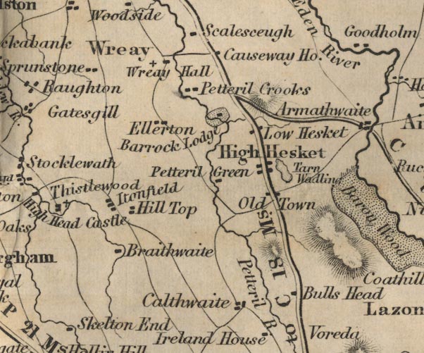
gazetteer links places may or may not be labelled on the map |
||

|
-- Barrock Park -- "Barrock Lodge" |
|
|
|
-- Braithwaite Hall -- "Braithwaite" |
|
|
|
-- Bulls Head -- "Bulls Head" |
|
|
|
-- Calthwaite -- "Calthwaite" |
|
|
|
-- Causeway House -- "Causeway Ho." |
|
|
|
-- Ellerton Grange -- "Ellerton" |
|
|
|
-- High Hesket -- "High Hesket" |
|
|
|
-- Hill Top -- "Hill Top" |
|
|
|
-- Itonfield -- "Itonfield" |
|
|
|
-- Low Hesket -- "Low Hesket" |
|
|
|
-- Old Town -- "Old Town" |
|
|
|
-- Petteril Crooks -- "Petteril Crooks" |
|
|
|
-- Petteril Green -- "Petteril Green" |
|
|
|
-- Petteril, River -- "Petteril R." |
|
|
|
-- Carlisle to Alston -- "C to A 32 Ms." |
|
|
|
-- Penrith to Carlisle -- "P to C 18 Ms." |
|
|
|
-- Sprunston -- "Sprunstone" |
|
|
|
-- Tarn Wadling -- "Tarn Wadling" |
|
|
|
-- Wreay Hall -- "Wreay Hall" |
|
|
|
-- Wreay -- "Wreay" |
|
|
civil parishes The area roughly includes parts of parishes:- Lazonby Hesket Cumwhitton Dalston Castle Sowerby St Cuthbert Without Wetheral Skelton |
||
|
|
||
|
|
Lakes Guides menu. | |