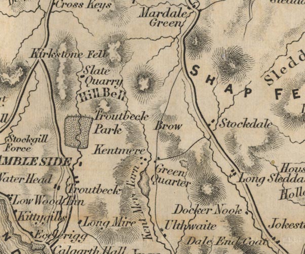
 Ford 1839 map NY40


|

|
|
|
gazetteer links places may or may not be labelled on the map |
||

|
-- Docker Nook -- "Docker Nook" |
|
|
|
-- Green Quarter -- "Green Quarter" |
|
|
|
-- Hallow Bank -- "Brow" |
|
|
|
-- Ill Bell -- "Hill Bell" |
|
|
|
-- Kentmere Tarn -- "Kent Mere Tarn" |
|
|
|
-- Longmire -- "Long Mire" |
|
|
|
-- Longsleddale -- "Long Sleddale" |
|
|
|
-- Park Quarry (?) -- "Slate Quarry" |
|
|
|
-- Red Screes -- "Kirkstone Fell" |
|
|
|
-- Shap Fells -- "SHAP FELLS" |
|
|
|
-- Stockdale -- "Stockdale" |
|
|
|
-- Gatescarth to Mardale |
|
|
|
-- Sadgill to Gatescarth |
|
|
|
-- Troutbeck Park -- "Troutbeck Park" |
|
|
|
-- Troutbeck -- "Troutbeck" |
|
|
|
-- Ullthwaite -- "Ulthwaite" |
|
|
civil parishes The area roughly includes parts of parishes:- Kentmere Shap Rural Hugill Strickland Roger Longsleddale Over Staveley Patterdale Lakes Windermere |
||
|
|
||
|
|
Lakes Guides menu. | |