 Ford 1839 map NY14


|

|
|
|
gazetteer links places may or may not be labelled on the map |
||

|
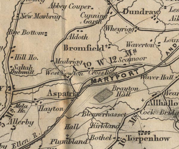
-- Aldoth -- "Aldoth" |
|
|
|
-- Arkleby Hall -- "Hall" |
|
|
|
-- Aspatria -- "Aspatria" |
|
|
|
-- Blennerhasset -- "Blennerhasset" |
|
|
|
-- Brayton Park -- "Brayton Hall" |
|
|
|
-- Bromfield -- "Bromfield" |
|
|
|
-- Cock Bridge -- "Cock Bridge" |
|
|
|
-- Crossrigg -- "Cross Rigg" |
|
|
|
-- Hayton -- "Hayton" |
|
|
|
-- Kirkland Guards -- "Kirkland" |
|
|
|
-- Maryport and Carlisle Railway -- "MARYPORT AND CARLISLE
RAILWAY" |
|
|
|
-- Mealrigg -- "Meabrigg" |
|
|
|
-- Cockermouth to Carlisle -- "C to W 16 Ms." --
"W to C 11" |
|
|
|
-- Rye Bottom -- "Rye Bottom" |
|
|
|
-- Seymour House -- "Scamoor" |
|
|
|
-- Torpenhow -- "Torpenhow" |
|
|
|
-- Westnewton -- "West Newton" |
|
|
|
-- Wheyrigg -- "Wheyrigg" |
|
|
civil parishes The area roughly includes parts of parishes:- Blennerhasset and Torpenhow Allonby Bromfield Westnewton Hayton and Mealo Boltons Holme Abbey Holme Low Dundraw Bothel and Threapland Holme St Cuthbert Oughterside and Allerby Plumbland Aspatria Allhallows |
||
|
|
||
|
|
Lakes Guides menu. | |