 Wordsworth's Guide through the District of
the Lakes, 1835
Wordsworth's Guide through the District of
the Lakes, 1835

|

|
|
|

|
title page | ||
|
preliminary pages
|
|||
|
frontispiece map |
|||
frontispiece
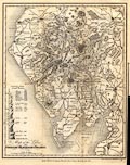 Folded and tipped in, a Map of the Lakes OF Cumberland, Westmorland & Lancashire. scale about 5.5 miles to 1 inch, by Sidney Hall, Bury Street, Bloomsbury, London, 1822. Drawn & Engraved by Sidy. Hall, Bury Strt. Bloomsby. London, Published by Longman, Hurst, Rees, Orme, & Brown, Paternoster Row, 1822. |
|||
|
|
|||
Lakes Guides menu.