 British Rainfall 1884, map

|

|
|
|

|
introduction | ||
|
|
previous | ||
|
British Rainfall 1884, map
Rainfall, Mapped by Bar Charts An example of a countrywide rainfall map
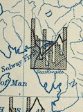 Rainfall map, Monthly Rainfall of 1884, using bar charts, England and Wales, by G J Symons, published by Edward Stanford and Co, 6 Charing Cross, and Simpkin, Marshall and Co, Stationers' Hall Court, London, 1885.
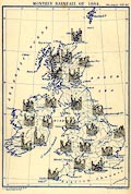 Different ways of plotting monthly rainfall are discussed in an article pp.25-28 and 2 plates. Later in the volume, p.149, Mr Symons says:- The New Map - This (see Frontispiece) is a new departure in rainfall work, and the outcome of the enquiry already mentioned. I am not going to pronounce it a perfect success. I am not sure that in steering clear of the Scylla of representing the rainfall of such places as Boston and Seathwaite on the same scale, I have not wrecked the ship in the Charybdis of uniformity. ... Each vertical column represents one month, beginning of course with January. The length of each column shows how much per cent. of the average yearly rain, fell in each month ... |
|||
|
|
next | ||
|
|
|||
Lakes Guides menu.