 Gents Mag 1760 opp p.108

|

|
|
|

|
introduction | ||
|
|
list, 3rd qtr 18th century | ||
|
Gentleman's Magazine 1760 opp p.108
|
|||
|
Irish Sea M Thurot invasion |
|||
|
Thurot in the Irish
Sea
Chart, uncoloured engraving, A Correct Chart of the Irish Sea, scale about 43 miles to 1 inch, engraved by J Gibson, published by the Gentleman's Magazine, 1760.
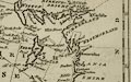 A Correct Chart of the IRISH SEA, &C. exhibiting a View of the several Islands & Bays lately touch'd at by M. THUROT, in his Attempt upon IRELAND map type: Gibson 1760 Size: wxh, sheet = 21x25.5cm; wxh, map = 181x233mm approx; scale: 1 to 2700000? The expedition of M Thurot, and a biography, is described in the Magazine, pp.107-112; and includes nothing of direct relevance to Cumbria. |
|||
|
gazetteer links
|
|||
|
|
-- (coasts, Cumbria) | ||
|
|
|||
Lakes Guides menu.