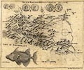


Map, uncoloured engraving, Map of the Black Lead Mines in Cumberland, and area, scale about 2 miles to 1 inch, probably by George Smith, with an article by GS, published by the Gentleman's Magazine, 1751.
The map includes Cockermouth, Keswick, Borrowdale etc, south to Seathwaite.


MAP of the BLACK LEAD MINES &c. in CUMBERLAND See p.51. Vol.XXI.
map type: Gents Mag 1751
The magazine title page, May 1751, which is p.191, explains the extra images: '... a Map of the Black Lead Mines in Cumberland, in which is tracked Mr Smith's journey, related p.51. A Representation of several ancient Coins found about Porchester Castle, near Portsmouth; and an uncommon Fish called a Bourse ...'

 Gents Mag 1751 opp p.51