 Simpson 1746 map

|

|
|
|
map type:- Simpson 1746 map |
|
|
|
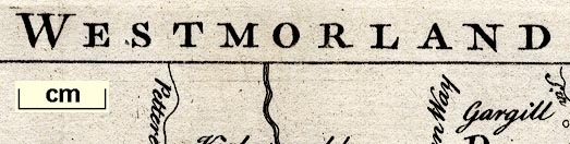
Maps, Westmorland, scale about 8 miles to 1 inch, and
Cumberland? printed by R Walker, Fleet Lane, London, 1746.
Included in The Agreeable Historian by Samuel Simpson. The title page states '... after the Designs of HERMAN MOLL, and others. ...'; the map has much the same detail as the map by Moll 1724. |
||
|
(map example Dove Cottage : 2007.38.60)
|
||
| map feature:- | coat of arms (spurious) & compass rose & up is N & scale line & sea plain & coast form lines & rivers & lakes & relief & hillocks & woods & trees & parks & county & settlements & roads | |
| inscription:- |
printed top
WESTMORLAND |
|
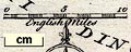
| wxh, sheet:- | 20.5x17cm | |
| wxh, map:- | mm189x154 | |
| scale line:- | 10 miles = 32.3 mm | |
| scale:- | 1 to 500000 ? (1 to 498249 from scale line wrongly assuming a statute mile) | |
|
||
| references:- |
Simpson, Samuel: 1746: Agreeable Historian & Compleat
English Traveller: Walker, R (London) |
|
| sources:- |
Chubb 1927 (CLXXXIV) Wordsworth Trust Collection Armitt Library |
|
| items seen (illustrated items in bold):- | ||

|
Armitt Library : ALMC2008.14.90 -- map -- Westmorland | |
|
|
Carlisle Library : Map 70 -- map -- Westmorland | |
|
|
Dove Cottage : 2007.38.59 -- map -- Westmorland | |