 Westmoreland

|

|
|
|
map type:- Reid and Wallis 1820 |
|
|
|
Maps, Westmoreland, scale about 14.5 miles to 1 inch, and
Cumberland? printed by James Wallis, Berwick Street, Soho,
published by W H Reid, Charing Cross, London, about 1820.
Published in 'The Panorama: or, Traveller's Instructive Guide: through England & Wales: exhibiting all the direct & principal cross roads, Cities, Towns, Villages, Parks, Canals, etc., accompanied by a Description of each County, with the Cities & Principal Towns: likewise a List of Fairs, London & County Bankers, members of Parliament, the Route of the Mail Coaches, & the Portage of Letters, with a variety of other useful information. London: Printed by J. Wallis, Berwick Street, Soho; and Published by W. H. Reid, Charing cross,' 1820. |
||
|
(example map Armitt Library : ALMC2008.14.51)
|
||
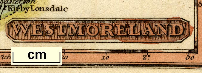
| map feature:- | title cartouche & north point & up is N & scale line & lat and long scales (rectangular projection, longitude from Greenwich) & coast line & rivers & lakes (??) & parks & county & settlements & roads & post roads | |
| inscription:- |
printed lower right
WESTMORELAND |
|
| wxh, sheet:- | 12x8cm | |
| wxh, map:- | 105x69mm | |
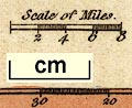
| inscription:- |
printed above scale line
Scale of Miles |
|
| scale line:- | 8 miles = 13.9 mm | |
| scale:- | 1 to 930000 ? (1 to 926241 from scale line assuming a statute mile) | |
| longitude, Kendal:- | 2d 46m W (approx) | |
|
||
| references:- |
Wallis, J & Reid, W H: 1820: Panorame of England and Wales &
Traveller's Instructive Guide: (London) |
|
| sources:- |
Chubb 1927 (CCCLXXII) Armitt Library |
|
| items seen (illustrated items in bold):- | ||

|
Armitt Library : ALMC2008.14.51 -- map -- Westmoreland | |