 Winander Mere

|

|
|
|
map type:- Prior 1874 map 1 |
|
|
|
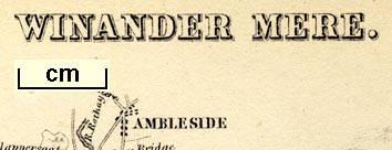
Map, Winander Mere, scale about 2.5 miles to 1 inch,
published by John Garnett, Windermere, Westmorland, 1874.
Tipped in as frontispiece to A Sail on Winander Mere, by Herman Prior, There are six vignette scenes around the map - Wray Castle; Ferry Hotel; Crown Hotel Bowness; Low Wood Hotel; Bowness; and Windermere Hotel. Notice the Kendal and Windermere Railway, called the London & N.W. Railway, and the Lakeside branch railway, called the Midland Railway. |
||
|
(example private collection (133_1))
|
||
| map feature:- | vignettes & north point & up is N & scale line & rivers & lakes & woods & trees & county (the boundary is drawn across the lake) & settlements & roads & railways | |
| inscription:- |
printed top
WINANDER MERE. |
|
| inscription:- |
printed bottom
Published by J. Garnett, Windermere. |
|
| wxh, page:- | 12x17cm | |
| inscription:- |
printed with scale line
Miles |
|
| scale line:- | 5 miles = 53.1 mm | |
| scale:- | 1 to 150000 ? (1 to 151539 from scale line) | |
|
||
| sources:- |
private collection |
|
| items seen (illustrated items in bold):- | ||

|
private collection (133_1) -- map -- Winander Mere | |