 Jansson 1646

|

|
|
|
map type:- Jansson 1646 |
|
|
|
Map, Cumbria et Westmoria, or Cumberland and Westmorland,
scale about 3.5 miles to 1 inch, by John Jansson, Amsterdam,
Netherlands, 1646; published 1646-1724.
Published in 'Joannis Janssonii Novus Atlas, sive Theatrum Orbis Terrarum: In quo Magna Britannia, seu Angliae & Scotiae nec non Hiberniae, Regna exhibenetur. Tomus Quartus. Amstelodami. Apud Joannem Janssonium. Anno MDCXLVI.' ie 1646. The atlas has an illustrated title page, text taken from Camden's Britannia; there are maps of Insularum Britannicarum, of Magnae Britanniae et Hiberniae, of Britannia ... Heptarchia, and of Anglia Regnum; the maps are coloured; the atlas size is 9 1/2 x 16 1/4 ins. the map of Cumberland and Westmorland includes coats of arms for Marcatus, Ran. Meschems, Andrew Harkley, Raphe Nevill, Duke of Bedford, Duke of Somerset, John de Foix, and Henry Clifford. It is said to have been compiled from Saxton's and Speed's maps. The map is published with little [no] change; Latin 1646, '59; French, 1646; German, 1647; Dutch, 1647. For example - in a French edition, 'Le Nouvelle Atlas ou Theatre du Monde, Auquel est represente la Grande Bretagne, Contenant les Royaumes d'Angleterre, d'Ecosse et d'Irelande. Par Jean Jansson. Tome Quatriesme. Amstelodami, Apud Iohannem Ianssonium. Anno MDCXLVI.' 1646 and 1647. For example - in a German edition, 'Novus Atlas, oder Welt-Beschreibung, in welcher aussfuhrlich abgebildet die Konigreiche Engeland, Schotland, und Irland. Das funffte Theil. Amstelodami, Apud Joannem Janssonium. Anno MDCXLVII.' ie 1647. For example - in a Dutch edition 'Nieuwen Atlas, ofte Werelt-Beschrijvinghe, ... Het Verde Deel. Amstelodami, Apud Ioannem Ianssonium. Anno MDCLII.' ie 1652. The map may have been printed with the imprint of P Schenk and G Valk in 1683. Printed by John Overton, London, atlas 'III', about 1685. Published in 'Atlas Major, ex Novissimis, Selectissimisque, A Quovis Auctore Editis, Cum Generabilus Omnium Totius Orbis Terrarum Regnorum, Rerumpublicarum Et Insularum, Tum Particularibus in hisce sitarum Regionum Tabulis Geographicis, Juxta perfectissimam Itinerariam Seriem in hoc opere positis, consistens. Ad numerum 521 Tabularum; in Tres Tomos Divisus. Tomus I. Ex collectione Caroli Allard, Amstelo-Batavi. Amstelodami, Prostat apud Carolum Allard, Cum Privilegio Ordinum Hollandiae & Westfrisiae.' about 1705. The 1705 atlas includes coloured reprints of the county maps of 1647; it contains new maps by C Allard of the whole country etc. Published in 'Atlas Anglois, Ou Description Generale De L'Angleterre, Contenant Les Cartes Geographiques De chaque Province, avec les Genealogies des plus Illustres Familles, & les Archeveches & Eveches. A Londres, Chez David Mortier, Libraire. M.DCC.XV.' ie 1715. The 1715 atlas is a new edition of an atlas of 1714-15 which used Blaeu's map; the map has a Schenk and Valk imprint, plain on the reverse, no plate number; larger towns are shown with streets rather than a symbol; scales of latitude and longitude are added in the borders, but not a lat/long grid. Published in 'Atlas Anglois, Ou Description Generale De L'Angleterre, ... A Londres, Chez Joseph Smith, Marchand Libraire a l'Enseigne d'Inigo Jones, proche Exeter-Exchange dans le Strand. MDCCXXIV.' ie 1724. The map in the 1724 atlas is unchanged from 1715. |
||
|
(example map JandMN (88))
|
||
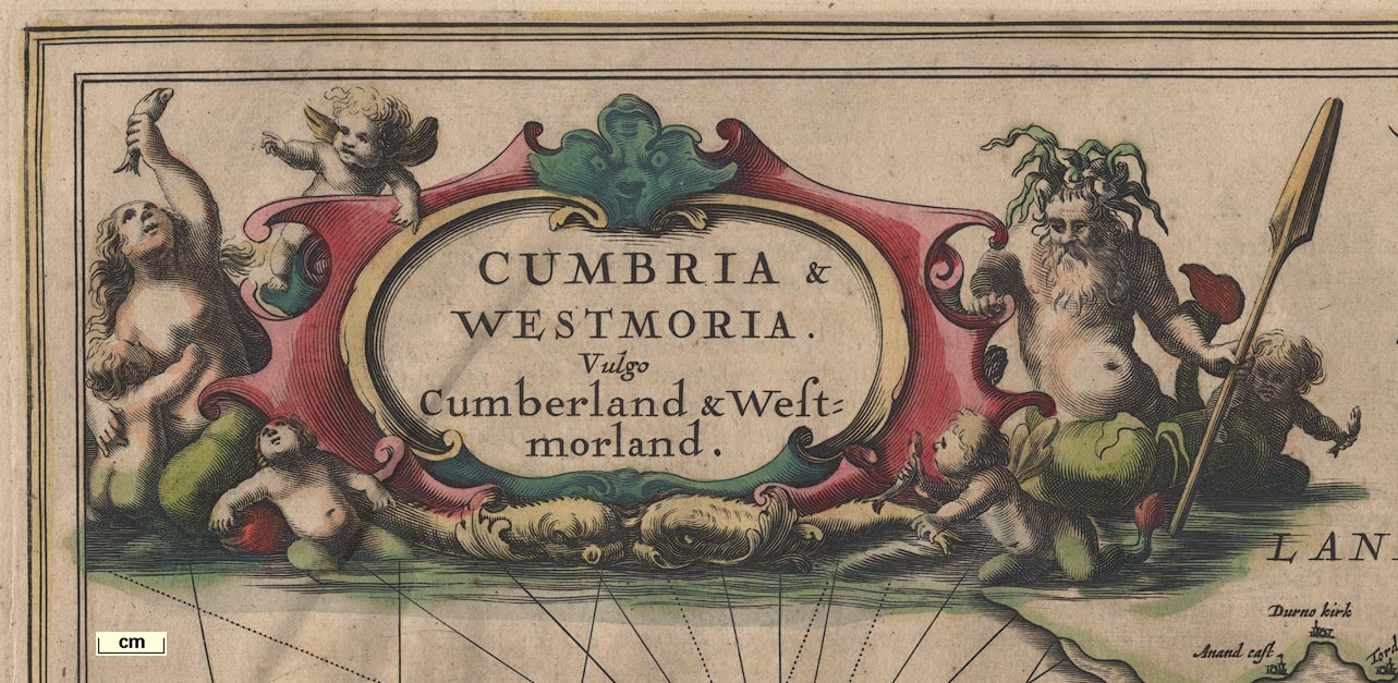
| map feature:- | scroll cartouche & coat of arms & heraldic border & compass rose & labelled borders & up is N & rhumb lines & scale line & sea plain & galleons & coast shaded & rivers & bridges & lakes & woods & forests & relief & hillocks & parks & county & settlements | |
| inscription:- |
printed title cartouche, upper left
CUMBRIA & / WESTMORIA. / Vulgo / Cumberland & West- / morland. |
|
| inscription:- |
printed lower left of centre
Amstelodami / Apud Joannem Janssonium |
|
| wxh, sheet:- | 59x50cm | |
| wxh, plate:- | 540x425mm | |
| wxh, map:- | 536x422mm | |
| scale line:- | 10 miles = 68.1 mm | |
| scale:- | 1 to 240000 ? (1 to 236321 from scale line wrongly assuming a statute mile) | |
|
||
| references:- |
Jansson, John: 1646 & 1659: Novus Atlas, sive Theatrum Orbis
Terrarum & Theatrum Orbis Terrarum: Jansson, Joannem
(Amsterdam, Netherlands): vol 4 : 1710: Atlas Major, ...: Allard, Carol (Amsterdam, Netherlands) : 1715: Atlas Anglois & Description Generale De L'Angleterre: Mortier, David (London) : 1724: Atlas Anglois: Smith, Joseph (London) Keuning, J: 1947: History of an Atlas, Mercator-Hondius: Imago Mundi: 4: pp.37-62 Keuning, J: 1951: Novus Atlas of Johannes Jannsonius: Imago Mundi: 8: pp.71-98 |
|
| sources:- |
Chubb 1927 (LXX) Curwen 1918 Skelton 1970 Hodson 1984 JandMN Collection Wordsworth Trust Collection Kendal Library Maps Carlisle Library Maps |
|
| items seen (illustrated items in bold, * have map squares etc):- | ||

|
Carlisle Library : Map 289 -- map -- Cumbria and Westmoria -- Cumberland and Westmorland | |
|
|
Dove Cottage : 2007.38.22 -- map -- Cumbria and Westmoria -- Cumberland and Westmorland | |
|
|
Dove Cottage : 2007.38.23 -- map -- Cumbria and Westmoria -- Cumberland and Westmorland | |
|
|
JandMN (88) -- map -- Cumbria and Westmoria -- Cumberland and Westmorland * | |
|
|
Kendal Library : Map 80 -- map -- Cumbria and Westmoria -- Cumberland and Westmorland | |