 Jansson 1646

|

|
|
|
item:- JandMN (88) image:- © see bottom of page |
click to enlarge |
|

|
menu with map squares and placename index | |
|
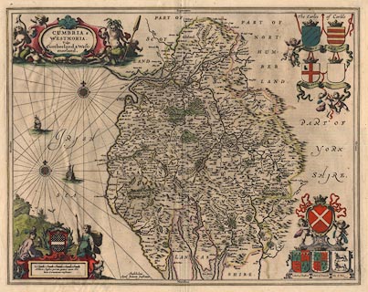
Map, hand coloured engraving, Cumbria and Westmoria, ie
Cumberland and Westmorland, scale about 3.5 miles to 1 inch,
by John Jansson, Amsterdam, Netherlands, 1646.
This example comes from a French edition of the atlas, 'Le Nouvelle Atlas ou Theatre du Monde, Auquel est represente la Grande Bretagne, Contenant les Royaumes d'Angleterre, d'Ecosse et d'Irelande' 1646 or 1647. The map has coats of arms for Marcatus, Ran. Meschems, Andrew Harkley, Raphe Nevill, John Duke of Bedford, John Duke of Somerset, John de Foix, and Lord Henry Clifford. |
||
|
|
Jansson 1646 | |
| map feature:- | scroll cartouche & coat of arms & heraldic border & compass rose & labelled borders & up is N & rhumb lines & scale line & sea plain & galleons & coast shaded & rivers & bridges & lakes & woods & forests & relief & hillocks & parks & county & settlements | |
| inscription:- |
printed title cartouche, upper left
CUMBRIA & / WESTMORIA. / Vulgo / Cumberland & West- / morland. |
|
| inscription:- |
printed lower left of centre
Amstelodami / Apud Joannem Janssonium |
|
| scale line:- | 10 miles = 68.1 mm | |
| scale:- | 1 to 240000 ? (1 to 236321 from scale line wrongly assuming a statute mile) | |
| wxh, sheet:- | 59x50cm | |
| wxh, plate:- | 540x425mm | |
| wxh, map:- | 536x422mm | |
|
|
notes | |